Management's Discussion and Analysis


Foward Looking Information

Possible Future Effects of Existing Events and Conditions

Through regionalization the USGS can respond more rapidly to changing societal needs and anticipate new trends in science research and information. With staff co-located in integrated science centers as well as dispersed across the landscape, the USGS is positioned to improve its services by fostering integrated science, enhancing partnerships, and meeting demands for increased science information at the local and regional levels. The combined expertise of co-located staff allows the USGS to provide solutions to complex environmental problems that are multidisciplinary in nature and to increase and diversify partnerships, which are key to USGS success in providing relevant science information on critical land and resource management issues. Following are a few accomplishments that illustrate success in anticipating current and future applications of integrated science and in working collaboratively with customers and partners to solve relevant societal problems.

Integrated Science Centers
Integrated science centers of the USGS - Geography, Biology, Geology, Hazards, and Water

Alaska Science Center
The USGS Alaska Science Center (ASC) was established in FY2002 for the advancement of USGS science in Alaska, the North Pacific, and the circumpolar arctic region. The ASC audience consists of scientific peers, resource and regulatory agency partners and clients, the public and elected representatives. There is one major Center in Anchorage, and two field stations in Fairbanks and Juneau, each housing various science teams linked directly to science issues and programs in Alaska and the Arctic.

The ASC has fostered improved scientific integration by: Important resource management areas in which the ASC has and will continue to play an integral role as science provider include multi-disciplinary research on northern marine, freshwater, and terrestrial ecosystems in support of sustainable energy and mineral exploration and development; impacts of global climate change on fragile and complex arctic geologic, hydrologic and biological systems; monitoring, early detection and warning for volcanic events in support of the air safety community; restoration of Gulf of Alaska marine ecosystems from the Exxon Valdez oil spill; and the development of integrated ecosystem scale models which provide decision makers with tools for understanding and predicting the consequences of alternative resource management policy and decision making scenarios.

Florida Integrated Science Center
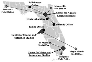
The USGS Florida Integrated Science Center (FISC) is established for the advancement of USGS science in Florida, the Southeastern States, the U.S. Caribbean, and the Nation. There are three Centers, four offices and five field stations within Florida and the U.S. Virgin Islands, housing various science teams linked directly to science issues and programs. The FISC is a field-based organization initiative to promote and enhance integrated science through scientists at the staff-level. It brings together Florida-based scientists and support staff under centralized leadership to join in working on priority issues while streamlining decision making and promoting operational efficiencies. The FISC audience consists of scientific peers, agency partners and clients, the public, and elected representatives. Organizations partnering with the USGS through the FISC include the Fish and Wildlife Service, the National Park Service, the National Oceanic and Atmospheric Administration, the Environmental Protection Agency, State and local governments, Indian Tribes, and academia.   Map showing Florida's integrated science centers. The Center for Aquatic Resource Studies oversees the activities of offices in Tallahassee, and Orlando and field stations in Jacksonville and Pensacola. The Center for Coastal and Watershed Studies oversees the Virgin Islands field office. The Center for Water and Restoration Studies oversees field offices in Ft. Myers and the Everglades. A laboratory in Ocala and an office in Tampa complete the Florida Integrated Science Center.
The FISC allows for: Some examples of areas in which the FISC has and will continue to play an integral role are: science for south Florida restoration which provided early indications of the power of multidisciplinary science, Tampa Bay Estuary Studies which demonstrated approaches in integrating science around a single system, and diverse studies in the Suwannee River Basin and coral reefs and development of these studies into fully integrated initiatives.

Integrated Science Projects

Puget Sound Integrated Science and Ecological and Hazards Research
Puget Sound is the second largest estuary in the United States. This natural and economic jewel of the Pacific Northwest supports hundreds of species of fish, including several native salmon species, and several species of marine mammals, including Orca whales. Puget Sound has a vibrant economy supported by a deep water port and major airport facilities that bring in billions of dollars of world trade, nationally important military installations, and significant economic sectors in forestry, fisheries and tourism. However, development has over-stressed both the resources and the environment throughout the Basin. Major issues impacting Puget Sound include degraded coastal habitat, water quality, and urban sprawl. Additionally, several marine species routinely being introduced into Puget Sound through ballast water discharges in coastal waters and ports have contributed to the decline of fisheries and threatened aquatic populations that have been tied to the loss of critical ecosystem functions.

USGS is engaged in an active and broad-based partnership with State, Federal and local resource agencies, tribes, commercial sector, and non-governmental organizations, to form the Puget Sound Nearshore Ecosystem Restoration (PSNER) partnership. PSNER is committed to economically sustainable protection and restoration of coastal and nearshore ecosystems in Puget Sound. Key areas of ongoing USGS research this year where progress has been made include aquatic invasive species, estuarine life history of Pacific salmon, disease effects on forage fish populations, water quality, landscape processes, earthquake and landslide hazards, and geographic and geospatial information delivery. Recognition of the complex interaction among the biological, physical and human-influenced processes dictates the need for an integrated science approach to addressing future ecosystem restoration projects in the Sound.

Federal, State, and Community Leaders Collaborate in Addressing Mancos Shale Land Use and Water-Quality Issues
Photograph of Western landscape   
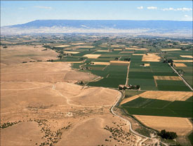
Responsible stewardship of western lands is a primary goal of many Federal and State agencies as well as non-government organizations and citizen groups. In parts of the West, much of that land is underlain by marine black shale, such as the Cretaceous age Mancos Shale of western Colorado, northern New Mexico, and eastern Utah. During the last few decades, land use and water-quality issues related to Mancos landscapes have risen in prominence in the western slope area of Colorado and parts of eastern Utah. Many immediate issues are related to specific, naturally occurring toxins such as selenium and salinity. As a result of the 2002 workshop co-sponsored by Bureau of Land Management, Bureau of Reclamation, and the USGS, a multi-disciplinary project was started in fiscal year 2003. The broad objectives of this project are to use science to help define issues of the black shale terrains, provide scientifically valid information for use in developing resource and land-use management policies, and assure the information provided is transportable and applicable to resource managers in other black-shale landscapes. One immediate outcome is improved lines of communication among the Federal, State, local, and industry managers. Long-term, the project will contribute to the development of predictive models that can be used to evaluate black shale landscapes in terms of their economic resources and their environmental sensitivity. More information can be found on the Web at http://minerals.cr.usgs.gov/projects/mancos_shale/.


USGS and the Greater Everglades
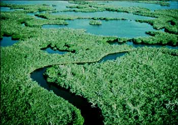
The Greater Everglades ecosystem is a unique subtropical network of diverse habitats that encompasses a large part of the southern Florida peninsula. Part of the area -- mostly publicly controlled parks, preserves, sanctuaries, and refuges managed as DOI trust resources -- remains in nearly undeveloped condition, while much of the area has been dramatically changed due to increases in urbanization and agriculture. Major changes to the natural hydrology of the system, which supports diverse ecosystems, have had profound effects on the natural habitat.

Recognition that the natural ecosystem of South Florida has been seriously altered and that continued impacts will further degrade this ecosystem has led a coalition of partners to identify and implement studies to address key restoration needs outlined in the Comprehensive Everglades Restoration Plan (CERP) related to water quantity, quality, and timing of delivery of water to the Greater Everglades ecosystem. Restoration partners include the USGS, Fish and Wildlife Service, the National Park Service, the National Oceanic and Atmospheric Administration, the Environmental Protection Agency, State and local governments, Indian Tribes and academia.
  Photograph of the Everglades
The foundation of USGS ecosystem science is integrated and multidisciplinary studies are combined with discipline-based, fundamental process research. In the Everglades, the USGS focuses its expertise to address complex biological, chemical, geologic, hydrologic, and geographic components of an ecosystem -- in this case the Greater Everglades ecosystem. Ongoing and future Greater Everglades research and studies include: USGS Research Aids in Restoring Wetlands for Carbon Storage

Carbon enters the soil as roots, litter, harvest residues, and animal manure. It is stored primarily as soil organic matter (SOM). The density (weight/volume) of carbon is highest near the soil surface. But much of the most recently deposited SOM decomposes rapidly, releasing CO2 to the atmosphere. Some carbon becomes stabilized, especially in the lower part of the soil profile. Balanced rates of input and decomposition determine steady state carbon fluxes. However, in many parts of the world, agriculture and other land-use activities have upset the natural balance in the soil carbon cycle, contributing to an alarming increase in carbon release from soils to the atmosphere in the form of CO2. Carbon sequestration in soils is a climate-change-mitigating strategy based on the assumption that movement, or flux, of carbon from the air to the soil can be increased while the release of carbon from the soil back to the atmosphere is decreased. In other words, certain activities can transform soil from a carbon source (emits carbon) into a carbon sink (absorbs carbon). This transformation has the potential to reduce atmospheric CO2, thereby slowing global warming and mitigating climate change.   
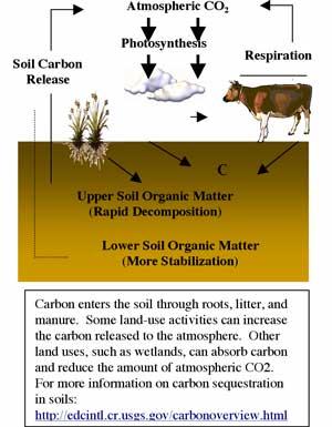
Both the DOI and USDA have expressed the need to understand the carbon cycle and in particular carbon storage to reduce the impact of greenhouse gases, such as carbon dioxide, methane, and nitrous oxide, on global warming. Other concerned parties include Congressional representatives, State agricultural officials, conservation groups, private industry, and farm groups. USGS studies indicate that greater amounts of atmospheric carbon can be stored in restored wetlands and bottomland hardwoods than in agricultural lands managed to increase storage, even though the restored area is much smaller. Wetlands in the prairie pothole region of Iowa, Minnesota, South Dakota, North Dakota, and Montana traditionally functioned as sinks for atmospheric carbon, but row crop agriculture (the current principal land use) releases carbon to the atmosphere instead of storing it. Based on USGS research, USDA added restored prairie wetlands to the National Carbon Sinks Table. To aid managers, a USGS project was started in FY2003 to (1) develop a State-by-State inventory of existing and potential wetland carbon stocks in the prairie pothole region of the United States, (2) evaluate differences in carbon storage among various wetland types, and (3) examine the interrelationship of carbon production and climate change. Similar research is underway in the Lower Mississippi Valley (LMV) and other locations to quantify potential carbon storage in soil and trees through reforestation of LMV croplands. More information can be found on the Web at http://www.npwrc.usgs.gov/resource/othrdata/amnorpln/conclu.htm.
URL for carbon Web site


U.S. Department of the Interior, U.S. Geological Survey
URL: http://pubsdata.usgs.gov/pubs/03financial/html/forward.html
Maintained by Eastern Publications Group
Last modified: 16:28:32 Tue 22 Nov 2016
Privacy statement | General disclaimer | Accessibility