Management's Discussion and Analysis


Overview of the Organization

Created by an act of Congress in 1879, the USGS has evolved over the ensuing 124 years, matching its talent and knowledge to the progress of science and technology. Today, the USGS stands as the sole science agency for the DOI. It is sought out by thousands of partners and customers for its natural science expertise and its vast earth and biological data holdings. The USGS is the science provider of choice in accessing the information and understanding to help resolve complex natural resource problems across the Nation and around the world.  
Vision

The USGS is a world leader in the natural sciences through our scientific excellence and responsiveness to society's needs.


Strategic Direction

The USGS will combine and enhance our diverse programs, capabilities, and talents and increase customer involvement to strengthen our science leadership and contribution to the resolution of complex issues.
  The USGS serves the Nation as an independent fact-finding agency that collects, monitors and analyzes natural data, and provides scientific understanding about natural resource conditions, issues, and problems. The value of the USGS to the Nation rests on its ability to carry out studies on a national scale and to sustain long-term monitoring and assessment of natural resources. Because it has no regulatory or management mandate, the USGS provides impartial science that serves the needs of our changing world. The diversity of scientific expertise enables the USGS to carry out large-scale, multi-disciplinary investigations that build the base of knowledge about the Earth. In turn, decision makers at all levels of government and citizens in all walks of life have the information tools they need to address pressing societal issues.

The thousands of scientists, technicians and support staff of the USGS are located in nearly 400 offices in every State and in several foreign countries. With an annual budget of more than $1 billion, the USGS leverages its resources and expertise in partnership with more than 2,000 agencies of State, local and tribal governments, the academic community, other Federal agencies, non-governmental organizations, and the private sector. Field investigations, direct observations of natural science processes and phenomena, and monitoring and data collection are the scientific hallmarks of the USGS.

The USGS is proud of its outstanding history of public service and scientific advances. The USGS has been at the forefront of advances in understanding the Earth, its processes, and its resources. USGS scientists pioneered hydrologic techniques for gaging the discharge in rivers and streams and modeling the flow of complex ground-water systems. Innovative ventures with the private sector have given the world access to digital images of neighborhoods and communities in one of the largest data sets ever made available online. Modern-day understanding of the formation and location of energy and mineral resource deposits is rooted in fundamental scientific breakthroughs by USGS scientists. USGS biologists revolutionized thinking about managing wildlife resources, which has provided a sound scientific basis that lets waterfowl conservation and recreational hunting work in tandem as adaptive management, not as conflicting interests. Advances in seismology are making early warnings of earthquakes a reality that will give the needed alert time to save lives. The future of the global community presents unprecedented opportunities for the science of the USGS to continue to make substantive and life-enhancing contributions to the betterment of the Nation and the world.

The Organization

Diagram showing USGS Eastern Region office in Reston, Va., the Central Region office in Lakewood, Colo., and the Western Region office in Menlo Park, Calif., along with major field offices across the country. Please visit http://www.usgs.gov/major_sites.html for more information.

The vast landscape of the Nation results in complex, interrelated, natural resource use and conservation issues that are best addressed through holistic science solutions. USGS consists of a headquarters organization located in Reston, Virginia and field offices located throughout the United States. Major Field Centers (Regional Offices) are located at Denver, Colorado, Menlo Park, California, and Reston, Virginia.

Organizational chart. See also Directory of Key Officials for a text  version of the information at http://www.usgs.gov/div_contacts/
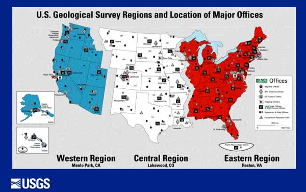
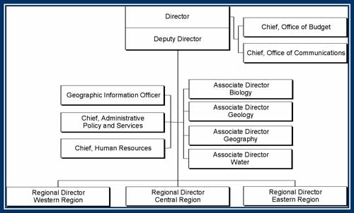
The USGS incorporates a matrix-management process that provides national senior leadership under the authority of Associate Directors responsible for overall management of the Bureau's four primary programs. Direct line authority and responsibility are vested in three Regional Directors who serve as the personal representative of the Director in their respective locations. USGS Regional Directors are responsible for ensuring that science priorities are balanced and reflect local, regional, and national needs. This management structure serves the Bureau well by locating Bureau leadership and programs closer to customers and their issues, and facilitates a citizen-centered approach where it is needed. It also encourages and strengthens lines of communication across the breadth of USGS programs and with other DOI Bureaus and other stakeholders at the regional level.


Strategic Goals and Performance Reporting

Strategic Goal --
Provide Science for a Changing
World

Two program activities:

Hazards

Focus efforts in response to
present and anticipated needs
to predict and monitor
hazardous events in near-real
and real time and to conduct
risk assessments to mitigate
loss.


Environmental and
Natural Resources

Focus efforts in response to
present and anticipated needs
to expand our understanding
of the environment and natural
resources issues on regional,
national and global scales and
enhance predictive/forecast
modeling capabilities.


Hazards

Long-Term Goal

Ensure the continued transfer of hazards-related data, risk assessments, and disaster scenarios needed by our customers before, during, and after natural disasters, and by FY2005, increase the delivery of real-time hazards information by increasing the average number of streamgages reporting real-time data on the Internet during each quarter to 5,500 (thus reducing the time it takes to provide flood information at that site from 6 to 8 weeks to 4 hours) and installing 500 improved earthquake sensors (thus reducing delivery time of information on potentially damaging earthquakes from 40 to 20 minutes) to minimize the loss of life and property.

Annual Goal

The FY2003 Annual Performance Goal is to develop, maintain and improve monitoring networks and techniques of risk assessment by: maintaining the baseline of data (average annual completion); increasing by 74 improved earthquake sensors to deliver real-time information on potentially damaging earthquakes to minimize loss of life and property and maintaining the average number of streamgages at 5,462 delivering real-time data on the Internet.

FY03 Annual Goal
GPRA Program Activity: Hazards
Performance
Develop, maintain and improve the
monitoring networks and
techniques of risk assessment
1999
Actual
2000
Actual
2001
Actual
2002
Actual
2003
Planned
2003
Actual
6 6 6 6 6 5

Results Report & Discussion: Goal Not Met
Closure and discontinuation of the Center for Integration of Natural Disaster Information (CINDI) eliminated this network. In FY2002, an interdisciplinary panel of USGS senior scientists was tasked to conduct a program and management review of the CINDI business model. The panel’s report was the basis for an executive decision to close the CINDI facility and a transition plan for FY2003 was prepared and followed. Technology has outpaced the original business model; state-of-the-art communication technology has overtaken the need for a centrally located laboratory. In addition, other USGS programs now either provide their own hazard and disaster information effectively from distant locations or provide disaster information to the public using a commercial distributor.


The DOI has developed a new strategic plan for FY2003 – FY2008 that does not contain this measure in its present form. The USGS will continue to monitor at the Bureau level.

Maintain the baseline of data and
risk assessments transferred to
customers
1999
Actual
2000
Actual
2001
Actual
2002
Actual
2003
Planned
2003
Actual
16 17 26 24 15 16
Results Report & Discussion: Goal Exceeded.
The DOI has developed a new strategic plan for FY2003 – FY2008 that does not contain this measure in its present form. The USGS will continue to monitor this at the Bureau level.
Increase by 50 improved earthquake sensors to deliver real-time information on potentially damaging earthquakes to minimize loss of life and property (Cum.)
1999
Actual
2000
Actual
2001
Actual
2002
Actual
2003
Planned
2003
Actual
120 201 329 425 499 476

Results Report & Discussion: Goal Not Met.
Plans were to install the 24 sensors that were not installed by the end of FY2002 which were installed in the 1st quarter of FY2003. Of the remaining 50 additional sensors that were to be installed in the 4th quarter, only 27 were actually installed. This was due to the fact that the appropriation came late in the fiscal year causing a problem with purchasing the equipment along with a portion of the Advanced National Seismic System (ANSS) funding was used for operation and maintenance of stations already installed and for making improvements to communication links, existing hardware, and other network elements to improve data delivery as recommended by partners and stakeholders.


The DOI has developed a new strategic plan for FY2003 – FY2008 that does not contain this measure in its present form. The USGS will continue to monitor this at the Bureau level.

Hold 28 Stakeholder Meetings
1999
Actual
2000
Actual
2001
Actual
2002
Actual
2003
Planned
2003
Actual
16 40 27 37 28 43

Results Report & Discussion: Goal Exceeded.
Additional Earthquake Studies Advisory Committee meetings were held that had not been planned. More than planned hazard-related streamgaging network meetings were also held.


The DOI has developed a new strategic plan for FY2003 – FY2008 that does not contain this measure in its present form. The USGS will continue to monitor this at the Bureau level.

Maintain the quarterly average number of streamgages (5,462) delivering real-time data on the Internet 1999
Actual
2000
Actual
2001
Actual
2002
Actual
2003
Planned
2003
Actual
4,500 4,872 5,280 5,626 5,462 5,621

Results Report & Discussion: Goal Exceeded.
The streamgage performance measure relies on two separate but related components: (1) installation of new real-time streamgages and upgrading of existing streamgages to give them real-time capability; and (2) improvements to the national computer infrastructure. Additional increase in performance above the target may be due to improvements in computer hardware infrastructure and in the software that allows users to view real-time streamgage data on the Internet.


The DOI has developed a new strategic plan for FY2003 – FY2008 that does not contain this measure in its present form. The USGS will continue to monitor this at the Bureau level.

Measure Hazards Customer Satisfaction Goal
1999
Actual
2000
Actual
2001
Actual
2002
Actual
2003
Planned
2003
Actual
Pilot Baseline Baseline
Single
Goal not Met
97% Measure
Goal
98%

Results Report & Discussion: Goal Met.
Target was to Measure Goal, which has been a consistent 98% each quarter.


The DOI has developed a new strategic plan for FY2003 – FY2008 that does not contain this measure in its present form. The USGS will monitor new customer satisfaction measures.


Geology


Earthquake Probabilities for the San Francisco Bay Region 2003-2032
At the April 2003, Disaster Resis-tant California conference in San Jose, Calif., USGS scientists and partners released a new report stating that there is a 62 percent chance that a major earthquake of magnitude 6.7 or higher, and an 80 percent chance that one or more earthquakes with a magnitude of 6.0 to 6.6 will strike the region in the next 30 years. While the urban core of the San Francisco Bay region remains at high risk, scientists identified the likelihood of additional significant earth-quakes in three of the most rapidly growing parts of the region. The report included earthquake loss estimates for the Bay area over the next 30 years. Public officials, land use planners, engineers and architects will use the new hazard assessment to develop safer building practices in this vulnerable, earthquake-prone region.

USGS Issues Volcano Hazard Assessments for Kanaga and Great Sitkin Volcanoes, Alaska
The assessments summarize USGS knowledge of the eruptive history and potential volcanic hazards from these two volcanoes in the western Aleutians. Both have erupted in historic times: Kanaga in 1993-1994 and Great Sitkin in 1974. Explosive eruptions producing ash clouds pose potential hazard to passing aircraft and to the communities of Adak and Atka, on adjacent islands, as well as to shipping and fishing activities in the vicinity. Federal and state agencies, in addition to private-sector entities with activities in the western Aleutians, will use the information in these assessments in future research.
  Photograph of Sitkin Volcano, Alaska


New Seismic Equipment Unveiled in Memphis
In October 2002, the USGS unveiled new seismic stations in the Memphis, Tennessee area that are part of the Advanced National Seismic System (ANSS), the first line of defense in the war on earthquake hazards. Federal, State and local partners and emergency re-sponders attended this event, held at the University of Memphis. The USGS is improving its earthquake monitoring and reporting capabilities through the ANSS, a nation wide network of modern strong motion seismometers that can provide emergency-response personnel with real-time "shaking" information within 3-5 minutes of an earthquake. The new seismic data will be used to improve earthquake characterizations in the mid-continent region by the USGS and regional partners, and by researchers studying seismic wave propagation, attenuation, and earthquake hazards.

Water


USGS Expands Website for Yellowstone Volcano Observatory
An updated and expanded website for the Yellowstone Volcano Observatory (YVO) was released in March 2003, replacing the initial website that was posted following the establishment of YVO in May 2001. The updated website covers activities of the three agencies involved in the operation of YVO (the USGS, Yellowstone National Park, and the University of Utah) and increases the stream of data from monitoring networks available in near real-time to the public and to other scientists working on Yellowstone issues. This website supports the program's goal of outreach and communication. Federal and State agencies, scientists, and the general public will use the information available on the website.

Fire Chiefs Want USGS Flood Inundation Maps
A new USGS flood-mapping method was described in a recent issue of the International Association of Fire Chiefs' weekly newsletter. The new USGS system can produce flood-inundation maps as much as three to five days ahead of a storm giving response personnel more time to plan and execute mitigation efforts. USGS has been contacted by fire chiefs across the country who want the new flood-mapping method for their areas. The USGS method combines high-accuracy elevation data, a new computer flow model, and a geographic information system to produce maps in real-time. Information is available at http://water.usgs.gov/pubs/wri/wri024251/.

The Charlotte Observer reported that a recent storm was a good test of the flood-monitoring system linked to USGS streamgages. The flood-monitoring system alerts emergency personnel when streamflow at USGS streamgage sites reach a certain height.
 
Map showing network of wells that monitor the effects of droughts and other climate variability on ground-water levels. Please visit http://water.usgs.gov/pubs/circ/circ1217/html/title.html for more information

The USGS maintains a network of wells to monitor the effects of droughts and other climate variability on ground-water levels. The network consists of a national network of about 150 wells monitored as part of the Ground Water Resources Program, supplemented by wells in some States monitored as part of the Cooperative Water Program.


Environmental and Natural Resources

Long-Term Goal

Ensure the continued availability of long-term environmental and natural resource information and systematic analysis and investigations needed by customers, and by FY2005, develop 20 new decision support systems and predictive tools for informed decision-making about natural systems.

Annual Goal

The FY2003 Annual Performance Goal is to provide and improve long-term environmental and natural resource information, systematic analyses and investigations, and predictive options for decision-making about natural systems by: providing essential information to address environmental and natural resources issues by maintaining 45 long-term data collection/data management efforts and supporting two large data infrastructures managed in partnership with others; delivering 971 new systematic analyses and investigations to our customers; improving and developing 8 new decision support systems and predictive tools for decision-making; and collaborating with university partners to understand natural systems and facilitate sound management practices through 209 external grants and contracts.

FY03 Annual Goal
GPRA Program Activity:
Environmental and Natural Resources
Performance
Provide and improve long-term
environmental and natural resource
information, systematic analyses
and investigations, and predictive
options for decision-making about
natural systems by providing
essential information to address
environmental and natural
resources issues by maintaining 45
long-term data collection/data
management efforts and
supporting two large data
infrastructures managed in
partnership with others
1999
Actual
2000
Actual
2001
Actual
2002
Actual
2003
Planned
2003
Actual
40
46
46
47
47
46

Results Report & Discussion: Goal Not Met
The malfunction of the Landsat 7 satellite at the end of May 2003 caused the non-collection of the bulk of information that was contributing to the long-term data collection “National Satellite Land Remote Sensing Data Archive”.

The DOI has developed a new strategic plan for FY2003 – FY2008 that does not contain this measure in its present form. The USGS will continue to monitor at a Bureau level.


Deliver 971 new systematic analyses and investigations to our customers
1999
Actual
2000
Actual
2001
Actual
2002
Actual
2003
Planned
2003
Actual
959
1,113
1,018
993
971
1,081
Results Report & Discussion: Goal Exceeded.
The DOI has developed a new strategic plan for FY2003 – FY2008 that does not contain this measure in its present form. The USGS will continue to monitor at a Bureau level.
Improve and develop 8 new decision support systems and predictive tools for decision-making
1999
Actual
2000
Actual
2001
Actual
2002
Actual
2003
Planned
2003
Actual
7
7
7
9
8
11
Results Report & Discussion: Goal Exceeded.
Three decision support systems were improved and/or updated that were not originally planned for fiscal year 2003.

The DOI has developed a new strategic plan for FY2003 – FY2008 that does not contain this measure in its present form. The USGS will continue to monitor at a bureau level.
Collaborate with university partners to understand natural systems and facilitate sound management practices through 209 external grants and contracts
1999
Actual
2000
Actual
2001
Actual
2002
Actual
2003
Planned
2003
Actual
238
209
239
182
209
160
Results Report & Discussion: Goal Not Met.
The Cooperative Research Units vary in methodologies for issuing research work orders (RWOs). The plan is still to get to the target number by the end of the calendar year. More units than usual combine RWOs to gain efficiencies in processing rather than keeping them as separate projects.

The DOI has developed a new strategic plan for FY2003 – FY2008 that does not contain this measure in its present form. This measure will be discontinued in FY2004.
Hold 544 Stakeholder meetings to learn our customer needs
1999
Actual
2000
Actual
2001
Actual
2002
Actual
2003
Planned
2003
Actual
473
468
592
767
544
806
Results Report & Discussion: Goal Exceeded.
In keeping with program evaluation recommendations by the National Research Council, USGS has doubled efforts to formally listen and respond to stakeholders and customers.

The DOI has developed a new strategic plan for FY2003 – FY2008 that does not contain this measure in its present form. This measure will be discontinued in FY2004.
90% Customers satisfied
1999
Actual
2000
Actual
2001
Actual
2002
Actual
2003
Planned
2003
Actual
Pilot
Baseline
95%
95%
90%
94%
Results Report & Discussion: Goal Met.
The DOI has developed a new strategic plan for FY2003 – FY2008 that does not contain this measure in its present form. The USGS will monitor new customer satisfaction measures.


Biology


Threatened and Endangered Species Habitat
The Central Southwest/Gulf Coast Node of the National Biological Information Infrastructure (NBII) designed and developed custom field data collection applications and a secure website to facilitate the exchange of geospatial and related data and information on threatened and endangered bird habitats at the Army's Fort Hood. Preliminary real-time ecological field sampling is encouraging, with initial habitat mapping focused on the black capped vireo (Vireo atricapillus).

National Wildlife Refuge System
The U.S. Fish and Wildlife Service (FWS) and the USGS provided technical assistance to aid the National Wildlife Refuge System through collaboration with the NBII. NBII is assisting refuge system personnel in applying USGS gap analysis data to help establish scientifically sound priorities for the strategic growth of the National Wildlife Refuge System, and to develop geospatial data and capabilities to conduct analyses on refuge system growth.

Southern Appalachian Information Node
Personnel associated with NBII's Southern Appalachian Information Node trained faculty at the University of Tennessee at Chattanooga (UTC) to provide teacher-training workshops. These certified faculty members will provide twenty Tennessee science teachers (grades 3-8) with training in Global Learning and Observations to Benefit the Environment (GLOBE). The GLOBE is an international environmental education and science partnership supported by National Science Foundation, NASA, and National Oceanographic and Atmospheric Administration. Participants attended a 3-day workshop on the campus of UTC to learn: 1) the GLOBE website and how to upload data; 2) sampling protocols and learning activities on atmosphere and climate, hydrology, soils, and geographic positioning systems; 3) how to interpret and use maps and graphs generated by GLOBE data; and 4) how to integrate regional biological activities specifically designed to support the needs of the NBII's Southern Appalachian Information Node. The UTC is using the NBII information portal http://my.nbii.gov/ for curriculum development to examine the effects of invasive species on an island ecosystem (the islands of the State of Hawaii). A "case study" backdrop will be used for full matriculation in the study of ecology in the Department of Biological and Environmental Sciences at the UTC.   Photograph of Director Chip Groat and Denny Fenn working with local students to remove Purpleloosestrife, an, invasive species, from USGS grounds

USGS Director, Chip Groat, and USGS biologist, Denny Fenn, work with local students to remove Purpleloosestrife, an, invasive species, from USGS grounds.


National Fish and Wildlife Database Summit
In FY2003, representatives from 31 State fish and wildlife management agencies, four Federal agencies, five state cooperative organizations, four universities, and seven non-government organizations met at the National Fish and Wildlife Database Summit (Summit) to explore improving interagency exchange of biological information. The Summit, sponsored by the NBII, the FWS, and the Organization of Fish and Wildlife Information Managers was designed to solicit ideas for enhancing collaboration between States and NBII and to develop components of a strategic plan for information sharing. The Summit generated seventeen key recommendations in six broad areas defined for future cooperation. Participants rated the overall Summit as highly successful.

Screening Invasive Species
Photograph of one of the many Hawaiian islands' bird species facing serious threats to their existence. Some of the threats to these unique species include introduced diseases such as avian malaria and pox, introduced predators, habitat destruction and a restricted range.   The USGS, through the NBII's Pacific Basin Information Node, developed a decision support system for the Hawaii Department of Agriculture (HDOA) for use in identifying and stopping the importation of certain avian species into the islands. Hawaii has very strict rules regarding the importation of animal species in order to protect agricultural interests, quality of living, and the delicate and unique ecosystems within the Hawaii islands. HDOA manages the official list of species allowed into the State, and requires a permit for non-domestic animal importation. To enforce this, HDOA performs inspection services at ports of entry. This decision support system uses several sources of data to aid in preventing introduction of unwanted bird species into Hawaii. The project includes data created and maintained by the HDOA and the USGS Pacific Island Ecosystems Research Center. At present, due to the West Nile Virus, the HDOA has temporarily banned all avian importation. However, once this ban is lifted, this system will be used for the management and screening of incoming Avian species.


Urban Biodiversity Issues
The USGS sponsored a series of NBII prototype projects aimed at exploring urban biodiversity issues including sprawl, habitat fragmentation, degradation and loss, and water and air quality. Stakeholders from the Holmes Run, Tripps Run, Lake Barcroft, Cameron Run, and Hunting Creek watershed were invited to participate in the formulation of data and products for the prototype. The group discussed actions to be taken, ranging from upcoming workshops to increasing the robustness of projects. The results of these actions, along with the results of the stakeholder breakout groups, formed the basis for the NBII's Metropolitan D.C. Urban Biodiversity Information Node, known as UrBIN. Throughout the project, stakeholders provided direct input and expertise. Results are available at http://www.urbin.nbii.gov/.

Geography


The National Map
In FY2003, further progress was made in developing The National Map system of distributed databases of geographic information, which provides publicly available, seamless data online that are continuously maintained and nationally consistent. Regional USGS mapping liaisons across the country developed new agreements with Federal, State, and local agencies to populate The National Map with their geospatial data holdings and explore new ways to store, archive, and maintain the information. The eight FY2003 pilot projects were Delaware; Denver; Lake Tahoe; Mecklenburg, North Carolina; Texas; Utah; Washington-Idaho; and U.S. Landsat. Each is aimed at testing different approaches for developing The National Map. The Mecklenburg project is described below.

The Mecklenburg Project
The Mecklenburg Partnership project is a collaborative effort that involves Mecklenburg County, the State of North Carolina, and the North Carolina Center for Geographic Information and Analysis (NC CGIA). The USGS formed an innovative partnership with Mecklenburg County for the production of orthorectified imagery and LIDAR-derived elevation products over the Mecklenburg County area. This partnership has evolved into creating a project for implementing The National Map for Mecklenburg County and some data layers of The National Map for the State of North Carolina. Data contributed from Mecklenburg included fire zones and major water lines. Statewide data from NC CGIA included schools, hospitals, surface water intakes, and water supply watersheds. See http://nationalmap.usgs.gov/nmpartnerships_mecklenburg.html

AmericaView
AmericaView is a nationwide USGS project that focuses on satellite remote sensing data acquisition and delivery technologies in support of applied research, education, and technology transfer. Originally designed as a pilot project in the State of Ohio, AmericaView's focus is to overcome some of the major cost and data-access problems that the Federal government and research community historically have faced in using satellite remote sensing technology. As a result of the success recognized in the Ohio pilot, the project goals have been expanded to encompass the entire country. One primary objective of the project is to extend the understanding and use of remote sensing science through all levels of the educational system, beginning with kindergarten. With the assistance of USGS, in FY2003 the AmericaView consortium was chartered to formally coalesce many university and State-based partners to build a nationwide network of State and local users of satellite imagery. The consortium is actively working with USGS and universities across the country to expand partnerships in the AmericaView project to all 50 States.   Photograph of students in a remote sensing class at West Virginia University, an AmericaView member institution, field checking aerial and satellite image interpretations at Coopers Rock State Forest, West Virginia

Students in a remote sensing class at West Virginia University, an AmericaView member institution, field check aerial and satellite image interpretations at Coopers Rock State Forest, West Virginia.


Water


Streamflow Gaging A new USGS streamflow gaging and sediment station is now up and running on the Little Conestoga Creek near Millersville, Pennsylvania. It is the only daily load sediment station currently operating in the Chesapeake Bay watershed. The USGS and the Franklin and Marshall College are working on sediment studies in the watershed, funded by the Environmental Protection Agency (EPA) and the USGS Chesapeake Bay programs.

EPA Award
In recognition of outstanding contributions to public health and environmental protection and advancing EPA's water protection mission, on June 23, 2003, the Water Resources programs of the USGS were honored with the EPA Assistant Administrator for Water's Partners Award. The award commends the "deliberate commitment of USGS to become the principal source of high-quality, accessible, and useful data on the nature, location, and characteristics of our Nation's water." USGS efforts to communicate water information were also commended. The collaboration between USGS and EPA has "helped to shape and make more defensible many controversial and high-visibility risk management decisions." The products of this partnership include "better, faster, and more economical methods and development of a consensus set of water quality data elements for improving consistency and exchange of water quality data among local, State and Federal agencies, and the private sector."

USGS Report on Pharmaceuticals in Water
Discover Magazine, in its January 2003 issue, named the USGS' "National Reconnaissance of Pharmaceuticals, Hormones, and Other Organic Wastewater Contaminants in Streams" as one of the 100 top science stories of 2002. The study, by the USGS Toxic Substances Hydrology Program, documented the presence of low levels of many organic compounds, including prescription and non-prescription drugs, hormones, and other wastewater compounds, in a network of 139-targeted streams across the United States. The study was cited as the Discover magazine's 8th top science story overall and was listed 2nd in the environmental sciences category. The honor was shared with research focusing on anticonvulsants and anticancer drugs in water being conducted by the Johns Hopkins Whiting School of Engineering for the EPA. In a note accompanying the award, the Discover magazine editors said, "The goal of both research teams is to provide a baseline of what organic compounds are in the water, in what quantities, and how they are getting there."

Stream Temperature Assessment and Monitoring
Traditional methods for recording stream temperature with a handheld thermometer or in-stream data loggers provide information on water temperature at only a given point. Spatially continuous data on temperature throughout the entire stream are needed to understand the impacts on organisms from human-caused temperature changes. Thermal infrared imagery collected from a low-flying helicopter can be used to map water temperatures over many kilometers of stream in a short period of time. In the Journal of Range Management, USGS scientist Christian Torgersen recently reviewed the use of forward-looking infrared imagery for stream temperature assessment noting that "Under most conditions, thermal imagery of the water surface provides an accurate measurement of stream temperature. However, channels, backwaters, floodplain ponds, and shade from riparian vegetation require careful image interpretation."

Statistical Model for Estimating Stream Temperatures in the Salmon and Clearwater River Basins, Central Idaho
The USGS released a new report, "A Statistical Model for Estimating Stream Temperatures in the Salmon and Clearwater River Basins, Central Idaho." The primary objective of the study was to provide Idaho resource managers with a reliable method to determine the best summertime temperature standards for Idaho streams to protect coldwater aquatic life as required by the Clean Water Act, while also allowing for other necessary uses of the water. The State of Idaho is hoping to use the results of this study to improve their ability to establish realistic stream temperature standards. The model allows users to insert variables such as stream elevation, drainage area, slope steepness, and air temperature to estimate the daily average stream temperature during the warmest months at sites where temperature data are lacking. An online version of the report is available at http://idaho.usgs.gov/PDF/wri024195/.

New Mexico Ground Water
Ground water in the Espaņola basin, New Mexico, is the primary source of water for Santa Fe, Los Alamos, and several Indian Pueblo nations. During a drought period, water management decisions must be based on scientific knowledge of ground-water flow, storage, and contamination. The USGS hosted a workshop in Santa Fe in March 2003, to gather geophysicists, geologists, hydrologists, and water resource managers from various Federal, State and local government agencies and academia. The workshop provided a forum for the scientists to exchange information, develop mutual goals, report progress to technical communities, and establish a working relationship with decision-makers.

USGS Ground-Water Study in Washington State
Risk of contamination reaching public water supply wells near the U.S. Navy base at Bangor, Washington, is low, according to a USGS ground-water modeling study. USGS scientist presented information about the final results of the study to a citizen's advisory board meeting on March 17, 2003. The model also showed that for some regional pumping scenarios, seawater intrusion into water wells is possible. Results are available at http://pubs.water.usgs.gov/wri024261/. The Navy is remediating contaminated ground water on the base.

Environmental Mercury Roundtable
The 12th Annual USGS/EPA Mercury Roundtable, held in January 2003, focused on the question, "Can environmental mercury exposures result in reproductive and endocrine disruption in humans and fish?" This topic is of interest to those who manage land, fish and wildlife. Participants in this interagency event included Federal agencies, State and local agencies from several States, and Native American Tribes. Presentations on fish health and human health described the current condition of the science. The USGS Contaminant Biology and Toxic Substances Hydrology Programs and the USEPA Office of Research and Development sponsored the Roundtable.

Lower Colorado River Priorities
USGS scientists joined scientists and managers from Federal, State, and local agencies on June 17-18, 2003 in Parker, Arizona, to integrate science priorities with the needs of land and water managers along the lower Colorado River. The purpose of the workshop was to foster communication between researchers and policymakers and enable participants to focus on issues of endangered and invasive species, ecosystems, climate variability, water resources and management, flood and drought hazards, and sediments.

The Effects of Nutrient Enrichment on Aquatic Ecosystems
On March 19, 2003 the National Water-Quality Assessment (NAWQA) Program hosted a briefing on the effects of increased nutrients on aquatic plants and animals. The briefing in Washington D.C. was attended by about 40 organizations interested in water resources management and land use impacts. Attending organizations also identified the type of information needs they have for making decisions, which will be considered as further research is done by NAWQA.

Geology


Headwaters Province -- Earth Science Studies in Support of Public Policy Development
The USGS provides geoscience data and interpretations required for sound policy and land-stewardship practices to Federal Land Management Agencies. The U.S. Forest Service (USFS) National Forest management plans for the Headwaters Province are in revision, and the USGS is providing geologic maps, topical studies, and geospatial minerals, geochemical, and geophysical databases and assessments to meet the goal of integrating geoscience into decision-making. The USGS is a party in an interagency agreement with the Forest Service to assess the mineral resources of National Forests. As part of this agreement, the USGS provides current, impartial information on the occurrence, quality, quantity, and availability of mineral resources. Discussions between USGS and USFS staff defined the goals, activities, and products for this project. The Forest plan revision process, planning regulations, and timetables were used to design products and sequence work. This project met USFS requests to capture geologic map information in a digital format that could be queried, integrated with other datasets, and used for modeling and analysis in geographic information systems. Digital themes derived from geologic maps will be used by the USFS for planning purposes. This effort supports the Mineral Resources Program's assessment and research goals of providing objective information and analysis related to minerals issues to support those who make decisions regarding national security, land use, resource policy, and environmental or public health and safety and of collecting, compiling, analyzing, and disseminating data and developing and maintaining national and international databases for timely release of information to all users. The USFS will use the data resulting from this study for land-planning purposes.

USGS Completes Assessment of Oil and Gas Resources
The USGS completed an assessment of undiscovered, technically recoverable oil and natural gas resources in five geologic basins in the Rocky Mountain region. The assessed basins are: Uinta-Piceance of Colorado and Utah, Southwestern Wyoming (Greater Green River Basin), San Juan Basin of New Mexico and Colorado, Montana Thrust Belt, and the Powder River Basin of Wyoming and Montana. The National Oil and Gas Assessment includes conventional and unconventional (continuous) hydrocarbon resources. The findings indicate that unconventional resources contribute significantly to the total of the estimated U.S. oil and gas - much more so than conventional resources in these five basins. Improved methods of assessing geologic resources have provided the USGS with refined capabilities of understanding the resource potential, particularly unconventional resources. The information will be used by land use and resources planners at the Bureau of Land Management (BLM) and USFS in their land and resource plans and in their scenario planning. Industry will use this information for large scale geologic planning, to augment their smaller scale, site specific information. The National Petroleum Council will use this information in their study of the U.S. Natural Gas Supply study. Many other individuals and groups will use the maps, data, information, and reports generated for other detailed assessments, local planning uses, and other geologic problems.

Resources in the Appalachian Basin
A USGS fact sheet entitled "Assessment of Undiscovered Oil and Gas Resources of the Appalachian Basin Province, 2002" (https://pubs.usgs.gov/fs/fs-009-03/) features the most current and comprehensive energy assessment for the region. The assessment was featured at the National Petroleum Council (NPC) Supply Task Group Workshop on Eastern Interior Basins hosted by the USGS. The NPC was commissioned by the Department of Energy to conduct a study of natural gas resources in the United States focusing on the supply, demand, and delivery through 2025. In addition to the NPC, the information will be used by local and State governments as well as industry in planning near- and long-term resource development.

USGS Hosts Workshop for National Defense University
On February 21, 2003, USGS scientists conducted a workshop for the Strategic Materials Industry Study seminar of the National Defense University, Industrial College of the Armed Forces (ICAF). The workshop, which was requested by the ICAF, featured presentations by USGS scientists on the aluminum, cobalt, rare earths, steel, titanium, and tungsten industries. The workshop was highly praised by the ICAF for providing students with a "better understanding of the origins and uses of these strategic materials and the intricacies of the associated worldwide industrial base." This workshop supports the program goal of providing objective minerals information and analysis related to minerals issues to support those who make decisions regarding national security, land use, resource policy, and environmental or public health and safety. The information presented will be used by the National Defense University to understand the origins and uses of strategic materials.

USGS Provides Training for the Government of Madagascar USGS mineral specialists presented a short course on "Three-Part Mineral Resource Assessment" for the Ministry of Energy and Mines, in Antananarivo, Madagascar, April 23-25, 2003. Three-part mineral resource assessments were developed by the USGS to provide estimates of undiscovered minerals to assist in land classification decisions in support of the Mineral Resources program goal of understanding the geologic setting and genesis of the Nation's mineral resources in a global context, in order to ensure a sustainable supply of minerals for the Nation's future. The short course also included discussions on mineral deposit models, how deposit models could be used to direct studies in Madagascar, and how mineral resource assessments could be used in land-use decision-making. The short course was sponsored by the World Bank and the Ministry of Energy and Mines. The information presented during the workshop will be used by the Ministry of Energy and Mines, Madagascar, in land-management decisions. In addition, USGS scientists will use their new understandings of Madagascar, developed during the workshop, in the ongoing global assessment of mineral resource potential.


U.S. Department of the Interior, U.S. Geological Survey
URL: http://pubsdata.usgs.gov/pubs/03financial/html/overview.html
Maintained by Eastern Publications Group
Last modified: 16:28:45 Tue 22 Nov 2016
Privacy statement | General disclaimer | Accessibility