Hazards: Hazards are unpreventable natural events that, by their nature, may expose our Nation's population to the risk of death or injury and may damage or destroy private property, societal infrastructure, and agricultural or other developed land. USGS activities in the hazards theme area deal with describing, documenting, and understanding natural hazards and their risks. These activities include long-term monitoring and forecasting, short-term prediction, real-time monitoring, and communication with civil authorities and others during a crisis. Other significant activities are post-crisis analysis with scenario formulation to develop strategies to mitigate the impact of future events and preparation of coordinated risk assessments for regions vulnerable to natural
hazards.
Accomplishments in FY 1998
Natural Hazards Information Center (NHIC)
Disasters cost this Nation, on average, more than $1 billion per week. The costs of lives and property caused by disasters are reduced when people at risk take well informed actions before a disaster strikes, as well as conduct appropriate responses to disasters when they strike. Established in October 1997, the USGS Natural Hazards Information Center (NHIC) is a research facility that builds on the capabilities of existing scientific centers that study specific natural hazards such as volcanoes, earthquakes, and floods. The objectives of the Natural Hazards Information Center are to:
- Prototype a real-time hazards information facility.
- Operate as a research laboratory addressing such issues as data integration, analysis, modeling, and decision support technology.
- Support the on-going evolution of the USGS hazard data processing and delivery systems.
For more information about the NHIC check out our Web Site at http://landslides.usgs.gov/html_files/nlic/nlicsun1.html.
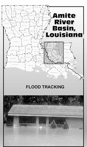
Louisiana Flood Alert
Flooding is a severe perennial problem in Louisiana. Anything USGS can do to alleviate problems associated with flooding is quickly incorporated into the thinking and actions of elected officials. USGS participated as a key team player in Louisiana's hurricane preparedness drill on June 18. All State and Federal agencies that would respond to a hurricane coming ashore in Louisiana participated in the drill, which is held annually in the Louisiana Office of Emergency Preparedness (LOEP) Emergency Operations Center. These agencies included the Federal Emergency Management Agency, the National Weather Service, the U.S. Army Corps of Engineers, USGS, LOEP, Louisiana State Police, Louisiana Department of Transportation and Development, and Red Cross. At various times, USGS staff projected onto the main, large-scale screen, maps of gaging stations in the affected area of an imaginary hurricane. This was followed by graphs of the typical data available from these stations, including stage, rainfall, wind speed and direction, and conductivity. USGS has in place at LOEP's Emergency Operations Center a self-contained satellite downlink system with associated computers that can operate using the power from LOEP's emergency generators. In the event of a real hurricane, USGS personnel would staff the Center, and relay directly to State emergency officials real-time hydrologic information from the USGS Louisiana HydroWatch network.
In addition to participating in the hurricane preparedness drill, in FY 1998 USGS revised a previously published flood tracking chart for the Amite River Basin to include stations added to the flood-monitoring network in the basin since the original publication. Display holders have been filled and are being placed in all public libraries and Welcome Centers within the basin, and in the Governor's Office. The USGS real-time flood alert systems and the mass distribution of the flood tracking chart and associated information on flooding, as well as many other community activities, have helped secure a 15-percent decrease in flood-insurance rates for communities in flood-prone areas. To facilitate citizens' use of the charts, State and local agencies who cooperate with USGS are considering the placement of signs marking the locations of flood-alert monitoring stations.
Volcano Hazards
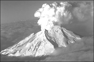
Redoubt Volcano
|
Expansion of Alaskan Monitoring to Improve Aviation Safety -- With funding provided by the Federal Aviation Administration (FAA) in FY 1996, FY 1997, and FY 1998, the Alaskan Volcano Observatory (AVO) has successfully expanded its monitoring of Alaskan volcanoes. These include several Central Aleutian volcanoes whose eruptions can produce volcanic-ash clouds highly damaging to aircraft in the heavily traveled airways across the North Pacific. The monitoring expansion will bring to 18 the number of volcanoes that are seismically monitored in real time by the AVO. Volcanic ash erupted into the high atmosphere is highly hazardous to modern high-performance jet aircraft because it erodes compressor blades, melts onto critical engine parts, and causes loss of engine power. Hazardous concentrations of volcanic ash can drift at air-traffic altitudes for hundreds to thousands of
miles downwind following a volcanic eruption. Worldwide, about 80 jet aircraft in the last 15 years have accidentally entered volcanic-ash clouds, putting thousands of passengers at risk. Using data from its monitoring networks, AVO provides eruption reports and prognoses of future activity to the National Weather Service (NWS), the FAA, and the aviation industry. The NWS uses USGS information to help track eruption clouds, and the FAA uses the USGS and NWS information to route air traffic away from dangerous ash clouds.
Landslide Hazards
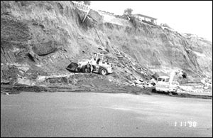
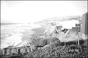
Landslide Hazards Associated with El Niño Weather Effects -- The USGS is contributing valuable information regarding the potential for landslide occurrences associated with El Niño weather effects by combining its computerized national landslide susceptibility map with national climate outlook maps produced by National Oceanic and Atmospheric Administration (NOAA). The distribution of El Niño-induced precipitation and temperature anomalies for 1997-1998 were predicted by NOAA's maps. This combination of USGS and NOAA information indicates where and when rainfall- and
snowmelt-induced landsliding could occur. This information was frequently updated and refined and made available on the Internet at http://landslides.usgs.gov/, and indicated broad regions of the Nation that had increased potential for landslides during the El Niño climatic episode.
|
|
|
El Niño related landslides along the California coast.
|
Operational Flood Simulation System Development for Du Page County, Illinois
Development of a near real-time operational flood simulation system has and will improve the hydrologic information available in Du Page County, Illinois, for issuing flood warnings and optimizing the operation of the Elmhurst Quarry Flood Control Reservoir. The project has two major components: (1) installation and operation of a comprehensive rain-gage network that will provide real-time rainfall data, and (2) development of a near real-time flood-simulation system. The objectives for the second component are: (1) simplify and interface computer models of the Salt Creek watershed into a near real-time flood-simulation system that is more robust and easier to use; (2) test the modified models; and (3) integrate the models with the data-retrieval and
analysis systems being developed for the rain-gage network, to ensure that the models are user-friendly and produce timely results. Appreciable progress has been made on the two major project components during FY 1998. The rain-gage network is fully operational. The stand-alone simulation system is functional, and documentation is in preparation. The data input interface has been reviewed and enhanced. When it is completed, this system will increase the efficiency of all
Du Page hydrologic and hydraulic modeling
applications.
Earth's Magnetic Field -- Geomagnetism
Expanded Observatory Program -- In FY 1998, the USGS Geomagnetism Program entered into a long-term partnership with the Navy and the National Imagery and Mapping Agency (NIMA) to provide these agencies and the Department of Defense (DOD) with critical geomagnetic data. The DOD agencies and NIMA require specific models of the Earth's magnetic field for navigation and for other purposes. New sources of crucial geomagnetic data, particularly from the ocean area of the world are needed to make these models. This partnership will enable the program to establish completely instrumented geomagnetic observatories in oceanic regions of the world, especially in the southern hemisphere, areas from which no continuous geomagnetic data are currently available. The data from these "critical gaps" in the present coverage will be the basis for the long-term modeling and charting activities that will provide the 5-year geomagnetic models to our partners in 2001.
USGS Magnetic Observatory locations
|
PREVIOUS || TABLE OF CONTENTS || NEXT
This page is https://pubs.usgs.gov/98financial/hazards.html
Maintained by Eastern Publications Group Web Team
Last updated July 6, 1999