Bulletin 2201-A
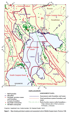
This report was prepared as part of the World Energy Project of the U.S. Geological Survey. In the project, the world was divided into 8 regions and 937 geologic provinces. The provinces have been ranked according to the discovered oil and gas volumes within each (U.S. Geological Survey World Energy Assessment Team, 2000). Then, 76 “priority” provinces (exclusive of the U.S. and chosen for their high ranking) and 26 “boutique” provinces (exclusive of the U.S. and chosen for their anticipated petroleum richness or special regional economic importance) were selected for appraisal of oil and gas resources. The petroleum geology of these priority and boutique provinces is described in this series of reports. Four total petroleum systems (TPS) have been identified in the basin. The South Mangyshlak TPS contains more than 40 discovered fields. The principal reserves are in Lower–Middle Jurassic sandstone reservoirs in structural traps. Source rocks are poorly known, but geologic data indicate that they are in the Triassic taphrogenic sequence. Migration of oil and gas significantly postdated maturation of source rocks and was related to faulting and fracturing during middle Miocene to present time. A single assessment unit covers the entire TPS. Largest undiscovered resources of this assessment unit are expected in the largely undrilled offshore portion of the TPS, especially on the western plunge of the Mangyshlak meganticline. The Terek-Caspian TPS occupies the fold-and-thrust belt, foredeep, and adjoining foreland slope. About 50 hydrocarbon fields, primarily oil, have been discovered in the TPS. Almost all hydrocarbon reserves are in faulted structural traps related to thrusting of the foldbelt, and most traps are in frontal edges of the thrust sheets. The traps are further complicated by plastic deformation of Upper Jurassic salt and Maykop series (Oligocene– lower Miocene) shale. Principal reservoirs are fractured Upper Cretaceous carbonates and middle Miocene sandstones. Principal source rocks are organic-rich shales in the lower part of the Maykop series. Source rocks may also be present in the Eocene, Upper Jurassic, and Middle Jurassic sections, but their contribution to discovered reserves is probably small. Three assessment units are delineated in the TPS. One of them encompasses the thrust-and-fold belt of northern Caucasus foothills. This assessment unit contains most of the undiscovered oil resources. The second assessment unit occupies the foredeep and largely undeformed foreland slope. Undiscovered resources of this unit are relatively small and primarily related to stratigraphic traps. The third unit is identified in almost untested subsalt Jurassic rocks occurring at great depths and is speculative. The unit may contain significant amounts of gas under the Upper Jurassic salt seal. The Stavropol-Prikumsk TPS lies north of the Terek-Caspian TPS and extends offshore into the central Caspian Sea where geologic data are scarce. More than one hundred oil and gas fields have been found onshore. Offshore, only one well was recently drilled, and this well discovered a large oil and gas field. Almost the entire sedimentary section of the TPS is productive; however, the principal oil reserves are in Lower Cretaceous clastic reservoirs in structural traps of the Prikumsk uplift. Most original gas reserves are in Paleogene reservoirs of the Stavropol arch and these reservoirs are largely depleted. At least three source rock formations, in the Lower Triassic, Middle Jurassic, and Oligocene–lower Miocene (Maykop series), are present in the TPS. Geochemical data are inadequate to correlate oils and gases in most reservoirs with particular source rocks, and widespread mixing of hydrocarbons apparently took place. Three assessment units encompassing the onshore area of the TPS, the offshore continuation of the Prikumsk uplift, and the central Caspian area, are identified. The principal portion of undiscovered resources is assigned to the offshore Prikumsk zone where a large discovery was recently made (after this resource assessment had been completed). The Shakpakhty TPS is small and located east of the South Mangyshlak subbasin. The TPS contains a single gas field, possesses very low potential, and has not been assessed. |
Version 1.0 Posted June 2001
Available Chapters for B 2201
|
