Bulletin 2201-B
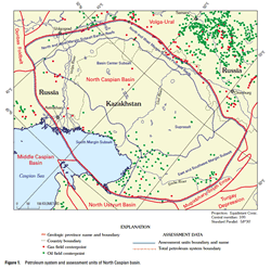
The North Caspian basin is a petroleum-rich but lightly explored basin located in Kazakhstan and Russia. It occupies the shallow northern portion of the Caspian Sea and a large plain to the north of the sea between the Volga and Ural Rivers and farther east to the Mugodzhary Highland, which is the southern continuation of the Ural foldbelt. The basin is bounded by the Paleozoic carbonate platform of the Volga-Ural province to the north and west and by the Ural, South Emba, and Karpinsky Hercynian foldbelts to the east and south. The basin was originated by pre-Late Devonian rifting and subsequent spreading that opened the oceanic crust, but the precise time of these tectonic events is not known. The sedimentary succession of the basin is more than 20 km thick in the central areas. The drilled Upper Devonian to Tertiary part of this succession includes a prominent thick Kungurian (uppermost Lower Permian) salt formation that separates strata into the subsalt and suprasalt sequences and played an important role in the formation of oil and gas fields. Shallowshelf carbonate formations that contain various reefs and alternate with clastic wedges compose the subsalt sequence on the 2 Petroleum Geology, Resources—North Caspian Basin, Kazakhstan and Russia basin margins. Basinward, these rocks grade into deep-water anoxic black shales and turbidites. The Kungurian salt formation is strongly deformed into domes and intervening depressions. The most active halokinesis occurred during Late Permian–Triassic time, but growth of salt domes continued later and some of them are exposed on the present-day surface. The suprasalt sequence is mostly composed of clastic rocks that are several kilometers thick in depressions between salt domes. A single total petroleum system is defined in the North Caspian basin. Discovered reserves are about 19.7 billion barrels of oil and natural gas liquids and 157 trillion cubic feet of gas. Much of the reserves are concentrated in the supergiant Tengiz, Karachaganak, and Astrakhan fields. A recent new oil discovery on the Kashagan structure offshore in the Caspian Sea is probably also of the supergiant status. Major oil and gas reserves are located in carbonate reservoirs in reefs and structural traps of the subsalt sequence. Substantially smaller reserves are located in numerous fields in the suprasalt sequence. These suprasalt fields are largely in shallow Jurassic and Cretaceous clastic reservoirs in salt dome-related traps. Petroleum source rocks are poorly identified by geochemical methods. However, geologic data indicate that the principal source rocks are Upper Devonian to Lower Permian deep-water black-shale facies stratigraphically correlative to shallow-shelf carbonate platforms on the basin margins. The main stage of hydrocarbon generation was probably in Late Permian and Triassic time, during deposition of thick orogenic clastics. Generated hydrocarbons migrated laterally into adjacent subsalt reservoirs and vertically, through depressions between Kungurian salt domes where the salt is thin or absent, into suprasalt clastic reservoirs. Six assessment units have been identified in the North Caspian basin. Four of them include Paleozoic subsalt rocks of the basin margins, and a fifth unit, which encompasses the entire total petroleum system area, includes the suprasalt sequence. All five of these assessment units are underexplored and have significant potential for new discoveries. Most undiscovered petroleum resources are expected in Paleozoic subsalt carbonate rocks. The assessment unit in subsalt rocks with the greatest undiscovered potential occupies the south basin margin. Petroleum potential of suprasalt rocks is lower; however, discoveries of many small to medium size fields are expected. The sixth identified assessment unit embraces subsalt rocks of the central basin areas. The top of subsalt rocks in these areas occurs at depths ranging from 7 to 10 kilometers and has not been reached by wells. Undiscovered resources of this unit did not receive quantitative estimates. |
Version 1.0 Posted 2001
Available Chapters for B 2201
|
