Bombay Geologic Province Eocene to Miocene Composite Total Petroleum System, India
By C.J. Wandrey
Petroleum Systems and Related Geologic Studies in Region 8, South Asia
Edited by Craig J. Wandrey
Figure 1 Preview
Link to Report PDF (5.7 MB)
Right-Click to 'Save As' or 'Download'
Introduction
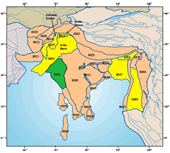
Among the 76 priority geologic provinces identified for the World Energy Assessment Project of the U.S. Geological Survey is the Bombay geologic province (province 8043), which is an oil-prone area, both onshore and offshore. The Bombay geologic province is bounded on the north by the Nagar-Parkar Ridge, on the east by the Precambrian Vindhyan Plateau and Deccan Syncline, on the south by the Vengurla Arch and on the west by the 2,000-m bathymetric contour. The area includes the outer shelf of western India, much of which is referred to as the Bombay Shelf; Bombay High; Dahanu, Panna, and Surat Depressions; Cambay and Narmada Deltas; Cambay and Kutch Grabens; and Saurashtra or Kathiaw Peninsula.
Structurally, the province consists of a deformed and rifted portion of the western Indian plate passive margin. Significant features include the uplifted structures of the Bombay High and...>>MORE