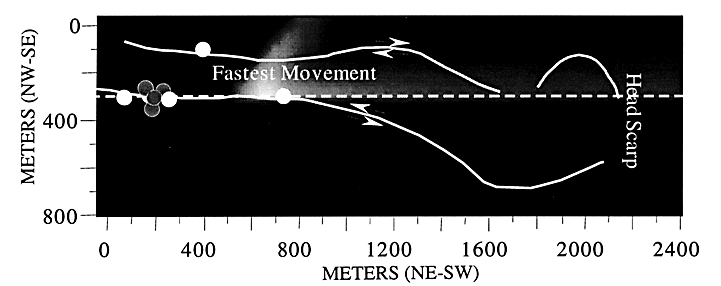
Figure 5.-- A map-view distribution of slidequake source location probability confidence levels at the ground surface (denoted by shading; the whitest shading indicates the most probable location). We assume a velocity structure that varies only in the lateral direction and that observed signals are surface waves traveling along straight-line trajectories between the source and seismic station. The shear (or group) velocity northwest of the dashed line is 0.286 km/sec and is 3.600 km/sec to the southeast. Circles indicate seismic stations (white, analog; gray, digital), and the white curved lines delineate the outline of the active slide. The distribution of probability confidence levels is calculated using a grid-search algorithm (Tarantola and Valette, 1982; Gomberg and others, 1989). The validity of the model and location algorithm is demonstrated by locating four explosions, and noting that their true locations are within their respective 90 percent confidence intervals, with the most probable locations being in error by <30 m. Results are insensitive to reasonable changes in model velocities.

![]() U.S. Department of the Interior |
U.S. Geological Survey
U.S. Department of the Interior |
U.S. Geological Survey
URL: http://pubsdata.usgs.gov/pubs/bul/b2130/ch14fig5.htm
Page Contact Information: GS Pubs Web Contact
Page Last Modified: Friday, 23-Mar-2012 14:25:15 EDT