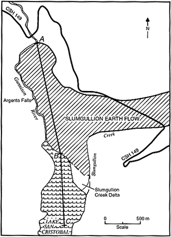
Figure 5.-- Outline map of the lower end of the Slumgullion earth flow and the blockage of the Lake Fork of the Gunnison River. Line ABC indicates the approximate location of the pre-landslide Lake Fork of the Gunnison River. CSH, Colorado State Highway.

![]() U.S. Department of the Interior |
U.S. Geological Survey
U.S. Department of the Interior |
U.S. Geological Survey
URL: http://pubsdata.usgs.gov/pubs/bul/b2130/ch6fig5.htm
Page Contact Information: GS Pubs Web Contact
Page Last Modified: Friday, 23-Mar-2012 14:25:05 EDT