This report was prepared as part of the World Energy Project of the U.S. Geological Survey. For this project, the world was divided into 8 regions and 937 geologic provinces, which were then ranked according to the known oil and gas volumes within each (U. S. Geological Survey World Energy Assessment Team, 2000). Of these, 76 "priority" provinces (exclusive of the United States and chosen for their high ranking) and 26 "boutique" provinces (exclusive of the United States and chosen for their anticipated petroleum richness or special regional economic importance) were selected for appraisal of oil and gas resources. The petroleum geology of these priority and boutique provinces is described in this series of reports.
The purpose of the World Energy Project is to assess the quantities of oil, gas, and natural gas liquids that have the potential to be added to reserves within the next 30 years. These volumes either reside in undiscovered fields whose sizes exceed the stated minimum-field-size cutoff value for the assessment unit (variable, but must be at least 1 million barrels of oil equivalent) or occur as reserve growth of fields already discovered.
The total petroleum system constitutes the basic geologic unit of the oil and gas assessment. The total petroleum system includes all genetically related petroleum that occurs in shows and accumulations (discovered and undiscovered) that (1) has been generated by a pod or by closely related pods of mature source rock, and (2) exists within a limited mappable geologic space, along with the other essential mappable geologic elements (reservoir, seal, and overburden rocks) that control the fundamental processes of generation, expulsion, migration, entrapment, and preservation of petroleum. The minimum petroleum system is that part of a total petroleum system encompassing discovered shows and accumulations along with the geologic space in which the various essential elements have been proved by these discoveries.
An assessment unit is a mappable part of a total petroleum system in which discovered and undiscovered fields constitute a single, relatively homogeneous population such that the chosen methodology of resource assessment based on estimation of the number and sizes of undiscovered fields is applicable. A total petroleum system may equate to a single assessment unit, or it may be subdivided into two or more assessment units if each unit is sufficiently homogeneous in terms of geology, exploration considerations, and risk to assess individually.
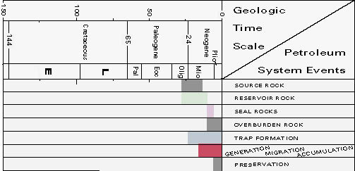
A graphical depiction of the elements of a total petroleum system is provided in the form of an events chart that shows the times of (1) deposition of essential rock units; (2) trap formation; (3) generation, migration, and accumulation of hydrocarbons; and (4) preservation of hydrocarbons.
A numeric code identifies each region, province, total petroleum system, and assessment unit; these codes are uniform throughout the project and will identify the same type of entity in any of the publications. The code is as follows:
Region, single digit 4
Province, three digits to the right of
region code 4068
Total petroleum system, two digits to
the right of province code 406801
Assessment unit, two digits to the
right of petroleum system code 40680101
The codes for the regions and provinces are listed in U.S. Geological Survey World Energy Assessment Team (2000).
Oil and gas reserves quoted in this report are derived from Petroconsultants' Petroleum Exploration and Production database (Petroconsultants, 1996) and other area reports from Petroconsultants, Inc., unless otherwise noted.
The figure in this report that shows boundaries of the total petroleum system and assessment units was compiled using geographic information system (GIS) software. Political boundaries and cartographic representations were taken, with permission, from Environmental Systems Research Institute's ArcWorld 1:3 million digital coverage (1992), have no political significance, and are displayed for general reference only.
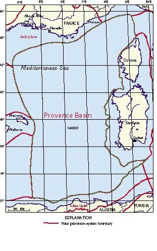
The Provence Basin is in that portion of the western Mediterranean Sea that is deeper than 2 kilometers. The basin lies essentially beyond the outer continental shelf, between the countries of France, Italy, and Algeria, the Balearic Islands, and the islands of Sardinia and Corsica. It encompasses nearly 300,000 square kilometers and includes the Rhone River submarine fan on the continental slope of southern France. It is province 4068 in the World Energy study.
A single, hypothetical, total petroleum system (TPS), the Pre-Messinian TPS (406801), was described for the Provence Basin. The designation hypothetical is used because there is no hydrocarbon production from the basin. The Provence Basin is a deep-water Tertiary rift basin in which the geothermal gradients vary regionally. The Red Sea Basin shares a similar geologic and thermal history with the rifted western Mediterranean Sea and was used as an analog to better understand the genesis of the Provence Basin and as a guide to estimating possible undiscovered amounts of hydrocarbons.
For this assessment the basin was given a potential, at the mean, for undiscovered resources of 51 trillion cubic feet (1.4 trillion cubic meters) gas, 0.42 billion barrels oil, and 2.23 million barrels natural gas liquids.
The Provence Basin is a Tertiary rift basin located entirely offshore in the western Mediterranean Sea (fig. 1). Although the deep basin is a flat sea floor, it includes the Rhone River submarine fan deposited onto and beyond the continental slope off southern France. The central part of the basin is believed to contain a 3—4 km thickness of pre-Messinian age turbidite and pelagic sediments overlain by a 1—2 km thick sequence of Messinian (uppermost Miocene) evaporites. A Pliocene and Pleistocene pelagic sediment and turbidite cover is estimated to add another 1—2 km in thickness (fig. 2).
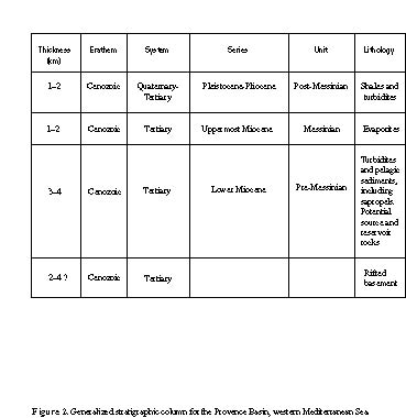
Figure 2. Generalized stratigraphic column for the Provence Basin, western Mediterranean Sea.
The basin as described contains one hypothetical TPS, the Pre-Messinian TPS (406801). No data exist on drilling, production, or oil chemistry that would support the existence or even the possibility of hydrocarbon generation by source rocks. However, all other essential geologic elements of reservoir, seal, and overburden rocks that control the fundamental processes of generation, expulsion, migration, entrapment, and preservation of petroleum in a petroleum system are believed to exist.
A TPS was defined for this location using a geologic analog, and hydrocarbon resources were assigned based on that analog. That precise lithology and thickness of the subsalt sediments are unknown necessitated, in the assessment process, use of a high risk factor for hydrocarbon charge, to limit the confidence of finding any hydrocarbons. The basin is considered to be a potential gas province with limited oil prospects.
The Red Sea Basin (Lindquist, 1999) shares a number of geologic similarities with the Provence Basin. Both are products of tectonic activity in the Oligocene to Miocene, both are rift basins with attenuated continental crusts, and both have poorly understood variable heat flow from the basement. The two basins have extensive evaporite deposits and salt domes. The differences are also significant: the Red Sea Basin is a proven oil and gas producer, whereas the Provence Basin presently has no production. Much remains to be learned about the Provence Basin.
The TPS boundary coincides with the province boundary (fig. 1). It is drawn on or near the base of the continental slopes of France, Algeria, Corsica, Sardinia, and the Balearic Islands. The Rhone River submarine fan, which covers the continental slope offshore southern France, is included. The southwestern portion of the western Mediterranean between Africa and the Balearic Islands is not included.
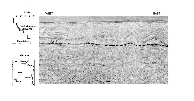
The break-up of Pangea was initiated during Late Triassic, and crustal separation between the Eurasian and Afro-Arabian continents occurred in Jurassic time, creating the Tethys seaway. The two continental blocks converged during the Cretaceous and early Cenozoic, resulting in continental shortening and mountain building by stacking; by the end of the Eocene, the Tethys seaway had nearly disappeared. In the Oligocene the convergence direction between Africa and Eurasia was altered by north-south compression and dextral oblique slip due to the spreading of the North Atlantic Ocean. By late Eocene to early Miocene time, the initial rifting which was to form the western Mediterranean had occurred. The islands of Corsica and Sardinia were rotated counterclockwise away from the European continent, creating the Gulf of Lion south of France. In the middle and late Miocene, the Provence Basin formed, as seafloor spreading progressed, with 2—4 km of a distinct syn-rift rock sequence developing. Evident on seismic sections (fig. 3), the post-rift sequence is composed of sandy shales, overlain by a distinct unconformity (Cravatte and others, 1974). The sequence is dominated by clastics and includes lower Miocene shales and sandstones from turbidites (Burrus and Audebert, 1990; Hsü and others, 1978). Evaporite deposition, which included anhydrite, halite and potash, occurred: as much as 2 km was deposited in the deep basin; carbonates were deposited in shallower regions. During the Messinian of uppermost Miocene, the Mediterranean was closed off to open-marine circulation; excessive evaporation created a major regression that exposed the entire Mediterranean margin to erosion. During the Pliocene and Pleistocene, the seas returned to the Mediterranean region, ending evaporite deposition. Overlying the evaporites is a Pliocene and Quaternary shale and turbidite sequence. Subsidence of the basin continues today and is believed to result from cooling of the oceanic lithosphere and (or) from sediment loading (Biju-Duval and others, 1978).
The deep Provence Basin (>2.5 km) has not been explored for petroleum because current technology limits deep-sea exploration to about 2 km water depth. The shelf area of the Gulf of Lion has been drilled with limited success, with some production ongoing in the near offshore. DSDP leg 42A (Kidd and others, 1978) drilled several holes through thin salt deposits on the perimeter of the basin. DSDP drilling legs 13 (1973) and 42A (Kidd and others, 1978) penetrated interbedded evaporites (anhydrite and gypsum) and dolomitic marls. Concern about drilling into the thicker deposits without blowout prevention equipment precluded further drilling.
For the World Energy 2000 Assessment, the Provence Basin was assessed as one hypothetical TPS, the Pre-Messinian (406801), with one assessment unit, the Subsalt AU (40680101) (fig.1). The presence of hydrocarbons is speculative. Within the TPS no hydrocarbons have been located. Seeps are not known.
The entire pre-Messinian stratigraphic section is expected to contribute to the eventual production of gas and oil (figs. 2, 3). The block-faulted region above and including the basement should be the most favorable location in the basin for gas. All of the pre-Messinian subsalt section is possibly within the maturation window for gas. Because of the different geothermal gradients involved, disparities in generation on both local and subregional scales may exist, such that mature source rock may be localized as separate pods. The distribution, quantity, and quality of the organic matter in the sediments will also have a significant effect on any generation and type of hydrocarbon product. It is possible that biogenic gas will make up a portion of the anticipated hydrocarbons from this province.
Salt diapirs are present at the bottom of the Rhone River submarine fan slope and along the west side of the province boundary. Such structures are well known to be excellent hydrocarbon traps. Beneath the evaporite layer, the conditions to generate and trap hydrocarbons could exist within any part of the stratigraphic column.
Organic-rich sediments have been described from several locations in the Mediterranean. Nesteroff (1973), Kidd and others (1978), and Sigl and others (1978) have described sapropels, or organic-rich muds, from the eastern Mediterranean. Kidd and others (1978) provided a working definition for sapropel: "a discrete layer greater than 1 cm in thickness, set in open marine pelagic sediments and containing greater than 2.0 percent organic carbon by weight" (p. 422). Sapropels are thought to be deposited under euxinic bottom conditions corresponding to stagnant phases of a basin. Miocene to Pleistocene age piston core samples collected during DSDP leg 42A from the eastern Mediterranean Sea, southeast, south, and southwest of Greece, and just west of Cyprus, contained kerogen which ranged as high as 5 percent in layers 1—3 cm thick (Deroo and others, 1978). Nesteroff (1973) also described Quaternary-age turbidites containing sapropels from the eastern Mediterranean Sea south of Greece. These samples contained kerogen in concentrations as high as 5 percent. Although sapropels have not been found in the western Provence Basin, sampling has yet to penetrate the thick Messinian evaporites.
Sediment accumulation is generally facilitated by proximity to sources, and thicker, richer source rocks are often deposited closer to the continental slope. At the basin center, farther from a sediment source, the rocks would most likely be fine-grained pelagic deposits, although turbidites can reach long distances onto the abyssal plain. Richards and others (1998) noted that mud-rich submarine fans, one constituent of a range of deep-marine clastic systems, have a high transport efficiency and can have a transport radius of as much as 3,000 km. The efficiency drops with increasing sediment grain size.
Source rocks for the Provence Basin could be any or all of the following: turbidite sequences, pelagic sediments, or carbonate rocks. Of these rock/facies types, turbidites seem to offer the best source rock possibilities (Pettingill, 1998a, b). Pelagic sediments are not known to be prolific oil and gas generators; their potential in the Provence Basin remains to be established. Carbonate rocks can be good source rocks, but their potential is highly variable.
Stratigraphically, source rocks could occur over the entire pre-Messinian sedimentary column. Syn-rift sedimentation may incorporate source material for hydrocarbon generation. Geophysical profiles show grabens with thick accumulations of sediment next to grabens that appear to be starved of sediment. Episodic sedimentation would suggest an unequal distribution of any type rock, at least, within the block-faulted basement.
Without yet being identified, reservoirs (or potential ones) can be expected geographically nearly anywhere throughout the basin. One prospective situation is within the southwest-northeast-trending basement fault blocks, which extend over a large part of the basin.
The 1—2 km thick Messinian evaporites overlain by a 1—2 km thick post-Messinian sediment column constitute a significant portion of the overburden throughout the basin; no specific rock unit can be described (figs. 2, 3). Additionally, the thickest part of the Pliocene and Pleistocene is in the northern part of the basin associated with the Rhone River fan. The evaporite cover probably has a greater thickness towards the middle of the basin and thins towards the basin margins. The overburden is apparently the Messinian salt plus the post-Messinian turbidites.
The sediments beneath the evaporite cover are estimated to be as much as 4 km thick. Combined with the 2—4 km of Messinian and post-Messinian sediments, overburden alone is sufficient to raise the thermal maturity of the pre-evaporite rocks into the oil, or perhaps, gas window. This may be dependent on location. Burrus and Foucher (1986) showed that the geothermal gradient as sampled throughout the entire basin is highly variable, in a range of from 46° to 95°C/km, and increases from northwest in the Gulf of Lion to southeast at Sardinia. This variation is believed to be due to an asymmetrical distribution in the subcrustal heat flow, which, in turn, may be the result of magmatic activity. Burrus and Audebert (1990) believed that deposition of the low-permeability Messinian evaporites caused an undercompaction of the subsalt shales that then would have a lower thermal diffusivity and thus higher temperatures. This would increase the possibility of the pre-Messinian shales becoming a hydrocarbon source. The evaporites, despite their high thermal conductivity, along with the post-Messinian sediments and the higher geothermal gradient, should provide sufficient cover to allow the thermal maturity of the shales to progress in a relatively short time. Most if not all of the sediment thickness is expected to be within the generative window for gas, and locally, oil.
Two obvious migration paths are (1) vertical, along the fault planes in the basement and near-basement; and (2) both lateral and vertical through porous facies and possibly syn-depositional slumps in the essentially flat lying rocks above the basement faulting.
Traps are expected to be present over much of the block-faulted basement. Formed during crustal attenuation and rifting, faults are expected to form the most common and largest traps in the basin. These horst and graben structures extend across the basin and were covered or sealed by post-rift sedimentation. Within the post-rift sediments, stratigraphic and facies changes are expected to be the prevalent trap style. There is no way to estimate the volume, extent, or closure of these traps, which will vary laterally, and vertically depending on their extent and depositional environment. The timing of trap development is early Miocene through the present.
Without question the 1—2 km thick Messinian evaporites form an extraordinary seal that appears to blanket the entire basin. Below the evaporites hydrocarbon seals may exist but are less obvious on either a small or a large scale. Smaller scale salt or evaporite layers may also occur within the pre-Messinian sediments. Some shale units within predominantly pelagic sediments and within turbidites are also expected to act as seals.
Reservoir rocks are expected to be sandstones. Turbidites commonly contain sandstone bodies along the margins of the basin, along the continental slope, and perhaps into the center of the basin. Frequency and size of carbonate reservoirs are probably secondary to those of sandstone reservoirs.
One AU, summarized in figure 4, Subsalt AU (40680101), was identified for the Provence Basin. It encompasses the entire sedimentary column beneath the Messinian evaporite cover. The basin is considered to be nearly exclusively a gas province with very little potential for oil. With a risk factor that severely limits the probability of resources, the AU was estimated to contain, at the mean, undiscovered resources of 51 trillion cubic feet of gas, 0.42 billion barrels oil, and 2.23 million barrels natural gas liquids.
Biju-Duval, B., Letouzey, J., and Montadert, Lucien, 1978, Variety of margins and deep basins in the Mediterranean, in Watkins, J.S., Montadert, Lucien, and Dickerson, P.W., eds., Geological and geophysical investigations of continental margins: American Association of Petroleum Geologists Memoir 29, p. 293—318.
Burrus, J., and Foucher, J.P., 1986, Contribution to the thermal regime of the Provencal Basin based on flumed heat flow surveys and previous investigations: Tectonophysics, v. 128, p. 303—334.
Burrus, Jean, and Audebert, Francois, 1990, Thermal and compaction processes in a young rifted basin containing evaporates—Gulf of Lions, France: American Association of Petroleum Geologists Bulletin, v. 74, p. 1420—1440.
Cravatte, J., Dufaure, P., Prim, M., and Rouaix, S., 1974, Les sondages du Golfe du Lion, stratigraphie et sedimentologie: Notes Memoir, v. 2, p. 209—274.
Deroo, G., Herbin, J.P., and Roucache, J., 1978, Organic geochemistry of some Neogene cores from sites 374, 375, 377 and 378; leg 42A, eastern Mediterranean Sea, sedimentology and environmental conditions of sapropels, in
Hsü, K.J., Montadert, Lucien, and others, eds., Initial reports of the Deep-Sea Drilling Project, Volume XLII, part 1: Washington, D.C., U.S. Government Printing Office, p. 465—472.
Environmental Systems Research Institute Inc., 1992, ArcWorld 1:3M digital database: Environmental Systems Research Institute, Inc. (ESRI), available from ESRI, Redlands, Calif., scale 1:3,000,000.
Finetti, I., and Morelli, C., 1973, Geophysical exploration of the Mediterranean Sea: Bollettino di Geofisica Teorica ed Applicata, v. XV, p. 263—344.
Hsü, K.J., Montadert, Lucien, Bernoulli, Daniel, Cita, M.B., Erickson, Albert, Garrison, R.E., Kidd, R.B., Melieres, Frederic, Müller, Carla, and Wright, Ramil, 1978, History of the Mediterranean salinity crisis, in Hsü, K.J., Montadert, Lucien, and others, eds., Initial reports of the Deep-Sea Drilling Project, Volume XLII, part 1: Washington, D.C., U.S. Government Printing Office, p. 1053—1079.
Kidd, R.B., Cita, M.B., and Ryan, W.B.F., 1978, Stratigraphy of eastern Mediterranean sapropels sequences recovered during DSDP Leg 42A and their paleoenvironmental significance, in Hsü, K.J., Montadert, Lucien, and others, eds., Initial reports of the Deep Sea Drilling Project, Volume XLII, part 1: Washington, D.C., U.S. Government Printing Office, p. 421—443.
Lindquist, S.J., 1999, The Red Sea Basin province—Sudr-Nubia and Maqna petroleum systems: U.S. Geological Survey Open-File Report 99—50—A.
Nesteroff, W.D., 1973, Petrography and mineralogy of sapropels, in Ryan, W.B.F., Hsü, K.J., and others, eds., Initial reports of the Deep-Sea Drilling Project, Volume XIII:Washington, D.C., U.S. Government Printing Office, p. 713—720.
Petroconsultants, 1996, Petroleum exploration and production database: Petroconsultants, Inc., Houston, TX 77274-0619, U.S.A., or Petroconsultants, Inc., Geneva, Switzerland.
Pettingill, H.S., 1998a, World Turbidites—1& 2—Turbidite plays' immaturity means big potential remains: Oil and Gas Journal, October 5, p. 106—112.
Pettingill, H.S., 1998b, World Turbidites—1& 2—Turbidite plays' immaturity means big potential remains: Oil and Gas Journal, October 12, p. 93—97.
Richards, M., Bowman, M., and Reading, H., 1998, Submarine-fan systems 1—Characterization and stratigraphic prediction: Marine and Petroleum Geology, v. 15, no. 7, p. 689—717.
Sigl, Walter, Chamley, Herve, Fabricius, Frank, Giroud d'Argoud, Ghislaine, and Muller, Jens, 1978, Sedimentology and environmental conditions of sapropels, in Initial reports of the Deep-Sea Drilling Project, Volume XLII, part 1: Washington, D.C., U.S. Government Printing Office, p. 445—465.
U.S. Geological Survey World Energy Assessment Team, 2000, U.S. Geological Survey world petroleum assessment 2000—Description and results: U.S. Geological Survey Digital Data Series DDS-60, 4 CD-ROMs. Published in the Central Region, Denver, Colorado Manuscript approved for publication November 18, 2003 Graphics by Mark Pawlewicz Photocomposition by William SowersEdited by L. M. Carter
Document Accessibility: Adobe Systems Incorporated has information about PDFs and the visually impaired. This information provides tools to help make PDF files accessible. These tools convert Adobe PDF documents into HTML or ASCII text, which then can be read by a number of common screen-reading programs that synthesize text as audible speech. In addition, an accessible version of Acrobat Reader 6.0, which contains support for screen readers, is available. These tools and the accessible reader may be obtained free from Adobe at Adobe Access.
| AccessibilityFOIAPrivacyPolicies and Notices | |
| |
|