Southwest Geographic Science Center
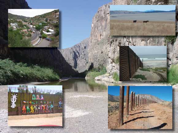
Images of the U.S.-Mexico border. Central photo: Stretch of the Rio Grande drying up in February 2003 in the Big Bend National Park, Texas (USGS photo by John Klein). Insert photos (clockwise from upper right): (1) Rangelands looking south into Mexico from the eastern edge of the San Rafael Valley, south of the Huachuca Mountains, Arizona (USGS photo by Bruce Gungle); (2) border fencing at California coast (photo by Chris Lukinbeal, Arizona State University); (3) vehicle barrier, Coronado National Memorial at the International Boundary with Mexico ((USGS photo by Bruce Gungle); (4) artwork on the border wall at Nogales, Sonora, Mexico (photo by Gigi Owen, University of Arizona); (5) view from Castlerock of street and houses in colonia of historic Bisbee, Arizona (USGS photo by Laura Norman).
Competition for water resources, habitats, and urban areas in the Borderlands has become an international concern. In the United States, Department of Interior Bureaus, Native American Tribes, and other State and Federal partners rely on the U.S. Geological Survey (USGS) to provide unbiased science and leadership in the Borderlands region. Consequently, the USGS hosted a workshop, “Facing Tomorrow’s Challenges along the U.S.-Mexico Border,” on March 20–22, 2007, in Tucson, Ariz., focused specifically on monitoring, modeling, and forecasting change within the Arizona-Sonora Transboundary Watersheds
Introduction to the Workshop Proceedings by Laura M. Norman, Derrick D. Hirsch, and A. Wesley Ward
The U.S.-Mexico Field Coordinating Committee—Who We Are and What We Do by Diana M. Papoulias
Interdisciplinary Science in Support of Environmental Health Along the U.S.-Mexico Border—Using Map Tools to Understand Linkages Between the Environment and Human Health by Jim Stefanov, Diana M. Papoulias, Jean Parcher, and Ric Page
How an Integrated State-Federal Geoscience Information Network Can Be Applied in the Borderlands by M. Lee Allison and Linda Gundersen
Mapping Surficial Geology in the Border Region of Big Bend National Park, Texas by Margaret E. Berry
Geologic Map Compilation of the U.S.-Mexico Border by Floyd Gray, Jaime Castro Escarrega, and William R. Page
Floodplain Lakes and Their Relation to Alluviation Cycles in the Lower Colorado River by Daniel V. Malmon, Tracey J. Felger, Keith A. Howard
Binational Geologic Mapping in the Lower Rio Grande of Southern Texas, United States, and Northern Tamaulipas, Mexico by William R. Page, Helen Folger, Bernard Hubbard, Jim Stefanov, and Matthew D. Merrill
Lessons Learned from the Salton Sea—Potential Impact of Dust Emission to Both Air Quality and Human Health by Pat Chavez, Jana Ruhlman, Miguel Velasco, Rian Bogle, John Vogel, and JoAnn Isbrecht
Use of Remote Sensing to Detect and Map Temporal and Spatial Vegetation Dynamics to Help Map Landscape Erosion Vulnerability—Mojave Desert and Molokai, Hawaii by Pat Chavez, JoAnn Isbrecht, Miguel Velasco, and Rian Bogle
CHIPS—A New Way to Monitor Colonias Along the U.S.-Mexico Border by Delbert G. Humberson and Jean W. Parcher
An Approach to Prevent Nonpoint-Source Pollutants and Support Sustainable Development in the Ambos Nogales Transboundary Watershed by Laura M. Norman, D. Phillip Guertin, and Mark Feller
The Potential of Binational Land-Cover-Change Detection Procedures for Use along the U.S.-Mexico Border by Zachary D. Wilson and Jean W. Parcher
Comparison of Contemporary Land-Cover Trends Among the Sonoran Basin and Range, Madrean Archipelago, and Chihuahuan Deserts Ecoregions by Jana Ruhlman, Leila Gass, and Barry Middleton
The San Pedro River—A Case Study for Examining Past Landscape Change and Forecasting Hydrological and Biological Response to Urban Growth and Land- Use Change by William G. Kepner, Kenneth G. Boykin, Darius J. Semmens, David C. Goodrich, Christopher J. Watts, and D. Phillip Guertin
Contemporary Digital Land-Cover Mapping for the American Southwest—The Southwest Regional Gap Analysis Project by John Lowry, William G. Kepner, Kenneth G. Boykin, Kathryn A. Thomas, Donald L. Schrupp, and Pat Comer
Stopover Ecology and Habitat Utilization of Migrating Land Birds in Colorado River Riparian Forests of Mexico and the Southwestern United States by Charles van Riper III
Salton Sea Ecosystem—Issues and Status of Restoration Planning by Harvey L. Case, III and Douglas A. Barnum
Geologic Framework, Hydrologic Monitoring, and Land-Use Change in the Willcox and Douglas Basins, Southeast Arizona by James Callegary, Kurt Schonauer, and Alice Konieczki
Automated Geospatial Watershed Assessment (AGWA)—A GIS-Based Hydrologic Modeling Tool for Watershed Assessment and Analysis by D. Phillip Guertin, David C. Goodrich, William G. Kepner, Darius J. Semmens, Mariano Hernandez, Shea Burns, Averill Cate, Lainie Levick and Scott N. Miller
Causes and Consequences of Monsoonal Flooding in Nogales, Sonora by Hans Huth and Dr. Craig Tinney
Sustainability of Water Resources in the Sierra Vista Subwatershed, Arizona—Implications of a Cross-Boundary Aquifer by James M. Leenhouts and Bruce Gungle
Front-Row View of Federal Water Lawmaking Shows Process Works—U.S.-Mexico Transboundary Aquifer Assessment Act Pondered, Passed, and Signed by Sharon Megdal
1. List of Participants
2. Workshop Agenda
Download this report as a 70-page PDF file (c1322.pdf; 22.4 MB)
For questions about the content of this report, contact Laura Norman.
Suggested citation and version history
Download a free copy of the latest version of Adobe Reader.
|
Help |
PDF help |
Publications main page |
| Western Circulars |
| Geography | Western Region Geography
|

![]() U.S. Department of the Interior | U.S. Geological Survey
U.S. Department of the Interior | U.S. Geological Survey
URL: https://pubs.usgs.gov/circ/1322/
Page Contact Information: Michael Diggles
Page Last Modified: April 4, 2008