Occam's razor is defined (Merriam-Webster, 1996) as "a philosophical or scientific principle according to which the best explanation of an event is the one that is the simplest, using the fewest assumptions or hypotheses." Accordingly, explanations of unknown phenomena should be sought first in terms of known quantities. As stated previously, approaches to ground-water-vulnerability assessments are determined by objectives and resources available with tradeoffs among scale, process, objectivity, and complexity. In considering these tradeoffs, a ground-water-vulnerability assessment must maintain impartiality and objectivity commensurate with a reproducible, scientifically defensible product that includes appropriate levels of complexity in the face of uncertainty.
Uncertainties in ground-water-vulnerability assessments are unavoidable and are derived from model or data-related errors (National Research Council, 1993). The challenge of meeting specific science objectives of ground-water-vulnerability assessments while minimizing uncertainty with limited resources requires careful considerations in design of the approach and realistic expectations of data and model performance.
Uncertainties in any scientific assessment are a result of inaccuracies or errors related to data or input parameters (or model coefficients) and other inaccuracies in models themselves or numerical procedures. These errors must be addressed for the results to remain scientifically defensible. Loague and others (1996) define the 'total' or 'simulation' error of a ground-water-vulnerability assessment to be the sum of model, data, and parameter errors. Uncertainties in model output can result from assumptions in the model itself, the wrong choice of models, the input data and numerical approximations.
Inappropriate use of water-quality data can contribute to inaccuracies in a ground-water vulnerability assessment. Water-quality conditions represented by a single water sample collected from a given well may or may not represent the same water-quality conditions sampled from the same well at another time and(or) another well even if the wells are in proximity. The distribution of chemical constituents in ground water varies horizontally, vertically, and temporally. Wells, which provide access for the collection of ground-water samples, can be constructed many different ways with various casing diameters and screen lengths (or open hole lengths) and with various construction material. Thus, ground-water samples collected from wells usually represent water that has been mixed to some degree with waters of various ages and source locations. The temporal and spatial variability of sources of contamination over all relevant time and space scales and the mixed age of a water sample collected from a well will add uncertainty to any analysis of water-quality data unless accounted for accurately. The effect and magnitude of these uncertainties on the analysis will depend upon how closely the construction of the wells, the flow paths of the ground water, and the timing of the introduction of contaminants are taken into account in the design of the study. Even in the best designed studies with specially constructed wells, there will be variability in the concentration of chemical constituents among the water samples due to the inherent spatial and temporal heterogeneity of ground-water systems. Therefore, many potential sources of uncertainty exist in water-quality data that are used to develop and test models of ground-water vulnerability. When using results of ground-water vulnerability studies based on statistical analyses, it is important to consider the amount of underlying variability in the water-quality conditions, which could cause inaccuracies in the results of the analysis.
|
Interpreting water-quality data in context with other
important The use of measured water-quality data, while crucial for some purposes such as development, calibration, and verification of statistical and process-based models, can actually obfuscate a ground-water-vulnerability assessment if spatial and temporal variability in water quality is significant and the relation to sources is not accounted for in the assessment. A simple example is when a contaminant is not detected in a given well even though a source is nearby. The lack of detection may be the result of the lag in time of transport of the contaminant from the source to the well, imprecise analytical methods, chemical transformations, or other causes and consequently may not be an accurate indication of vulnerability. |
In spite of the difficulties in obtaining the requisite data and interpretations
to assess uncertainty a limited number of ground-water-vulnerability assessments
have recently incorporated various types of uncertainty analysis. For example,
Starn and others (2000) analyzed uncertainty in
delineations of contributing areas to wells by comparing process-based contributing
areas with probabilistic contributing areas using a Monte Carlo approach. Other
examples include tests of statistical significance. For example, Tesoriero and
Voss (1997), and Rupert (1998)
used hypothesis tests to determine the statistical significance of various parameters
in their assessments. Holtschlag and Luukkonen (1997)
analyzed uncertainties in an assessment of atrazine leaching to ground water
in Michigan. Through a series of statistical techniques known as Monte Carlo
simulations, Holtshlag and Luukonen (1997)
addressed simplifying assumptions in the leaching model, uncertainties in hydrologic,
lithologic, and pesticide characteristics, and uncertainties in spatial interpolation.
A thorough review of different approaches to uncertainty analyses associated
with ground-water vulnerability assessment is beyond the scope of this report
but can be found elsewhere (National Research Council,
1993, Nolan, 1998).
Two hypothetical examples of approaches used to assess the important factors controlling ground-water vulnerability (regional and local in scope) with significantly different scopes and objectives are presented below. The two examples can be used to compare scientific considerations and major contributors to uncertainty inherent in some common approaches to ground-water-vulnerability assessments. Whereas the reader is encouraged to explore the range of mathematical uncertainty analyses available, those techniques will not be detailed in this report. Instead, the two examples are followed by a discussion of the potential contributions to uncertainty and additional approaches that are typically used to decrease and (or) elucidate uncertainty in order to provide scientifically defensible results.
|
Assessing statistical uncertainty. Statistical uncertainty deals with estimation of population characteristics from samples of data. Quantification of statistical uncertainty provides insight into limitations of using subsets of data to represent an entire population; however the quality of a statistical analysis is no better than the quality of the data used – it can be worse, but no better (Haan, 1977). In this sense, 'data' is used not only in the conventional sense of measurable quantities but also in this sense of simulations and, therefore, choice of model. Statistical uncertainty, although quantifiable, does not include quantification of measurement errors, data transmission errors, data processing errors, errors associated with choice of model, and other errors in interpretations. Therefore, although statistical approaches to ground-water-vulnerability assessments provide a means to quantify statistical uncertainty not available in process-based approaches, they do not provide any more insight to the other potential sources of error. |
Ways to reduce uncertainties and to maintain scientific credibility without excessive use of fiscal resources are too numerous and case specific to be detailed here; however, a comparison of approaches for two hypothetical examples presented here provides insight into: 1) the quantitative indications of statistical uncertainty associated with statistical approaches as applied to a regional-scale problem; and 2) the increases in understanding of the ground-water system gained with process-based approaches, which thereby decrease sources of uncertainty in the overall assessment of a local-scale problem. Each hypothetical example is presented with a water-resource management objective and a science objective.
|
Scientifically defensible water-resource management objectives
require successful completion of the associated science objectives. Water-resource management objectives are those required by water-resource managers, policy makers, and regulators in order to make decisions regarding management of the resource. Science objectives are associated with hypothesis tests or other reproducible, objective approaches that provide a sound basis for scientifically defensible decision making, and ultimately help meet the associated water-resource management objective. |
The first hypothetical example shows how quantitative information obtained from a statistical model is used to provide a measure of uncertainty in a regional-scale assessment by using measured water-quality data and statistical techniques that increase understandings of explanatory variables and their relative contributions to uncertainty. The second hypothetical example shows how increases in the quality and understanding of the major physical and chemical data and processes governing ground-water vulnerability can decrease uncertainty in the assessment.
Regional-scale mapping of ground-water resource vulnerability to a targeted contaminant.
Management Objective: Determine the impact* of a proposed new federal standard for contaminant X across a large region.
Science Objective: Determine the probability of exceeding targeted concentrations of contaminant X and determine the spatial patterns of the most important factors controlling ground-water vulnerability to contaminant X across a large region.
Approach: Develop a regional scale map delineating portions of aquifer areas with known, or potential for, contamination by X.
For simplicity, the following assumptions will be made (note that these assumptions should eventually be considered when addressing uncertainty in the assessment):
A common approach is the index method. The index method will produce a map with areas delineated based on indexes of ranges of vulnerability to contaminant X (fig 6.). As detailed in the section on subjective rating methods, the numerical index or score assigned to each factor and the relative weighting of scores between factors is based upon best professional judgment. For this hypothetical example, the depth to the water table, soil texture, and annual use of contaminant X have been determined by a panel of experts to be the most important factors in controlling the potential for the ground-water resource to become contaminated by X; relative indexes are assigned to a map of the region (fig. 6). In order to develop regional maps of the depth to the water table, soil properties, and annual use patterns of contaminant X, several sources of information and various state, county, and other, databases must be pieced together. No data on concentrations of contaminant X in the ground water are used in developing or comparing to the vulnerability index map. Relative categories such as low, medium, or high are then applied to the indexed areas for simplicity. These relative categories indicate that areas with a high ranking have a greater pre-disposition to ground-water contamination by X than areas of medium or low ranking.
*The 1996 amendments to the Safe Drinking Water Act require the USEPA to perform cost/benefit analyses of proposed standards. The example management objective above is presented as a preliminary sep before a cost/benefit analysis in order to provide a general overview of the likely extent of the problem. In addition, the assessment used to meet the objective could eventually provide critical data for the cost/benefit analysis.
The lack of concentration data for the contaminant, combinations of many databases with varying degrees of quality control, scale, and subjectivity in this approach are some major contributors to uncertainty in the overall assessment. The categories of high, medium, and low do not include any quantifiable information or statistical significance that can elucidate the uncertainties in, for example, the important processes causing the difference in one ranking compared to another. Although it is possible to meet the management objectives with this approach, the lack of data and understanding of uncertainties limit defensible decision making (quadrant IV; fig. 12). Consequently, the decision maker is faced with the task of determining how 'reasonably' the combination of depth to the water table, soil texture, and use patterns truly reflects the impact of the proposed rule in the indexed areas. Therefore, to the extent possible it is important to remove subjectivity from the assessment and to provide some quantifiable measure of the uncertainty or probability of actual contaminant occurrence in the categorized areas. Attempts to achieve this balance may not provide detailed information on physical and chemical processes but will provide objective measures of the performance of the assessment therefore, giving the decision maker crucial information that could be used in defense of the decisions.
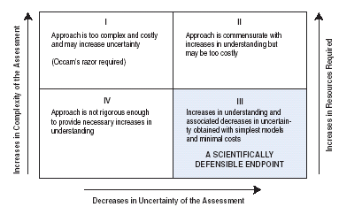 |
| Figure 12. Although attempts to increase understanding of ground-water systems tend to add complexity to a given approach, additional complexity in an approach does not necessarily equate to increases in understanding of the ground-water system or the ability to meet the associated objectives. The challenge in designing an objective scientific approach for a ground-water-vulnerability assessment is to find a reasonable balance among model (or assessment) complexity, resources required, and decreases in uncertainty gained while reaching predetermined science objectives (quadrant III). |
There are many different statistical approaches that can be used to minimize and(or) quantify uncertainty in meeting the science objectives. Three approaches are:
Local-scale process-based determination of the vulnerability of a public ground-water supply to a targeted contaminant.
Management objective: Determine where limited resources can be used most effectively to protect the local ground-water supplies from a specific contaminant 'X'. Also, determine where monitoring waivers and(or) reduced monitoring for contaminant 'X' is most reasonable.
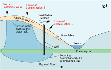
Science objective: Determine contributing areas of targeted wells and identify potential sources of contaminant 'X' in those contributing areas (fig. 13 a and b).
Approach: Develop local-scale deterministic or process-based model or models in conjunction with ancillary data on contaminant sources and monitoring data.
For simplicity, the following assumptions are made (note that these assumptions should eventually be considered when addressing uncertainty in the assessment):
A common approach used is the fixed-radius method (U.S. Environmental Protection Agency, 1997). The fixed-radius method uses a simplified process-based approach to delineate an area (a circular area is used for simplicity but other shapes are possible) around a pumped well. The area is determined by the physically based premise that the time of travel of ground water through the aquifer to the well is a measure of the intrinsic susceptibility of the aquifer. When the limiting time of travel is based on characteristics of targeted contaminants (for example, 2-year time of travel based on presumed pathogen viability: U.S. Environmental Protection Agency, 1997) the assessment is extended from one addressing intrinsic susceptibility to one addressing vulnerability of the well to contamination.
A volume of water (Vw) equivalent to the amount pumped from the well in a given time period (often a 2-year time period is used for pathogens; though it is common to use various time periods and radii for assessments of general contamination) is calculated. This volume is converted to an equivalent cylindrical volume of water Vt and aquifer material using the well as the axis of the cylinder and the screened interval of the well (or thickness of the water bearing zone) as the height of the cylinder (h). The equivalent volume of water and aquifer material is calculated by dividing the pumped volume (Vw) by the porosity of the aquifer material (ne):
Vt = Vw / ne.
Therefore, the radius ( r ) is calculated by:
r = (Vt/(ph))1/2.
This method requires estimated or known values of the average pumping rate over the time period of interest, the thickness of the screened interval, and the porosity of the aquifer material (for this example all are assumed to be known with certainty). This is often the method of choice because where data on pumping rates and well construction are available, the calculation of the radius is limited only by the porosity, which can be obtained from published tables. As shown previously, porosity is the 'effective' porosity in consolidated, fractured rock aquifers. In practice, this method is often used in conjunction with other indicators of vulnerability such as water-quality monitoring and potentiometric-surface mapping as part of a more comprehensive effort, and is presented here for comparative and illustrative purposes.
The obvious major limitations in the radius method that result from a lack of understanding of the ground-water-flow system include: 1) the potential for an inaccurate representation of the contributing area and associated sources of water and contamination for the well, 2) the method generally is not applicable for many contaminants or important processes of contaminant transport, 3) no component of the assessment addresses uncertainty, and 4) the use of a circular or any other geometric shape is subjective. In the absence of consideration of the limitations and uncertainties, the radius method would appear to meet the science and management objectives because using a process-based approach, it results in clearly delineated areas associated with the public water system and therefore, would help to focus decision making where limited resources can be committed to protect the water supply. The radius method is also a relatively inexpensive approach. When including the limitations and uncertainties inherent in this approach however, it would likely fall into quadrant IV of fig. 12 because the decision maker is burdened with the responsibility of determining how scientifically defensible the delineated areas are without the benefit of any further understanding of the ground-water system or assessment of uncertainty.
The following example illustrates a step-by-step procedure to meet the science objectives that can reduce uncertainty in the overall assessment by increasing understanding of the important processes. Figure 13 depicts this procedure for hypothetical wells underlain by flow through an aquifer composed of unconsolidated sediments (note that different considerations can be required if the aquifer is composed of consolidated material). The step-by-step process-based approach that follows is one example that can be undertaken to increase understandings of the flow system and provide a more scientifically defensible product.
A step-by-step process-based approach is as follows:
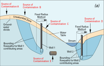 |
Figure 13. A hydrogeologic cross section through an unconfined (water-table) aquifer (a) and a cross section through an unconfined aquifer with an underlying confined aquifer (b). Both hypothetical cross sections contain public-supply wells with potential sources of contamination (A,B,C,D, and E). The commonly used fixed-radius method is applied to Wells 1 and 2 to delineate a subjectively chosen circular area representing the contributing area around each well. With sources of contaminants overlaid on the cross section (indicated by arrows), Well 1 is depicted as vulnerable to the source of contamination at C in the unconfined (a) as well as the confined (b) aquifers. Although this would meet the objectives of the assessment, the conclusions are erroneous because the actual contributing areas do not coincide with the fixed-radius method. In addition, important sources of uncertainty in the fixed-radius method are revealed because the method does not identify potential threats that could be caused by the potential sources of contamination at A, B, D, or E. For example, ‘D’ is clearly within the contributing area of Well 2. Consequently, an objective and accurate depiction of the contributing areas to Wells 1 and 2 is minimally required for a scientifically defensible assessment with reduced uncertainty. |
 |
|
Chemical processes in the unsaturated zone. Deterministic or physically based modeling of contaminant transport through the unsaturated zone based on the governing equations of unsaturated flow is typically not included in ground-water vulnerability assessments (Barbash and Resek, 1996). However, physically based simulation could provide crucial insights into one of the most important components of the transport pathway for many contaminants, and hence ground-water vulnerability, particularly for those contaminants that are impeded or transformed in the soil. |
Quantitative estimates and(or) other indications of uncertainty can be incorporated in process-based and statistical approaches. It is common, and often beneficial, to methodically phase in components of a ground-water-vulnerability assessment over time regardless of the approach. In this way, one can constantly re-evaluate the balance among increases in understandings of the system and resources needed (fig. 12) in meeting the science objectives while accounting for sources of uncertainty. For process-based approaches, the steps provide additional insights on targeted processes; for example, a rudimentary understanding of the potentiometric surface can lead to changes in design of a conceptual model of the flow system that will, in turn, be used to develop a deterministic mathematical model of ground-water flow. Certainly, additional detailed work such as development of solute transport models can incorporate the properties of the contaminant identified above and be designed for the unsaturated and(or) the saturated zones. As with any mathematical model that requires large amounts of data and careful interpretations of results, it is important to avoid undue complexity not commensurate with the objectives of the assessment (quadrant I; fig. 12). On the other hand, too many simplifying assumptions introduced to an assessment in order to avoid complexity can create inaccurate depictions of ground-water vulnerability and a lack of scientific defensibility (quadrant IV; fig. 12).
A step-by-step procedure is often part of a statistical technique because significance of independent variables is determined through hypothesis testing, although many preliminary steps for data gathering and interpretation such as simple summary and descriptive statistics also provide valuable insights and understandings for the next phase of the approach. Probabilistic statistical techniques such as logistic regression can be used, for example, to develop maps of probabilities of detections of targeted contaminants, and their associated statistical significance. It is important to remember, however, that statistical significance does not necessarily imply causal relation.
Regardless of the approach, each step in meeting the science objectives can increase understandings of the ground-water system and assessment accuracy. In this way, success in meeting science objectives is linked to success and reduced uncertainty in meeting the management objectives, and ultimately provides scientifically defensible information for management decisions. In the statistical approach to Hypothetical Example 1, the probability maps will show the decision maker where a contaminant is most likely to be detected based on occurrence data rather than subjective indexes of relative vulnerability. In addition, the statistical approach to Hypothetical Example 1 can provide statistical significance tests about independent variables and model performance that will be crucial in making and defending management decisions about the overall impact of a proposed new standard. In Hypothetical Example 2, the manager will know the strengths and limitations of the vulnerability assessment based on a reasonably complete understanding of the ground-water system. An objective vulnerability assessment supports and helps defend the decisions a manager must make in determining such things as protection areas and monitoring waivers associated with political boundaries, jurisdictions, and competition for fiscal resources.
Next: Conclusions
Back: Overview of methodology
Report