Ground water occurs almost everywhere beneath the land surface. The widespread occurrence of potable ground water and the natural processes that tend to provide barriers to some types of contamination are some of the reasons why ground water is used as a source of water supply by about one-half the population of the United States, including almost all of the population that is served by domestic water-supply systems (Alley and others, 1999).
The ground-water-flow system, as defined in this report, includes effects of geologic deposits, interactions with surface waters, pumping, and other stresses on movement of water controlling advective transport of contaminants. Understanding the ground-water-flow system enables scientists to determine the potentially important factors controlling the intrinsic susceptibility of a ground-water resource. For this report, a ground-water resource is considered to be any aquifer or portion of an aquifer (including a well or wells) regardless of whether it is presently used a source of public water supply. In this way, the actual or potential source water for a public supply and(or) a public-supply well is included in the definition of a ground-water resource, as is any ground water that is not presently used by humans.
The geochemical system, as defined in this report, refers to all physical and chemical factors controlling the source, transport, and fate of natural and anthropogenic contaminants in a ground-water resource. Understanding the natural hydrogeologic and geochemical processes as well as the associated anthropogenic effects on a ground-water resource is required for complete scientific understanding of ground-water vulnerability.
Ground-water vulnerability to contamination was defined by the National Research Council (1993) as "the tendency or likelihood for contaminants to reach a specified position in the ground-water system after introduction at some location above the uppermost aquifer." The National Research Council (1993) refined the definition based on whether the assessment was contaminant specific, defined as "specific vulnerability," or for any contamination in general, "intrinsic vulnerability." The National Research Council definition includes the phrases "a specified position in the ground-water system," and "the uppermost aquifer" in recognition of the complexities of various hydrogeologic settings in relation to used resources and the possibility that the assessment could include an entire aquifer, a portion of an aquifer system, or end at the wellhead. Other relevant definitions are more specific and have separated aquifer characteristics from the broader case of aquifer or water-supply vulnerability to specific contaminants. In this sense, "aquifer sensitivity" or "intrinsic susceptibility" is a measure of the ease with which water enters and moves through an aquifer; it is a characteristic of the aquifer and overlying material and hydrologic conditions, and is independent of the chemical characteristics of the contaminant and its sources. An analogous definition to "aquifer sensitivity" is "intrinsic vulnerability" (Rao and Alley, 1993) defined by the time of travel of water from the point of contaminant entry to the reference location in the ground-water system. Vowinkel and others (1996) defined vulnerability as sensitivity plus intensity, where 'intensity' is a measure of the source of contamination. Clearly, ground-water vulnerability is a function not only of the properties of the ground-water-flow system (intrinsic susceptibility) but also of the proximity of contaminant sources, characteristics of the contaminant, and other factors that could potentially increase loads of specified contaminants to the aquifer and(or) their eventual delivery to a ground-water resource.
|
Intrinsic susceptibility and vulnerability of ground water. The intrinsic susceptibility of a ground-water system depends on the aquifer properties (hydraulic conductivity, porosity, hydraulic gradients) and the associated sources of water and stresses for the system (recharge, interactions with surface water, travel through the unsaturated zone, and well discharge). In this way, intrinsic susceptibility assessments do not target specific natural or anthropogenic sources of contamination but instead consider only the physical factors affecting the flow of water to, and through, the ground-water resource. The vulnerability of a ground-water resource to contamination depends on intrinsic susceptibility as well as the locations and types of sources of naturally occurring and anthropogenic contamination, relative locations of wells, and the fate and transport of the contaminant(s). Water-resource decision makers are often faced with a choice of deciding whether to manage a resource based on knowledge of intrinsic susceptibility or to target more comprehensive and contaminant-specific assessments of vulnerability. |
The vulnerability of a ground-water resource to contamination depends on intrinsic susceptibility as well as the locations and types of sources of naturally occurring and anthropogenic contamination, relative locations of wells, and the fate and transport of the contaminant(s). Water-resource decision makers are often faced with a choice of deciding whether to manage a resource based on knowledge of intrinsic susceptibility or to target more comprehensive and contaminant-specific assessments of vulnerability.
To understand the flow of water to, and through, a ground-water resource one must take into account all physical factors controlling sources of water and water movement. Therefore, it is necessary to understand the principles that govern ground-water movement and, ultimately, the advective transport of potential contaminants.
Under natural conditions, ground water moves in three dimensions along flow paths from areas of recharge to areas of discharge. Recharge occurs everywhere precipitation that falls on the land surface soaks into the ground, moves through the unsaturated zone, and enters the saturated parts of the subsurface. Recharge also can come from water in surface water bodies moving into the ground. Discharge from the saturated subsurface material occurs at springs, streams, lakes, wetlands, bays, the ocean in coastal areas, and as transpiration by plants whose roots extend to near the water table. The three-dimensional body of earth material saturated with moving ground water that extends from areas of recharge to areas of discharge is referred to as a ground-water-flow system (fig. 1).
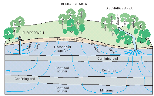 |
| Figure 1. The areal extent and thickness of unconfined and confined aquifers, the length and traveltime of ground-water flow paths, and the thickness of the unsaturated zone vary locally as well as regionally. Figure modified from Heath (1983) and Winter and others (1998). |
The areal extent of ground-water-flow systems varies from a few square miles or less to tens of thousands of square miles. The length of ground-water-flow paths ranges from a few feet to tens, and sometimes hundreds of miles. A deep ground-water-flow system with long flow paths between areas of recharge and discharge may be overlain by, and in hydraulic connection with, several shallow, more local, flow systems (fig. 1).
The age (time since recharge) of ground water varies in different parts of ground-water-flow systems. The age of ground water increases steadily along a particular flow path through the ground-water-flow system from an area of recharge to an area of discharge. In shallow flow systems, ages of ground water in areas of discharge can vary from less than a day to hundreds of years; and ground water in areas of recharge are younger than discharge areas. In deep, regional flow systems with long flow paths (tens of miles), ages of ground water may reach thousands or tens of thousands of years (fig. 1). Shallower and younger ground water tends to be more susceptible to current sources of contamination from land surface. Deeper and older ground water tends to be in contact with naturally occurring contaminants for long periods of time. Understanding the direction and rate of ground-water movement in a ground-water system enables a better understanding and definition of where and why a system is intrinsically susceptible.
Almost any information on the ground-water system of interest will improve the ability to determine the intrinsic susceptibility of the ground-water system to contamination. Of particular use, however, is information that directly relates to the movement of ground water through the system. Aquifer material can be composed of unconsolidated (e.g. sands and gravels) and(or) consolidated geologic material (e.g. granites or limestones; commonly called 'bedrock aquifers'). In either case ground water flows through the void spaces or pores in the aquifer material. Two major factors control ground-water movement in a porous media; factors that define the movement of water within the porous media, and factors that define the movement of water along the boundary of the porous media where water enters or leaves the ground-water system.
Darcy's Law, which describes the flow of ground water within a porous media, defines the volumetric flow of ground water to be directly proportional to the hydraulic gradient and the hydraulic conductivity. The hydraulic conductivity is a property of the porous media and the fluid that represents the ability of the geologic framework to transmit water. The higher the hydraulic conductivity of a porous media, the easier it is for water to flow through it. The hydraulic gradient (i) is the change in head per unit of distance in a given direction.
The average linear velocity is defined as the average velocity of ground water flowing through the pore spaces of a ground-water-flow system. Darcy's Law and considerations of the effective porosity are used to calculate the average linear velocity:
| v = | ( Ki) / ne , eq. 1 |
| where: | |
| v | is the average linear velocity (L/T), |
| K | is the hydraulic conductivity (L/T), |
| Vt | is the total volume
of voids and aquifer material (L3). |
| i |
is the hydraulic gradient (difference
in hydraulic head / distance) (dimensionless), and |
| ne | is the effective porosity (dimensionless). |
The porosity (sometimes called the 'primary porosity') is a function only of the rocks or sediment of the aquifer, which may or may not be available for flow of ground water.
| n = | Vv / Vt , eq. 2 |
| where: | |
| n | is the porosity, |
| Vv | is the volume of voids (L3), |
| Vt | is the total volume of voids
and aquifer material (L3). |
The effective porosity is a function of the interconnectedness of the pore spaces, fractures, or other structures and can be similarly defined:
| ne = | Vvi/Vt , eq. 3 |
| where: | |
| ne | is the effective porosity
of the aquifer (dimensionless), |
| Vvi | is the volume of interconnected voids that are available for fluid transmission(L3), |
| Vt | is the total volume of voids and aquifer material (L3). |
The hydraulic conductivity, effective porosity, and hydraulic gradient are all, therefore, important in determining the volumes and rates of movement of ground water. Hydraulic head is usually measured as water levels in wells. Considerations of the three-dimensional aspects of flow and hydraulic properties require data from wells nested at different depths within an aquifer at a given location. Nested wells are used to measure the amount and direction of ground-water flow in a vertical direction below land surface. The spatial distribution of water levels can be mapped in two-dimensions to depict the potentiometric surface of the aquifer, which in turn shows the direction and rate of flow as limited by the hydraulic conductivity and the two-dimensional representation. Often scientists are able to simplify many ground-water-flow analyses to one or two dominant directions of flow, however, the assumptions necessary for these simplifications must be documented and interpretations must be made within the limitations of those assumptions.
Although the concepts and equations of flow in porous media commonly are used for ground-water flow through unconsolidated aquifers, special considerations are necessary for flow through consolidated aquifers (where the majority of fluids moves through fractures, joints, or other secondary porosity features). For example, the density of fractures in an aquifer or portion of an aquifer is not always an indicator of the best water producing intervals in the rock. Borehole geophysical techniques have been used to show that zones with the highest density of fractures did not necessarily correspond to zones with the highest hydraulic conductivity (Allen Shapiro, U.S. Geological Survey, written comm., 2001). Fractures that produce large volumes of water will depend on the hydraulic conductivity of the fractures, their interconnectivity with other fractures of high hydraulic conductivity, and the proximity to formations or portions of formations with large pore spaces. Fractures in most (but not all) formations account for relatively small porosities (pores constitute only a small volume of the formation) even though they may account for the majority of the volumetric flow rate. Furthermore, hydraulic properties of fractures in consolidated aquifers can differ by many orders of magnitude over the length of boreholes (Shapiro and Hsieh, 1998). It follows that the common practice of assigning a 'representative' hydraulic conductivity or porosity without prior knowledge of the interconnectivity and associated hydraulic conductivity of fractures in a consolidated aquifer will contribute to uncertainties in the assessment.
|
Ground-water flow through fractured rock. Much progress has been made in the development of techniques to characterize flow through fractured rock, however, the techniques tend to be costly and not typically incorporated in most ground-water vulnerability assessments. Recently, however, conceptual similarities found in the distribution of hydraulic properties in fractured-rock aquifers in similar geologic settings suggest transfer value can be provided from one site to the next (Allen Shapiro, U.S. Geological Survey, written comm., 2001). As models and conceptualizations are developed for different hydrogeologic settings in fractured rock aquifers, new understandings and approaches will become available to assess ground-water vulnerability for these complex systems. A thorough appreciation of the limitations in new, as well as conventional approaches that include simplifying assumptions of flow through fractured rock is a crucial component of any application of a ground-water vulnerability assessment. |
Other important factors that define the ground-water-flow system are the sources of water (inputs) to the ground-water resource and the stresses (outputs, including pumping wells) on the system. The external boundaries of the ground-water system, such as streams and recharge areas, affect the paths of water movement and the hydraulic head distribution (Reilly, 2001). The location of wells and rates of pumping also impact where water moves within the ground-water system. Therefore, a ground-water-flow system cannot be accurately understood until spatial and temporal aspects of all flows including inputs and outputs (from natural as well as human influences) are assessed.
The transport of contaminants through ground-water systems is associated with the path taken by the water, the length of time the contaminant takes along the path, and the chemical transformations that occur along the path. An accurate understanding of the potential for advective transport (transport of contaminants due only to the flow of the water) in and through a ground-water resource requires a thorough depiction of the hydrogeologic framework and is an ultimate goal of assessments of intrinsic susceptibility. The path taken by ground water as it transports contaminants through an aquifer is controlled by the ground-water-flow system. The hydraulic conductivity distribution will cause water to flow preferentially in parts of the system with high hydraulic conductivity and to move slower through or around parts of the system with low hydraulic conductivity. The paths taken as ground water moves from sources of contamination to other parts of the system will define the direction and rate of advective transport. Conservative environmental tracers can be used to determine the age of ground water, which is an indication of the rate of advective transport of contaminants. As water flows from the recharge boundary of the ground-water system (which can be a source of surficial contamination), the time it takes for water to reach different parts of the system or to reach wells is an indication of the ability of the ground-water system to advectivally transport contaminants.
|
Contributing areas. The area contributing recharge to a discharging well (fig. 2) is the area at the water table (or top boundary) where water entering the ground-water-flow system will eventually be removed by the well. The contributing area is a function of the interaction of natural sources and sinks with changes in the flow system due to pumping the well. Note that the contributing area, while in proximity to the well, may or may not be contiguous with the well (fig. 2), pumping can reverse flow directions causing natural discharge areas to become sources of recharge (fig. 3), and the contributing area can change as stresses on the resource change. |
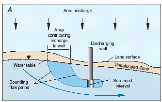 |
Figure 2. Cross-sectional (A) and map (B) views of the area contributing recharge to a discharging well in a simplified hypothetical ground-water system. The contributing area is a function of the interaction of natural sources and sinks with changes in the flow system due to pumping the well. Note that the contributing area, while in proximity to the well, may or may not be contiguous with the well. Figure modified from Franke and others, (1998). |
 |
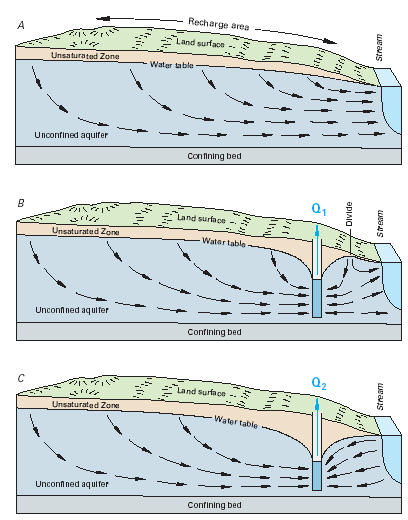 |
| Figure 3. The contributing area to a well can change as stresses on the resource change. Pumping a well can reverse flow directions causing natural discharge areas to become sources of recharge to the well. Figure modified from Heath (1983) and Winter and others (1998). |
Assessments of sources and sinks of water determine where water (and potential contaminants) enters the ground-water-flow system and where it may eventually leave the system. The most common of source of water to ground-water systems is recharge from precipitation. With areal recharge, as illustrated in figure 1, water flows from the water table (where recharge enters the ground-water system for an unconfined aquifer and includes recharge areas associated with outcrops of confined aquifers) and flows through the system to the discharge area (which is a stream in figure 1). The location where recharge enters the system and the rate of recharge are important controls on the quality of water that will ultimately discharge from supply wells.
Surface-water features such as streams and lakes can be either sources of water entering the ground-water system (recharge area) or sinks for water leaving the ground-water system (discharge area). Because surface water also can be a source of recharge (and potential contamination), understanding the interactions of surface water and ground water is part of understanding the entire ground-water-flow system and vital to determining the intrinsic susceptibility of a ground-water resource.
As water (and potential contaminants) migrate from sources at land surface, it first moves through an unsaturated zone before recharging the saturated ground-water system (fig. 1). As water moves through the unsaturated zone, physical and chemical processes occur that can affect the volume and rate of movement of the water (and potential contaminants). Aquifers associated with thick unsaturated zones (deep water tables) tend to have less, and slower moving, recharge than aquifers with thinner unsaturated zones.
The addition of contaminant-specific information to an assessment of intrinsic susceptibility is required in order to develop a complete ground-water-vulnerability assessment. General use of the word "contaminant" in this report can include any natural or anthropogenic chemical or physical property of the ground-water resource in question that is not desirable from a health or other perspective such as interference with water-treatment practices. Potential anthropogenic influences on contaminant sources, fate, and transport must be considered with the natural inherent interconnection of the geochemical system and the ground-water-flow system (Back and others, 1993). For example, a water resource can become more vulnerable to a naturally occurring contaminant if land-use practices affect the ground-water-flow system in such a way that enhances the solubility or mobility of the contaminant beyond the ambient geochemical conditions. Welch and others (2000) provide potential examples of anthropogenic practices that could increase arsenic concentrations in wells.
Contaminant-specific information includes: 1) information on the potential sources of contamination, 2) chemical properties for targeted contaminants or groups of contaminants, and 3) the role of important fate and transport mechanisms as a contaminant moves through the ground-water-flow system.
Understanding the spatial and temporal interactions of land use, the associated potential sources of contamination, and the intrinsic susceptibility of a ground-water resource are key to determining the geochemical system, and ultimately, the vulnerability of ground water to contamination. The potential sources of anthropogenic contamination usually exist along the boundary of the ground-water system with contaminants entering the ground-water system with recharge water. Sources of contamination such as poor well construction and underground point sources such as septic and storage tanks also can become significant issues on a local scale. In addition, the source area for a ground-water supply can change over time as stresses on the resource change (fig. 3-4). Natural sources of contamination depend on aquifer mineralogy and geochemical conditions, and can occur anywhere in an aquifer or water supply on local as well as regional spatial scales.
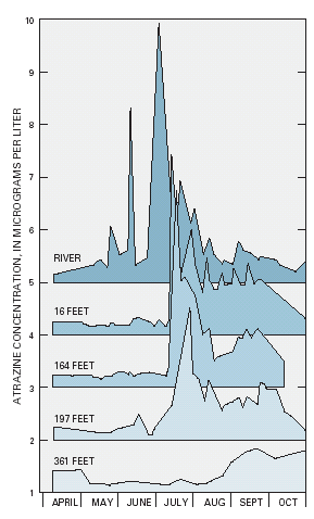 |
Figure 4. Atrazine concentrations in shallow wells tapping an alluvial aquifer and at various distances from a nearby river. The concentrations of the contaminant in the aquifer are clearly related to concentrations in the river. Note the time lag in transport of atrazine contamination through the ground-water-flow system and associated attenuation of peak concentrations due to aquifer properties, chemical reactions, and dilution from surrounding ground water. Interactions with surface water can be a crucial component in the assessment of the intrinsic susceptibility and vulnerability of a ground-water resource. Figure modified from Duncan and others (1991). |
The source of contamination is usually classified in space as either a point source or a non-point source. A point source is a contaminant release at one specific location, whereas a non-point source is released over a widespread area. The source of contamination is also classified in time as either a continuous source or an instantaneous (one time) source. A continuous source is contamination that is released over a long period of time, whereas an instantaneous source is contamination that is released at only one time. The type of contamination source in space and time (that is, point source, non-point source, continuous source, instantaneous source) is important in determining the resulting spatial and temporal distribution of concentrations within a ground-water system. In some cases, the cumulative effects of point sources in proximity with each other can have similar characteristics to one or more non-point sources of contamination.
Contaminants can be transformed by geochemical, radiological, and microbiological processes as they are transported through various environments within the ground-water system. Some chemical transformations can change harmful contaminants into less harmful chemical species, while other processes can produce compounds that are more harmful to ecosystems or human health than the parent compound. The natural decay of some radionuclides can produce daughter products with different transport properties and health effects than the parent product (Focazio and others, 2000). In some cases, transformation products are found in the environment more often than parent compounds (Kolpin, and others, 1997). For example, ground-water remediation programs are increasingly focused on natural attenuation processes controlled by mixing, advection, and biodegradation as these processes serve to decrease concentrations and(or) viability of contaminants (Chapelle and others, 2000). Similarly, some chemical transformations can change relatively immobile compounds into highly mobile compounds, and change parent compounds to transformation products. Knowledge of the path and timing of ground-water movement as well as the chemistry and biology relevant for the contaminant present is important in determining the fate and transport of a contaminant and its associated transformation products. This is important for contaminants that rapidly change to other chemicals in the environment particularly when transformation or daughter products are more persistent than the parent compound. In addition, the vulnerability of a ground-water supply to many contaminants is dependent on the solubility and subsequent mobility of the contaminant as influenced by the specific mineralogy and associated geochemical conditions within the aquifer and pumped well. For example, naturally occurring arsenic can be tightly bound to aquifer materials in certain geochemical conditions but can be subsequently released to the pore waters of the aquifer if those conditions are changed, Welch and others, (2000). The chemical properties of a contaminant are important in the unsaturated zone as well as the aquifer itself. For example, some (hydrophobic) compounds strongly attach to soils in the unsaturated zone (as well as the saturated zone) before reaching the water table, and these compounds are attached until released by geochemical or other changes such as when the binding capacity of the soil is exceeded.
Diffusion and dispersion are among the important transport mechanisms that tend to spread contaminants as they move through the ground-water system. This spreading tends to lower contaminant concentrations in some parts of the system and increase concentrations in other parts beyond which would be realized by advection alone. Diffusion is the process by which both ionic and molecular species dissolved in water move from areas of higher concentration to areas of lower concentration. Dispersion is the process whereby solutes are mixed during advective transport due to velocity variations caused by flow variations within the pores and by heterogeneities in the hydraulic conductivity distribution (fig. 5). Dispersion usually causes more mixing than simple molecular diffusion.
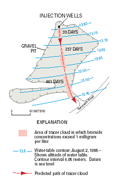 |
Figure 5. An instantaneous point source tends to spread out as the contaminant moves through the ground-water system. This is shown in the results of a tracer test conducted at Cape Cod, Massachusetts. A conservative tracer (one which does not decrease in concentration due to chemical reactions along a transport pathway) was introduced into the aquifer by three injection wells. As the plume of tracer moved down gradient with the ground water, the plume spread out due to dispersion. The dispersion caused the maximum concentration of bromide in the plume to decrease from 429 mg/L (milligrams per liter) at 33 days to 65.2 mg/L at 237 days to 39.0 mg/L at 401 days since injection. However, the area of the tracer in which bromide concentrations exceeded 1 mg/L tended to expand. If there were no dispersion, the injected tracer cloud would not have changed shape and concentration as it moved with the ground water. Thus, the effect of dispersion on the concentration of contaminants moving in a ground-water system can be important in determining the vulnerability of the aquifer to contamination. As the contaminant disperses, the maximum concentrations decrease and areas of the ground-water system that are not directly in the flow path can become contaminated as the plume spreads out. Figure modified from LeBlanc and others (1991). |
Next: Overview of Methodology
Back: Introduction
Report