The mining geology program began in 1879 with comprehensive studies of the geology and technology of three great mining districts--Leadville in Colorado, and the Comstock and Eureka in Nevada--and the collection of mineral statistics in the Western States. In addition, through a cooperative arrangement with the Tenth Census, mineral statistics were collected in the Eastern States, iron resources in all parts of the country were systematically studied in the field and in the laboratory by a variety of techniques, including microscopic analysis, chemical analysis, and magnetic observations, and an effort was made to trace the continuation of the copper-bearing rocks of Michigan and Wisconsin through northeast Minnesota to the Canadian boundary. The investigations in general geology included the unfinished studies of the earlier surveys in the Colorado Plateau region, on the Quaternary history of valleys in Utah, and on the geology of the Rocky Mountain region north of New Mexico and west of the 94th meridian.
In his first annual report, King promised 12 volumes on "practical and general geology and paleontology."11 Some were published as part of the Tenth Census reports, including the mineral statistics that provided the first comprehensive study of the Nation's mineral resources, others as monographs of the U. S. Geological Survey.
King resigned as Director in March 1881. He had not planned to stay beyond the time necessary to organize the work, and when James Garfield became President King realized that he would no longer have the support of his good friend, Secretary of the Interior Carl Schurz, whose views on political reform, including a merit-based civil service system, he shared. Despite his short tenure, King had such a profound influence on the organization and mode of operation of the Survey that decades later his imprint was still clearly evident and can be recognized even to this day.
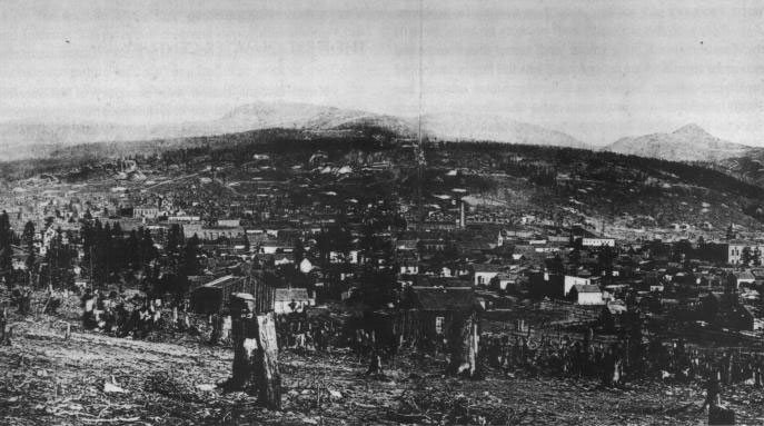
Figure 10. Leadville, Colorado, mining district, subject of an early mining-geology study, 1879.
King's choice to succeed him was John Wesley Powell, who was almost King's antithesis in background, education, and experience. Both men had wide-ranging scientific interests but King's centered on mathematics and geophysics, and Powell's tended toward natural history and anthropology. In geology, which Powell considered part of geography, he was primarily concerned with landforms and land use.King and Powell also differed greatly in their philosophies of administration, which King apparently did not realize when he resigned. King had given the work of the Geological Survey a mission orientation, planned the goals, and selected the staff, but given them freedom to choose their methods of work in order to achieve the goals. Powell allowed the staff to choose not only their methods of work but the subjects they would investigate as well. That alone meant an immediate change in the Geological Survey's program. In addition, because Powell looked on geology and topography as independent although closely related parts of the greater field of geography, he made the topographic work of the Geological Survey independent of geologic studies as soon as he became Director. Powell also retained direction of the Bureau of Ethnology and simply merged the work of the two organizations.
In 1882, Powell obtained authorization from Congress "to continue the preparation of a geologic map of the United States,"12 which implicitly extended the work of the Survey to the Eastern States without explicitly clarifying the public lands-national domain question. Powell then redirected all topographic work toward preparation of the geologic map and began topographic mapping to provide a base for the geologic map in Eastern as well as Western States. Topographic mapping became the largest part of the Geological Survey program. Paleontologic and stratigraphic studies to support the geologic mapping program were also begun throughout the country. Mining geology, however, was restricted to the Western States--Powell insisted that no authorization had been obtained for mining geology in the Eastern States--and had insufficient funds for field work.
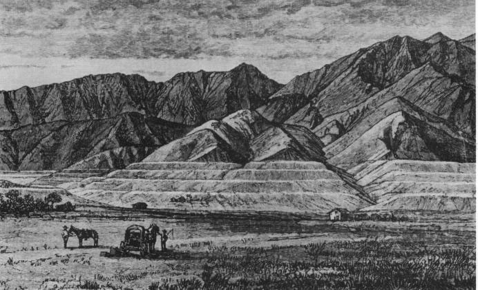
Figure 11. Shorelines of ancient Lake Bonneville, subject of an early general-geology study, 1879.
During Powell's first 3 years as Director, the Survey prospered, and its appropriations grew steadily, amounting to $386,000 for the fiscal year beginning July 1, 1884. By that time, King's simple organization of the Survey into Mining Geology and General Geology had been transformed. General geology, initially described by Powell as structural geology and paleontology, became five divisions of geology and five of paleontology. The chemical laboratory, mining statistics, preparation of illustrations, and the library were "accessory"13 divisions. Without benefit of formal organization, the Geological Survey was also investigating the irrigation of the arid lands, the relief from floods that would be afforded the lower valley of the Mississippi by utilizing waters from the Rocky Mountains for irrigation, and the geographic distribution of the great forest areas.The appropriations act for the fiscal year beginning July 1, 1884, however, also included provisions for two Congressional investigations: one by the Joint Committee on Public Printing aimed at reducing the cost of public printing, especially the cost of scientific publications, which had become a matter of some concern; the other an investigation of the organizations of the Signal Service, Geological Survey, Coast and Geodetic Survey, and the Hydrographic Office of the Navy, to secure greater efficiency and economy of administration of the public service among them. The latter investigation was ostensibly a general one but was actually a combination of two investigations, one of the Signal Service and the other an attempt to save the Coast and Geodetic Survey from the encroachment on its functions by the Geological Survey, with its newly extended topographic mapping program, and the Hydrographic Office. Common to both was the old argument of civilian versus military control of science.
The National Academy of Sciences, again called on for advice, recommended that all the scientific work of the Government be concentrated in four bureaus, organized on the basis of scientific discipline, and that the four should preferably form a separate Department of Science or at least be in one executive department. Others expressed the opinion that scientific work should be conducted in and directed by the department that needed scientific assistance, and still others held that the scientific work of the Federal Government should be severely limited in scope.
The lameduck Congress that met in December 1884 had to face serious economic problems and a mandatory close on March 4, 1885. The Joint Committee on Public Printing decided to leave to the new Congress the task of drafting a bill to reduce the cost of public printing. The Commission on the Organization of the Scientific Work of the Government held hearings, then obtained authorization to continue the hearings when the new Congress convened, and in 1886, presented a divided report. The majority recommended no changes in the organization of the existing bureaus and, with respect to the Survey, noted that on the basis of the current annual appropriation it would require 30 years to complete the geological survey of the whole country but thought the rapidity with which the work was done could be left to Congress to determine through the amount of the appropriation. The minority called for restriction of paleontology to the collection, classification, and proper care of fossils, and for prohibition of general discussions of geologic theories and of the publication of anything except an annual report of operations. In the next session of Congress, the Geological Survey was directed henceforth to present itemized estimates in requesting funds so Congress could control expenditures, and the amount the Public Printer was authorized to spend on Geological Survey publications was drastically reduced.
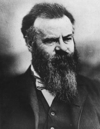
Figure 12. John Wesley Powell, Director of the U.S. Geological Survey, 1881-1894.
More trouble for the Geological Survey was already developing on another front. A few months after becoming Director, Powell had submitted a report to the second session of the International Congress of Geologists in which he attempted to establish rules "adopted"14 in the Geological Survey as the American norm for stratigraphic nomenclature and cartographic representation. Only one American geologist attended the Congress, which voted to adopt other terms largely of European derivation. Following the 1885 Congress, however, the American Committee met and voted to adopt the decisions of the International Congress and to recommend their acceptance by American geologists. American opinion on stratigraphic nomenclature was divided, as became clear in meetings held in 1887, but the American Committee sent its reports to the 1888 International Congress without prior distribution in the United States, arousing considerable protest. In August 1888, American geologists voted to form an American geological society and the first meeting of the Geological Society of America was held on December 27, 1888. Three weeks before the Geological Society held its initial meeting, Powell convened a conference of Federal geologists on "geologic taxonomy and nomenclature" with the claim that "the range of conception concerning geologic principles and methods among the Federal geologists has become an epitome of the geologic opinion of the earth."15Powell was temporarily diverted from the geologic map and stratigraphic nomenclature by a change in climate in 1886. During the 1870's and early 1880's, great numbers of people had settled on the Great Plains, and would-be farmers came into competition with cattlemen for water and land. The drought of 1886 and the severe winter that followed compounded the difficulties. In October 1888, Congress authorized a survey to investigate the extent to which the arid region of the United States could be redeemed by irrigation, to segregate the irrigable lands, and to select sites for reservoirs and other hydraulic works for the dual purpose of storage and utilization of water for irrigation and prevention of floods and overflows. To prevent speculation, Congress then stipulated that all lands that might be irrigated by the reservoirs and canals to be located by the surveys be withdrawn from entry.
In his arid lands report of 1878, Powell had defined the arid region as the region where rainfall was less than 20 inches a year, and so most of the area west of the 100th meridian was in his arid region. Between the arid region of the West and the humid region of the East was a region, which Powell called the subhumid region, where rainfall was 20 to 28 inches a year. Most of the farmers who had been hurt by the change in the weather were in the subhumid region or the eastern edge of the arid region.
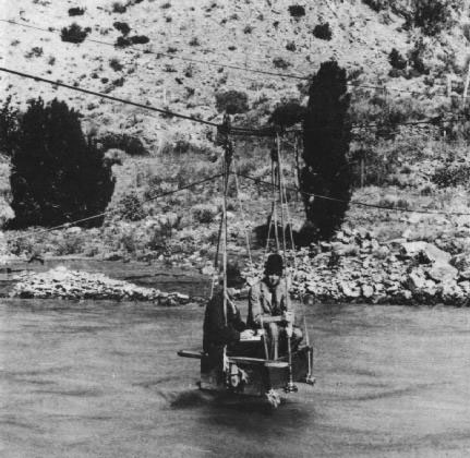
Figure 13. An early method of stream gaging, 1890.
Given the opportunity he had so long awaited to attack the problem of the arid lands, Powell planned first topographic surveys to plot catchment basins, then a hydrographic survey to measure streamflow, and finally an engineering survey to determine the feasibility of construction. The topographic mapping was begun in October 1888, immediately after passage of the Appropriation Act, as an expansion of the regular topographic mapping program in Colorado and areas to the west. The stream-gaging and engineering surveys had to wait upon the training of hydrographers and the recruitment of engineering personnel and did not get underway until 1889. Men experienced in stream-gaging methods and instruments were scarce, so 14 young men were chosen and placed in an instruction camp, under the direction of F.H. Newell, a 26-year-old engineer who had graduated from the Massachusetts Institute of Technology in 1885.
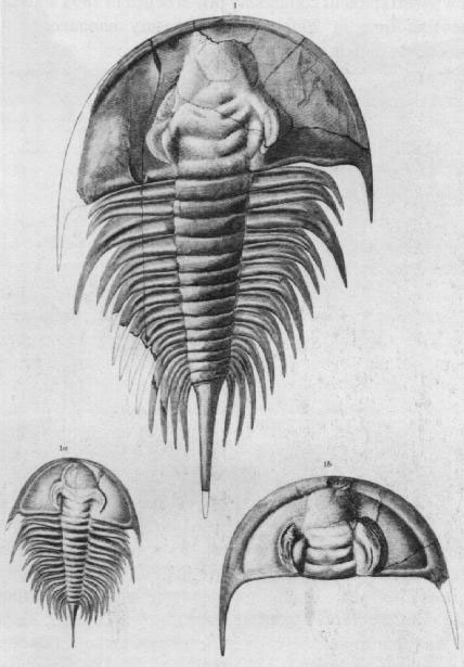
Figure 14. Olenellus, a genus of trilobites that C.D. Walcott found marked the lowest zone of the Cambrian, 1890.
The Irrigation Survey was discontinued in 1890. Congress was impatient for results, but Powell insisted that all the facts had to be determined before any recommendations could be made. In May 1890, the Acting Attorney General ruled that all irrigable lands had been withdrawn from entry on October 2, 1888, and as no one knew which lands were irrigable until the Survey certified them, all claims filed after that date had to be invalidated. The public domain was in fact closed to entry, a situation which advocates of western development did not want at any cost. To complicate the situation, six new States had been admitted in 1889 and 1890, some wholly, some partly in the arid region, and their dowry lands, the public lands ceded by Congress to new States from which they would derive their taxes, were also withheld. In the summer of 1890, Congress repealed the provision for withdrawal of lands except those selected as reservoir sites and provided no further funds for the Irrigation Survey.The demise of the Irrigation Survey was the first serious setback; another followed 2 years later. The year in which the Irrigation Survey was discontinued was one of almost universal national discontent in the United States. Farmer and labor organizations began to join together with other protest groups to achieve their common objectives. The monetary situation was precarious. Production of gold had been declining for many years while the production of silver had steadily increased and its market price as steadily declined. In 1890, the silver and inflationist forces in the Senate, reinforced by the Senators from the recently admitted States of North and South Dakota, Montana, Washington, Idaho, and Wyoming, succeeded in passing a bill for free and unlimited coinage of silver. The House blocked that bill, but a compromise bill passed in July 1890 required the Treasury to purchase 4,500,000 ounces of silver each month (the estimated total U.S. production) at the prevailing market price and to issue in payment legal-tender Treasury notes redeemable in gold or silver at the option of the Treasury. The effect was an increase in the circulation of redeemable paper currency and a weakening of the Federal gold reserve, creating a fear that the silver inflation might take the country off the gold standard. A new downward spiral of commodity prices began in 1891, and for the first time in 20 years the Treasury announced an impending deficit.
At this critical point in its history, the Geological Survey was out of favor with Congress, with many American geologists, who felt that it had too often acted unilaterally, and with some elements of the mining industry, who felt that economic geology was being neglected. In a mood for economy, Congress in 1892 slashed appropriations for scientific agencies, especially those items which seemed to have little immediate practical purpose. The Geological Survey's appropriations for geologic surveys, paleontology, and chemistry and physics were drastically reduced, and several statutory positions were eliminated. Only the appropriation for the report on mineral resources went unscathed, although the appropriation for topographic surveys was cut only a little. The Senate then appointed a Select Committee to "investigate the operations of the United States Geological Survey, the efficiency and utility of such a survey, together with the progress made and economy observed in this work."16
The congressional action was clearly aimed at Powell and his administration of the Geological Survey, and the reasons for it were equally clear. The principal reason was that Survey science was not serving the great economic interests of the country although the all-encompassing nature of the Survey work or resentment of Powell's ideas of land reform and the closing of the public domain during the Irrigation Survey, to which some historians have attributed the action, may have played a part. In particular, Senators from the mining States in the West, which were also States in the arid region, wanted economic geology restored to the preeminent position it had had under King, and members of Congress in the South and East wanted economic geology investigations in their region. A few powerful Senators in fact wanted to force Powell's resignation and to restore King to the directorship.
Powell continued to occupy the position of Director until June 30, 1894, but his control of the Survey's geologic work came to an end in August 1892. Charles D. Walcott gradually took charge, first on an emergency basis when Powell was absent from the office for several months, then with administrative responsibilities delegated by Powell. On July 1, 1893, the Secretary of the Interior appointed Walcott Geologist-in-Charge of Geology and Paleontology. In the spring of 1894, Powell told the House Committee on Agriculture, then considering legislation to transfer the Geological Survey from the Department of the Interior to the Department of Agriculture, that although the Geological Survey when it was organized was supposed to be concerned principally with mines and mining, the bulk of its operations were now concerned with agriculture. The Secretary of the Interior requested a cut in Powell's salary, a device used by the administration to embarrass officials and force their resignation, and Powell submitted his resignation in May 1894. The Secretary of the Interior promptly recommended to President Grover Cleveland the appointment of Walcott as the third Director of the U.S. Geological Survey.
Walcott was not an obvious choice for the position in view of the congressional desire for more emphasis on economic geology. He was a man of unusual administrative and scientific ability, but, although he had already established an international reputation in what he chose to call paleontologic geology, as late as 1890 he was one of the lower-paid paleontologists and in 1892 had been on the verge of leaving the Survey to become a professor at the University of Chicago. Walcott, however, had been one of King's early appointees, as an assistant geologist at $600 a year, and had been part of the group that worked with King in New York after King's resignation as Director. Walcott understood the difficulties the Geological Survey faced and the steps that had to be taken. In fact, in the request for funds that was sent to Congress in December 1892, the purpose for which the geologic surveys were to be made was changed from "preparation of the geologic map"17 to "locating and representing by maps, sections, and reports,"18 the various mineral resources known or believed to exist in 17 different areas, including those in the Eastern States.
Walcott's appointment was greeted with cautious approval by geologists but more or less ignored by the mining fraternity, although King assured them of his administrative ability. Walcott revived the mission orientation of the Geological Survey as outlined by King in 1879 but broadened the mission beyond that envisioned by King. The Survey would aid not just the mineral industry but all industries--in fact any practical objective that could be aided by a knowledge of geology. It would not, however, be limited to practical geology but would undertake basic research whenever research was necessary in the solution of a geologic problem.
Walcott abolished all organizational units within the Geologic Branch and assumed direct control of the work. Mining geology studies were resumed and extended into the Eastern States, and in view of the gold crisis, an intensive study of gold deposits, including exploration for new sources, was begun. The deposits at Cripple Creek, Colorado, a little-understood telluride ore, were studied, as were those at Mercur, Utah, which had become usable through development of the cyanidation process. Studies of gold deposits in Alaska began in 1895. By 1900, the value of gold produced annually in the United States was more than twice what it had been in 1890, and the United States adopted the gold standard as its monetary base. The mining-district studies were not restricted to gold but were also undertaken in the iron districts of Michigan and Minnesota and the copper districts of Montana, Utah, and Arizona. Nor were they held to practical matters only. By 1900, the ideas on the classification and genesis of ores, which King had hoped would come from the mining geology program, were matters of intense discussion; papers on these topics at the meeting of the American Institute of Mining Engineers in 1901 became landmarks in the history of geology.
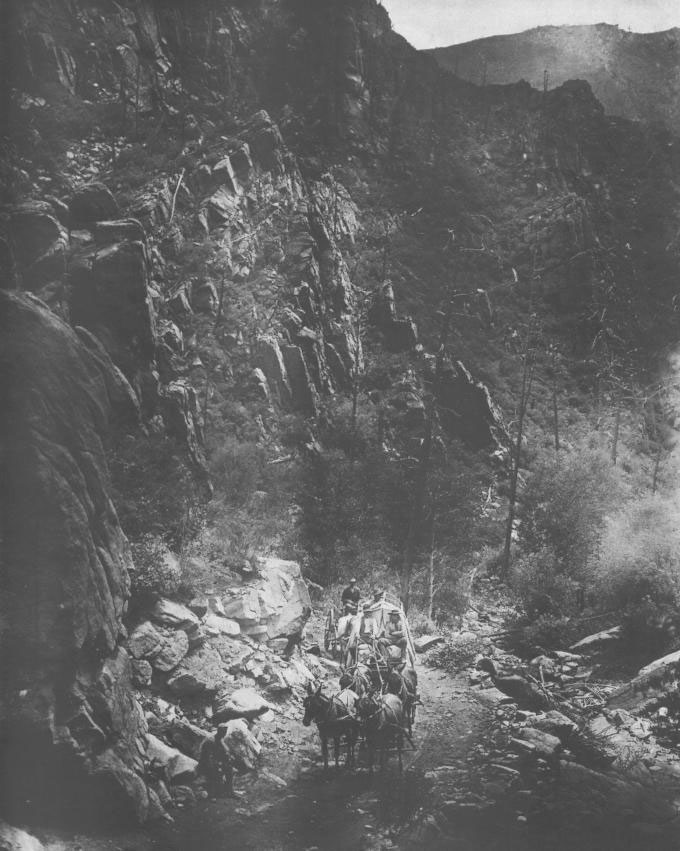
Figure 15. A geological party on its way to map the Cripple Creek mining district, Colorado, 1893.
Basic science was an integral part of the Geologic Branch program. Fundamental studies were made in the genesis of ore deposits, in paleontology and stratigraphy, in glacial geology, and in petrography. The geologic time scale was revised, new definitions for rock classes were developed, and the first geologic folios were published.
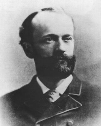
Figure 16. Charles Doolittle Walcott, Director of the U.S. Geological Survey, 1894-1907.
Geology was also extended to include the study of water. In 1894, a small appropriation was obtained for the purpose of "gauging the streams and determining the water supply of the United States."19 Streamflow measurements begun during the Irrigation Survey had been continued in a modest way as part of the topographic mapping program after the Irrigation Survey was discontinued in 1890. With the new appropriation, work was expanded. In 1895, the work was transferred to the Geologic Branch, and studies of underground water and water utilization were gradually added to the stream gaging. Appropriations were increased regularly, and in 1896 a new series of publications was inaugurated to make available the ever-increasing volume of information. The Irrigation Congress that met in Phoenix in December 1896 reversed the opinions of earlier congresses with regard to the Geological Survey's role in public-land management by recommending establishment of a Public Lands Commission, including the Director of the Geological Survey as a member, to be responsible for preparing a topographic map, determining the water supply, ascertaining the character and value of the timber, and making regulations for the occupation and utilization of the public lands.
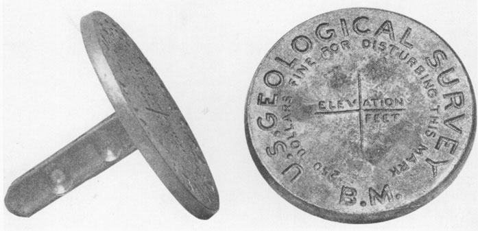
Figure 17. Bench marks, showing elevations above sea level, greatly enhanced the value of topographic maps, 1896.
The development of the topographic work followed a similar pattern. Before Walcott became Director, the work of the Topographic Branch of the Survey had been criticized by many who considered the extensive program inappropriate for a geological survey and more properly part of another organization, but at the beginning of his directorate Walcott simply announced that topographic map quality would be improved. Within a few months, the topographic corps was placed under Civil Service, thus eliminating some of the difficulties of the Powell era when many with inadequate or no training, including congressional relatives, had been employed. A practical demonstration was made of the advantages of combining topographic surveys and the subdivisional surveys of the General Land Office in Indian Territory. The value of topographic maps for practical purposes was greatly increased by the placement of permanent bench marks showing the exact location and elevation of fixed points.
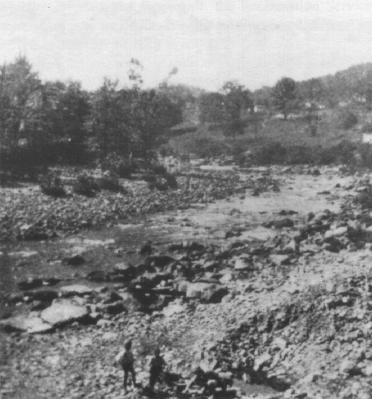
Figure 18. Pollution of the Potomac River by industrial wastes such as sawdust and tannery products was recognized by Survey hydrographers, 1897.
By 1897, Walcott had regained the confidence of Congress. The Forest Management Act that year placed management of the forest reserves in the Department of the Interior and required that surveys of the "public lands that have been or may be designated forest reserves"20 be made under the supervision of the Director of the Geological Survey. Survey topographers within the next 3 years mapped more than 32,000 square miles in and adjacent to the reserves, even though most were in wilderness areas. At the same time, a program of topographic mapping on the larger scales needed for more urbanized areas was steadily growing in cooperation with the Eastern States.In the late 1890's, geologic work was extended into new fields and went beyond the national domain. In 1897, a Survey geologist and a hydrographer were detailed to the Nicaraguan Canal Commission to study the proposed canal route between the Atlantic and Pacific Oceans. The Commission made extensive use of their findings, marking perhaps the first time on this continent that geological evidence provided support for a great engineering project. After the Spanish-American War in 1898, Survey geologists were sent to investigate the mineral resources of Cuba and the Philippine Islands.
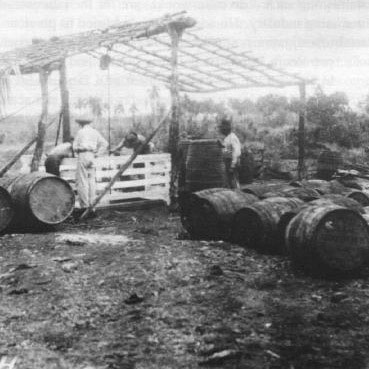
Figure 19. A geologist examining an asphalt well in Cuba after the Spanish-American War, 1900.
In 1897, a Senate resolution called for a three-man commission, including the Director of the Geological Survey, "to determine the best method of ascertaining all the facts of general importance relating to mines and mining within the United States, whether by a mining bureau, a Secretary of Mines and Mining, a Commissioner of Mines, or a commission."21 In December 1898, a Senate resolution called for a Division of Mines and Mining in the Geological Survey to gather statistics on mineral resources and mineral production and to make investigations related to mines and mining. Walcott agreed that the mining interests should be represented in the organization of the Government and that establishing such a division would care for the interests of the mining industry. He added that, in addition to precious metal investigations, studies should be undertaken of coal, coke, petroleum, asphalts, building stones, and clays.
In 1900, a bill for establishment of a Department of Mines with the Survey as a nucleus was filed but not acted on. However, when Congress appropriated for the Survey 110 percent of the amount it had requested, the Geologic Branch was reorganized, and a Division of Mining and Mineral Resources was established.
The reorganization of the Geologic Branch on July 1, 1900, was an experiment designed to separate scientific and administrative control. Seven divisions were established, covering specified subject areas, each in charge of a specialist who would prepare plans of work, establish priorities, recommend geologists to undertake particular projects, and review manuscripts. Party chiefs would plan the conduct of the work. The Director would approve plans and make allotments. In essence, it was King's plan of 1879 adapted to a larger organization.
In his presidential address to the Geological Society of America in December 1900, Walcott foresaw that the "standards of the future will be progressively higher and higher, and the scope of routine investigations will become broader. As geologic science progresses, and as new uses are discovered for mineral resources, it will become necessary to increase the number of classes of facts to be covered by areal surveys. * * * Every investigation undertaken to solve some geologic problem, whether it prove successful or not, is sure to develop other problems, and the geologic Alexander will never lack worlds to conquer."22
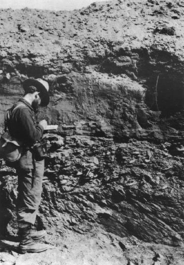
Figure 20. A Survey geologist examining gold-bearing gravels near Nome, Alaska, 1901.
At the time, Federal science was clearly enjoying a new but somewhat hazardous status. While becoming more involved in the economic life of the Nation, it was at the same time tending more and more toward the practical, so Washington scientists were seeking private funds to support basic research. In May 1901, the Board of Trustees of the Washington Memorial Association, of which Walcott was president, was incorporated "to promote science and literature; to provide opportunities and facilities for higher learning, and to facilitate the utilization of the scientific and other resources of the government for purposes of research and higher education,"23 and a plan for a nongovernmental institution to promote the study of science and liberal arts in Washington was developed. The trustees conferred with Andrew Carnegie, who agreed to endow the Carnegie Institution of Washington for the purpose of "extending human knowledge by original investigations and research."24 The trustees of the new institution, of which Walcott was Secretary, defined the limits of research as the limits of the knowable, and concluded that the function of the institution should be the substitution of organized for unorganized effort whenever it promised the best results, and the prevention of needless duplication of work, pointing out that no investigator, working alone, could approach the largest problems in the broadest way thoroughly and systematically.The accession of Theodore Roosevelt to the Presidency in September 1901, after the assassination of President William McKinley, very quickly had an effect on the Survey program. By inclination and training, Roosevelt was in full sympathy with the movement for scientific management of the Nation's resources, and in his first State of the Union message, in December 1901, outlined a national forest and water policy. The long effort to promote reclamation of the arid lands, with which both Walcott and F.H. Newell were associated, culminated in passage of the Newlands Act in June 1902 and the establishment of the Reclamation Service. At the same time, the appropriation for the Geological Survey's water-resources investigations was increased and the total appropriation for the Geological Survey for the first time was more than $1 million. At the direction of President Roosevelt, the Reclamation Service became an adjunct of the Geological Survey, and Walcott served as director of both agencies.
The organization of the Geologic Branch was again altered when Walcott assumed additional duties as Director of the Reclamation Service and Secretary of the Carnegie Institution of Washington in 1902. Administrative control of five divisions was transferred from the Director to the Geologist-in-charge of Geology and Paleontology, and those five divisions became sections in the Division of Geology and Paleontology. The Division of Physical and Chemical Research and the Division of Mining and Mineral Resources remained under the administrative control of the Director. The Hydrographic Division was separated from the Geologic Branch and became the Hydrographic Branch. In 1903, the Division of Alaskan Mineral Resources, in effect an Alaskan geological survey because it included topographic mapping, was established in the Geologic Branch.
Federal science had then become so involved in the economic life of the Nation that inevitably it also became caught up in the making of national policy. The Geological Survey through its Director had had a hand in the passage of the Forest Management Act in 1897 and the establishment of the Reclamation Service in 1902. Shortly thereafter the Geological Survey also became involved in the regulation of industry. When the coal resources of the Nation became a matter of public interest because of the hardships endured during the prolonged anthracite coal strike in 1902, President Roosevelt appointed a commission, including among its members the Survey's coal statistician, to arbitrate the dispute. The commission in its report was critical of the rivalry between railroads, which owned or controlled more than 96 percent of the anthracite deposits, of wasteful methods of mining, and of mining safety practices, and the Commissioner of Corporations in the newly established Department of Commerce and Labor promptly began an investigation of some of these problems.
Early in 1903, President Roosevelt also appointed the Director of the Geological Survey chairman of a committee to investigate the scientific work of the Government to increase its usefulness, efficiency, and economy. The committee concluded that, in general, the work of scientific research on the part of the Government should be limited primarily to utilitarian purposes and that research in pure science on broad and general grounds should be within the scope of private institutions. The committee favored organization of research around a problem rather than a discipline, and recommended the transfer of several bureaus, including the Geological Survey, to the Department of Agriculture, which already included one-third of all Federal scientific bureaus, received three-fifths of all appropriations for scientific work, and employed two-thirds of all Federal scientists. No action was taken on these recommendations but at the time President Roosevelt was much involved in foreign affairs, including negotiations for the isthmian canal and Alaskan boundary problems.
In 1904, the U.S. Geological Survey celebrated the 25th anniversary of its establishment. It had grown from an organization of 38 employees at the end of its first year to one with 491 employees (and another 187 in the adjunct Reclamation Service) in 1904. Its first appropriation had been $106,000; the appropriation for the fiscal year that ended on June 30, 1904, was $1.4 million. It had become the leading geologic institution in the United States in the view of "American Men of Science," and many of the 100 geologists whose work was considered most significant by their peers, including the first five ranked numerically, were associated with the Survey. To mark the anniversary, a bulletin describing the Survey and its operations during the 25 years was published. Among the achievements noted were preparation of topographic maps of 929,850 square miles of the United States (26 percent of the country including Alaska) published as 1,327 atlas sheets; geologic mapping of 171,000 square miles and publication of 106 geologic folios; experimental and theoretical investigations of the physical characteristics of rocks in various processes of formation, of volcanic and geyser action, and of rock composition and structure; paleontologic and stratigraphic studies; streamflow measurements and their analysis, which, among other things, had stimulated the development of water power, especially in the Southern States; and studies of irrigable lands and detailed examination and classification of 110,000 square miles of the forest reserves.
Of all the work of the Geological Survey, the bulletin concluded, its immediate value to the people was best shown by the aid extended in developing the mineral resources and in forwarding important engineering projects in which the people, as well as Federal and State Governments, were interested. Singled out for special mention were the investigations of the mining geology of Leadville, of the Lake Superior iron ores, and of the Appalachian coal field.
The mining geology program had, in fact, been a major factor in the development of economic geology as a distinct field in geology, composed of both theoretical and practical aspects. The 25th anniversary of the Survey coincided with the beginning of a new journal Economic Geology, and with a call from the American Mining Congress for establishment of a Department of Mines and a counter statement from the Engineering and Mining Journal that a bureau of mining should be established under the Director of the Geological Survey because "in no other country--we say it advisedly--has economic geology been applied to the development of industry with such beneficent results as in the United States, and no geological survey has contributed so much to the practical application of the science of geology in mining operations as has the organization in whose behalf we bespeak the earnest interest of our readers."25 What the Survey needed, the Journal said, was greater scope for economic geology and "freedom from the encroachments of the wood and water departments."26

![]() U.S. Department of the Interior |
U.S. Geological Survey
U.S. Department of the Interior |
U.S. Geological Survey
URL: http://pubsdata.usgs.gov/pubs/circ/c1050/first.htm
Page Contact Information: GS Pubs Web Contact
Page Last Modified: Tuesday, 01-Oct-2019 08:22:50 EDT