Five-High storm
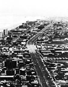
The dashed line on this 1978 photograph marks the approximate limit of the storm surge during the Five-High storm of March 1962. Most of the large buildings within the storm-surge zone were constructed during the 1970's; capital expenditures for these buildings and the large number of mobile home parks that are also within the surge zone were more than $100 million. Their value today is several billion dollars. (From Dolan and others, 1980.)
| Maintained by J.M. Watson | https://pubs.usgs.gov/circ/c1075/fivehigh.html | Last updated 9.11.97 |