Chicago, Illinois
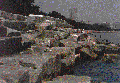
Parts of Chicago's protective seawall are 80 years old and badly deteriorated.Chicago's extensive waterfront along Lake Michigan includes many engineering structures built 50 to 80 years ago to protect the city from storm waves and flooding. A period of high lake levels in the mid-1980's exacerbated the deterioration of many of these aging seawalls, revetments, and other structures. The U.S. Geological Survey (USGS), in cooperation with the Illinois State Geological Survey, used sidescan sonar instruments to determine the causes and extent of the deterioration. This knowledge contributed potential savings of tens of millions of dollars to the structural repair of Chicago's waterfront by distinguishing areas that were still structurally sound from those needing repairs. Other USGS studies in progress provide data on the specific erosional processes at work, vital knowledge for those attempting to mitigate the damages. Water levels have dropped slightly since the record highs of a few years ago, but continuing studies have shown that those highs are part of the natural cycles of lake-level fluctuations in the Great Lakes.
| Maintained by J.M. Watson | https://pubs.usgs.gov/circ/c1075/rocks.html | Last updated 9.11.97 |