
Highlight 9--Areas of Florida That Could Be Inundated
by Sea-Level Rise
Cooperative mapping by the Florida Bureau of Geology and the GD, through the Quaternary Geologic Atlas of the United States effort, identified those parts of coastal Florida dating to the last interglacial period; these areas are underlain by rocks known as the Anastasia Formation, the Miami Oolite, the Key Largo Limestone, and the upper part of the Fort Thompson Formation. This interglacial period is the last time that global climate was significantly warmer than present, and sea level was 7-8 meters (about 23-26 feet) higher than it is today. Figure 9 depicts where the coastline of Florida was during this past warm climate and where it could be in the future should global warming reach the same levels as in the past. Wildlife habitats such as the Everglades and critical facilities such as the Kennedy Space Center on Cape Canaveral would be under water, and the lives and properties of more than 7 million Florida residents would be affected.
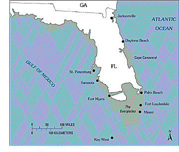
Figure 9. Shoreline of Florida during the last geologic period of significantly warmer climate. Areas shown in green might be under water if global warming should reach the same levels as in the past. From Scott and others (1986a,b) and Copeland and others (1988).
<----- Back to Goal 4
This page is <https://pubs.usgs.gov/circular/c1172/h9.html>
Maintained by L. McElroy
Last updated 04.08.98