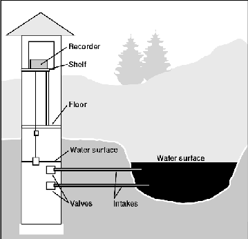
Figure 10. Schematic of a stilling well and shelter.
Standard methods of data collection are used as described by Rantz and others ( 1982 ) and in the publication series Techniques of Water-Resources Investigations of the U.S. Geological Survey. Those methods are briefly described in the following sections.
Figure 10. Schematic of a stilling well and shelter.
Cover Photo 1 (70Kb GIF) Stilling well and shelter for measuring the stage of a river.
In many cases, stilling wells are impractical because of difficulties either in installation or operation. Stations that use a bubbler system are an alternative because the shelter and recorders can be located hundreds of feet from the stream. In a bubbler system, an orifice is attached securely below the water surface and connected to the instrumentation by a length of tubing. Pressurized gas (usually nitrogen or air) is forced through the tubing and out the orifice. Because the pressure in the tubing is a function of the depth of water over the orifice, a change in the stage of the river produces a corresponding change in pressure in the tubing. Changes in the pressure in the tubing are recorded and are converted to a record of the river stage.
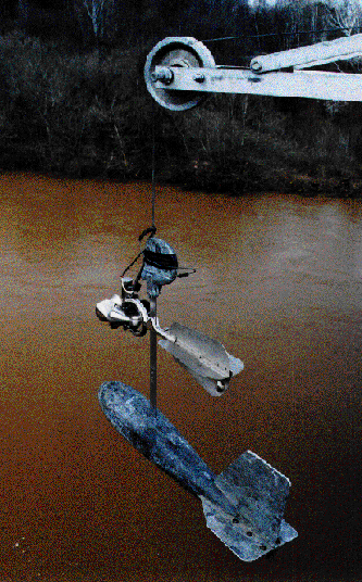
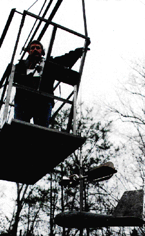
Photo 1 (92Kb). Current meter and weight suspended from a bridge crane.
Measuring the average velocity of an entire cross section is impractical, so the method uses an incremental method. The width of the stream is divided into a number of increments; the size of the increments depends on the depth and velocity of the stream. The purpose is to divide the section into about 25 increments with approximately equal discharges. For each incremental width, the stream depth and average velocity of flow are measured. For each incremental width, the meter is placed at a depth where average velocity is expected to occur. That depth has been determined to be about 0.6 of the distance from the water surface to the streambed when depths are shallow. When depths are large, the average velocity is best represented by averaging velocity readings at 0.2 and 0.8 of the distance from the water surface to the streambed. The product of the width, depth, and velocity of the section is the discharge through that increment of the cross section. The total of the incremental section discharges equals the discharge of the river.
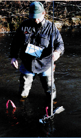
Photo 2 (81Kb). Wading rod and current meter used for measuring the discharge of a river.
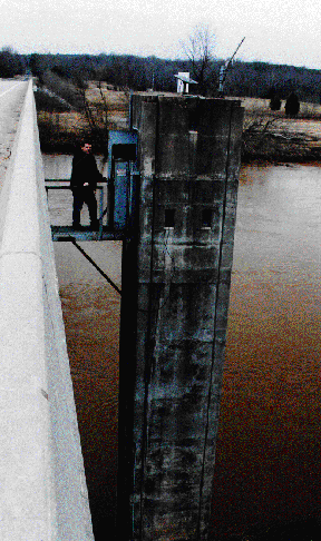
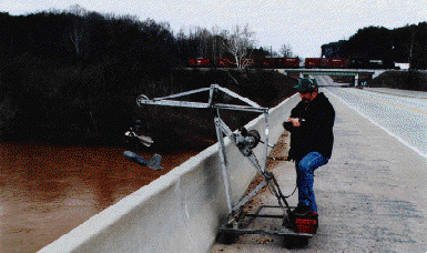
Photo 3 (40Kb). Crane, current meter, and weight used for measuring the discharge of a river from a bridge.
When the stage is low and the stream can be waded, the measurements are made by wading with the current meter mounted on a wading rod. The meter is positioned at the appropriate depth on the wading rod, which also is used to measure the water depth. If the water is too deep for wading, then the measurement is made either from a bridge or cableway across the stream. If the measurement is made from a bridge or cableway, then the meter is suspended on a thin cable wound on a reel. A torpedo-shaped weight is attached below the meter to permit it to be lowered into the water and to hold it in position once submerged. If measuring from a bridge, then the reel is mounted on a wheeled frame (or crane) that permits the lowering of the meter assembly over the bridge rail; from a cableway, the reel is mounted in a cable car suspended from the cableway that crosses the river.
Cover Photo 2 (50Kb GIF). Cable car, current meter, and weights used for measuring the discharge of a river from a cableway.
The basic procedure of measuring width and velocity is the same, however, whether the measurement is made by wading or from a cableway or bridge. The USGS makes more than 60,000 discharge measurements each year. The distribution of measurements made in 1993 is shown in figure 11.
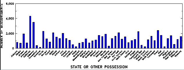
Figure 11.Discharge measurements made in 1993, by State or possession.
The stage-discharge relation will be stable if the hydraulic characteristics of the general reach of stream are unchanging and the bed material does not move appreciably. On a stable stream, periodic measurements are made every 6 to 8 weeks to verify that the relation has not undergone some unrecognized change. The stage-discharge relation will be unstable, changing with time and with the flow conditions, if the streambed or the hydraulic roughness is changing (as might occur with a sand-bed stream). In such cases, frequent measurements (about weekly) are needed to define how the rating is changing and to define its present condition (fig. 12).
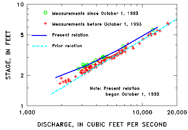
Figure 12. Sections of stage-discharge relations for the
Colorado River at the Colorado--Utah State line.
Sometimes, current-meter measurements are not possible during large floods. However, the stage and discharge of those floods are essential in defining the rating for the range of flow. Therefore, the discharge is determined indirectly by surveying the high-water marks left by the flood and by using hydraulic formulas to calculate the discharge for the peak stage.
Because the relation between stage and discharge may vary with time, the discharge is known only with certainty at the time of discharge measurements. If the relation is changing, then judgement must be used to determine the most probable status of the stage-discharge relation for times between discharge measurements. In fact, changes in the stage-discharge relation may not be evident until a whole series of measurements are available for analysis. Therefore, the computational process usually goes through the following steps:
Some data collected by other agencies, however, have value beyond the specific purpose for which the data were collected. Data from stations operated by other agencies are reviewed by the USGS, published in the annual State Water Data Reports series compiled by the USGS and entered in the USGS data base (see fig. 9). In 1990, data from about 400 stations were provided to the USGS by other agencies.
Before the introduction of the present publication series, water-resources data were published in USGS Water-Supply Papers. Before September 1960, data for each major river basin were published in annual Water-Supply Papers. From 1961 through 1970, the data for the major river basins were published in 5-year summaries.
Many streamflow-data users must make operational decisions daily. For these users, streamflow records are computed and made available on a provisional basis. Today, more than one-half of the currently operating stations have equipment that permits immediate transmission of data by means of satellite from the data-collection site. By using the telemetry, data are transmitted around the clock by means of two geostationary operations environmental satellites (GOES) that are positioned above the Earth at an altitude 22,300 miles above the Equator over the eastern Pacific Ocean and Brazil. The satellites are operated by the National Oceanic and Atmospheric Administration. These data then are retransmitted by means of a domestic satellite, and the resulting signal is received by the USGS and other users (fig. 13). The transmission and receipt of the signals are automated, as are the provisional discharge computations that are available for meeting current data needs.
Automated telemetry provides the water-data users with provisional stage and discharge information in a timeframe that meets water-management needs. This technology permits the USGS field offices to monitor the operation of the hydrologic stations continuously, time visits to stations to coincide with times of maximum need for data (such as during floods), and to service equipment at the stations.
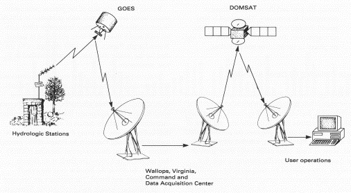
Figure 13. Schematic of the data flow for realtime operations.
Beginning with the 1990 water year, Water Data Reports also are available on Compact Disk--Read Only Memory (CD--ROM). The Water-Supply Papers, the Water Data Reports, and the CD--ROM's are distributed to participating agencies and libraries; they also are available for sale by the USGS Earth Science Information Center, Denver, Colorado. The USGS currently is developing procedures to allow access to streamflow data by means of Internet. Historical mean daily-discharge data for about 18,500 stations will soon be available through this source. The USGS "Home Page" on the World Wide Web is
http://www.usgs.gov.
URL for this page is <URL=http://txwww.cr.usgs.gov/pubs/circular/1123/collection.html>