Contaminants in the Mississippi River
U.S. GEOLOGICAL SURVEY CIRCULAR 1133
Reston, Virginia, 1995
Edited by Robert H. Meade
Sampling the Big Rivers
Robert H. Meade, John A. Moody, and Herbert H. Stevens,
Jr.
History of the Study: 1987-92
This study of the Mississippi River and its tributaries began in 1987
when a group of scientists in the U.S. Geological Survey (USGS) joined
forces to pursue some of the intriguing research questions concerning
the transport and storage of contaminants in large rivers. The
assemblage of researchers included hydrologists, chemists, physicists,
sedimentologists, and geologists who collectively had enough aggregate
expertise to begin a study of the continent's largest river. At least
three research questions piqued the collective interests of the group
and were amenable to a multidisciplinary approach: (1) How are
contaminants partitioned between the dissolved and adsorbed
phases-that is, does the contaminant travel in the river in true
solution (as salt is dissolved in sea water) or does it travel
piggyback, adsorbed onto the particles of sediment that are suspended
in the river? (2) How do contaminants, dissolved or adsorbed, mix at
large river confluences? (3) How are sediments and their adsorbed
contaminants stored and remobilized in big rivers? In addition to the
research results of these questions, a principal outcome of the study
was an assessment of the status of selected contaminants in the
Mississippi River. In the course of pursuing research goals in a
riverwide context, making repeated sampling trips at different seasons
of the year, a body of information inevitably accumulated that could
shed new light on the levels of many contaminants in the river. This
assessment, rather than the original research goals, is the subject of
the present report.
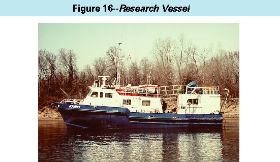
Research Vessel
 (Click on image for a larger version, 66K)
Figure 16. -- A program to sample a river as large as the
Mississippi (specifically, a total length of 2,800 river kilometers between
the uppermost station near Minneapolis/St. Paul and the lowermost station
below New Orleans) is best carried out aboard a ship that can serve
simultaneously as sampling platform, laboratory, and dormitory. The ship
that filled all these functions was Research Vessel (R/V) Acadiana, owned
and operated by the Louisiana Universities Marine Consortium. Acadiana is
17 meters long, 5.5 meters wide, and has a shallow enough draft (1.2
meters) to operate in most parts of the Mississippi River and in many of
its major tributaries. In the configuration shown here, Acadiana has two
onboard laboratories and bunk space for seven scientists plus a crew of
two.
During the first 3 years of the study, July 1987 to June 1990, seven
research and sampling cruises were made aboard the research vessel,
Acadiana. Sampling usually began at Winfield, Missouri, 100
kilometers upstream from St. Louis and 30 and 70 kilometers,
respectively, upstream from the confluences of the Mississippi with
the Illinois and Missouri Rivers. Downriver from Winfield, the
primary strategy was to sample the Mississippi main stem and several
of the major tributaries (Illinois, Missouri, Ohio, White, Arkansas,
and Yazoo Rivers) in a downstream sequence, trying to follow
approximately the same mass of water downriver. Although we did not
always succeed in following the same mass of water, we usually were
able to observe the changes that occurred in the water after the
Mississippi had received inflows from the major tributaries or after
the water and its load of sediment and contaminants had traveled
several hundred kilometers downstream. The initial phases of the
study were focused on the Lower Mississippi River, downriver of the
navigational locks and dams, because of the availability of new
techniques for sampling the freely flowing waters of large rivers and
because of our initial reluctance to deal with the extra complexity of
the transport and deposition of contaminants in a river that was
impounded by a series of large dams.
All this was to change during 1990. During the second half of 1988,
after the first three of our sampling cruises had been completed, the
Greenpeace ship Beluga conducted a well-publicized trip along the
Illinois and Mississippi Rivers and, in December 1989, Greenpeace
released its report, "We All Live Downstream: The Mississippi River
and the National Toxics Crisis". In January 1990, the USGS was
contacted by the office of then Senator Rudy Boschwitz of Minnesota,
who asked the USGS to extend its existing study into the Upper
Mississippi River, especially into the reach of the river between St.
Louis and The Twin Cities of Minneapolis and St. Paul, and produce a
report summarizing our results. Soon thereafter, members of Congress
from other States along the Mississippi-Arkansas, Illinois, Iowa,
Louisiana, Missouri, Tennessee, Wisconsin-joined Senator Boschwitz in
his request.
The response to this request was a change in the goals of our program
from mainly research to mainly assessment, and an expansion of the
scope of the program to include the much different hydrologic setting
of the upper river. This expansion required an augmentation of the
primary strategy for sampling the contaminants carried by the flowing
waters to include a second strategy for sampling the contaminants that
were stored with the sediment deposited on the bottoms of the
navigation pools of the Upper Mississippi.
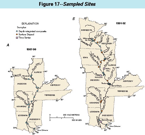
Sampled Sites
 (Click on image for a larger version, 66K)
Figure 17. -- The flowing waters of the Mississippi
River and its principal tributaries were sampled repeatedly at
critical sites during our studies.
-
A
-
During 1987-90, our studies focused on the lower and middle
reaches of the Mississippi River-from the vicinity of its confluences
with the Illinois and Missouri Rivers to a point a few kilometers
below New Orleans.
-
B
-
During 1991-92, the emphasis shifted to the Upper Mississippi River,
while the sampling of the Lower Mississippi was continued at a reduced
number of sites. Furthermore, time-series samples were collected at
three sites on the Mississippi River and at three sites on major
tributaries.
Sampling the Flowing Waters
The flowing waters of the big rivers are sampled to measure the
contaminants transported in solution as well as the contaminants
adsorbed onto the sediment particles suspended in the water. To
measure a dissolved contaminant being transported by the river, one
needs to know: (1) the water discharge (expressed as the number of
cubic meters of water that flows by a point along the river each
second); and (2) the concentration of the contaminant (expressed as
the number of grams per cubic meter of water). By multiplying
discharge times concentration, one obtains what is called "load," or
the number of grams of dissolved contaminant flowing downriver each
second. To measure a contaminant adsorbed on suspended sediment, one
needs to know: (1) the water discharge; (2) the concentration of
suspended sediment (expressed as the number of kilograms per cubic
meter of water); and (3) the concentration of the adsorbed contaminant
(expressed as grams of contaminant per kilogram of suspended
sediment). The load of adsorbed contaminant (grams per second or tons
per day) is the product of water discharge times suspended-sediment
concentration times contaminant concentration.
Two principal methods were used to collect water samples for
determining concentrations and loads. Both methods take into
consideration that the velocity of flow and the concentrations of
suspended sediment and even dissolved matter are not distributed
uniformly across the widths of large rivers. Flow velocities usually
are greatest at the river surface in midstream and they decrease
toward the bottom and banks of the river. Sediment concentrations
usually are greatest near the river bottom and smallest at the river
surface. After large tributaries enter the Mississippi, their waters
may not mix thoroughly for 100-200 km downstream. Were it not for
these inhomogeneities, one simply could dip a bottle or bucket into
the middle of the flowing river, analyze the water collected, and
multiply the concentrations times the discharge to calculate the
loads. Indeed, this simple method has been used around the world for
many years to sample the chemical compositions of rivers large and
small. But the results of this sampling approach cannot be evaluated
for their accuracy because the point at the centroid of water flow and
the point where the contaminant concentration is the representative
average of a river cross section are seldom obvious, unless extensive
sets of detailed measurements have been collected beforehand.
Our standard method of collecting representative amounts of river
water for the analysis of contaminant loads samples the full depth and
width of the river. By this method, a sampler is lowered to the
bottom of the river and raised back to the surface, collecting water
through the full depth of the river, at a number of locations spaced
equidistantly across the river from bank to bank. The resulting
sample is called a depth-integrated composite. The sampler is
designed to admit water at the velocity at which it is flowing in the
river, and the sampler travels to the bottom and back at the same
vertical speed each time. It collects the most water where the river
flows fastest and deepest, and the least water where the river flows
slowest and shallowest; the resulting sample is thereby weighted for
water discharge. This method has been the standard for many years for
sampling smaller rivers. Scaling it up for larger rivers such as the
Mississippi is simple in principle but has proven more complicated in
actual practice. Working from a moving ship in flowing water requires
microwave positioning equipment or some other means of finding and
maintaining the appropriate locations for collecting samples in a
cross section of the river. A specially designed hydraulic winch and
a sampler consisting of an initially collapsed Teflon bag inside a
plastic bottle are required to collect the fast and deep waters of the
Mississippi. Deploying the navigation equipment, positioning the
ship, and collecting a representative sample in sufficient volume for
all the required analyses usually kept the ship's crew and half a
dozen scientists busy for the better part of a day at most of our
sampling cross sections.
Sampling Flowing Waters
 (Click on image for a larger version, 99K)
Figure 18. -- Obtaining representative samples of the
flowing waters of the Mississippi River and its larger tributaries required
special procedures and equipment, some of which are illustrated here.
-
A
-
In a typical cross section of the Mississippi River, representative
amounts of water were collected, through the full river depth from the
surface to the bottom, at locations spaced at approximately equal
intervals across the river. All the water collected at the locations
across the river was combined into a single composite sample. At many
cross sections, two separate composites (shown here as red and yellow)
were collected so comparisons could be made to assess the precision of
the sampling procedure.
-
B
-
Sampling from a freely moving vessel in a large river requires
a precise means of determining the location and motion of the vessel.
Microwave positioning equipment served that purpose. Shown in the
photograph is one of several remote units that were placed at known
positions on the riverbanks at or near the sampling sites. Aboard the
vessel (not shown in the photograph) was a master microwave unit that
measured the distances from the remote units and thereby determined
the relative position of the vessel.
-
C
-
The array of equipment for measuring water velocity and for sampling
the flowing waters and suspended sediment consisted of, from top to
bottom,
(1) a current meter, similar in design to the familiar anemometer
that is commonly used to measure windspeed,
(2) a sampling bottle, containing a collapsed Teflon bag (shown here
partly filled) that expanded as it received the incoming sample,
and fitted in front with an isokinetic nozzle that was designed
to admit water and suspended sediment in proportion to the
velocity at which they were moving in the river, and
(3) a sounding weight of either 150, 200, or 300 pounds-depending on
how fast and deep were the waters being sampled.
The hydraulic winch that was used to lower and raise the sampling
array is not shown in the photograph.
Sampling Navigation Pools
 (Click on image for a larger version, 99K)
Figure 19. -- The contaminants adsorbed to the
sediments deposited in the backwater areas of the navigation pools of
the Upper Mississippi River were sampled to obtain representative
average concentrations for each pool.
-
A
-
The Upper Mississippi River between Minneapolis/St. Paul and St. Louis
is segmented by 26 principal navigation pools.
-
B
-
A "typical" pool (Pool 8, in this example) consists of three parts:
an upper section, characterized by riverine channels and emergent
flood plains; a middle section, characterized by numerous islands,
parts of which are deltaic in origin but most of which are the
elevated areas of the flood plains that flanked the river channels
before the pool was inundated; a lower section, characterized by a
shallow expanse of open water.
-
C
-
Sampling was concentrated in the lower sections of the pools (Pool 8
is again the example)-outside the main navigation channel-because this
is where fine-grained sediments and their adsorbed contaminants are
most likely to be stored. Samples were collected at 15-20 locations
per pool (shown here as three linear rows of white dots), which was
sufficient to obtain a representative average, without seeking either
"hotspots" or pristine areas.
Representative small amounts of the depth-integrated composite were
taken for the analysis of such things as herbicides, surfactants,
dissolved heavy metals, and suspended sediment. The bulk of the
depth-integrated sample was passed first through a centrifuge and then
through an ultrafiltration apparatus to separate most of the water
from the suspended sediment in preparation for chemical analysis for
adsorbed heavy metals and other inorganic constituents. Every gram of
suspended sediment that was recovered this way required processing
from 5 to 100 liters of river water: 5 to 10 liters in most places in
the Lower Mississippi where sediment concentrations are moderate to
large; 50 to 100 liters of water in some places in the Upper
Mississippi (downriver of Lake Pepin, especially) where concentrations
are very small.
Our second principal method for collecting the flowing waters was by
pumping them directly out of the river. Because the analyses for some
of the adsorbed contaminants required larger quantities of suspended
sediment than we were able to recover by depth-integrated sampling, we
adopted the more expedient method of pumping water from the river,
usually from a depth halfway between the surface and bottom. The
pumping method collected 5 to 10 times the amount of water that could
be collected in the same time by the depth-integrated sampling.
Consequently, 5 to 10 times the amount of suspended sediment could be
recovered, making it increasingly possible to measure many of the
industrial and other contaminants that are difficult to detect on
small quantities of sediment. The quantities of water pumped in the
different parts of the channel were proportional to the water
discharges there. The disadvantage of the pumping method is that it
does not sample the full depth of the river. However, because
depth-integrated samples were being collected at the same time at the
same locations, comparative studies were made to show that, for the
suspended particles with which contaminants are preferentially
associated, the pumped sample was accurately representative of what
was being transported in the full depth of the river. A typical
pumped sample was somewhere between 500 and 1,000 liters (one-half ton
to a ton, that is) of river water, which required 6 to 10 hours to
collect and many more hours of shipboard processing to separate all
the water from the suspended sediment.
Despite its disadvantages, a secondary method of dipping bottles into
the surfaces of the rivers was used to obtain some samples. This
sampling method was used most consistently in the tributaries of the
Upper Mississippi River that were too shallow to be navigated by R/V
Acadiana and had to be sampled from a small boat. The procedure
consisted simply of dipping bottles into the tributaries near their
estimated centroids of water discharge. The concentrations of
contaminants in these surface-dipped samples are useful for computing
approximate downriver loads, so long as the contaminant is transported
in solution and the river waters being sampled are well mixed from top
to bottom and from bank to bank. In other circumstances, the
concentrations of surface-dipped samples may be more indicative than
definitive.
Sampling Bed Sediments
 (Click on image for a larger version, 99K)
Figure 20. -- The sediments and their adsorbed
contaminants on the bottoms of the navigational pools of the Upper
Mississippi River were sampled by fairly traditional means.
-
A and B
-
The shallow backwater areas of most of the navigation pools
were sampled from a small boat. Sampling equipment consisted of a
clamshell grab (midboat) and gravity corer (forward). Also measured
were current velocity (aft) and the position of the boat (microwave
unit atop the pole).
-
C
-
In the deeper pools such as Pool 19 (shown here) or Lake Pepin,
bottom-sediment samples were collected directly from Research Vessel
Acadiana.
-
D
-
From the sediment recovered in the clamshell grab, separate subsamples
were taken for the analysis of organic constituents such as PCBs and
coprostanol. Samples for heavy-metal analysis were taken separately
with a plastic gravity corer so as to avoid any error caused by the
introduction of extraneous metal from the sampling equipment
itself.
Sampling the Stored Sediments in the Pools of the Upper River
The Upper Mississippi River between St. Louis and Minneapolis/St. Paul
is controlled, mostly for navigation, by a series of 29 locks and
dams, and its hydrologic characteristics are markedly different from
those of the freely flowing middle and lower river between St. Louis
and the Gulf of Mexico. Each dam between Minneapolis and St. Louis
artificially deepens, widens, and slows the river above it, allowing
sediment to settle in the pool that forms behind the dam. These pools
form a series of small lakes that trap and store some of the sediment
and adsorbed contaminants that are being transported downriver. How
much of the incoming contaminant load is stored in one of these pools,
or for how long, depends on a number of things: the size and shape of
the pool, how often the pool is flushed by large floods, and whether
the contaminant in question is transported in solution or is adsorbed
onto sediment particles. In general, the contaminants most likely to
remain in storage are those adsorbed onto sediment particles that have
been deposited in the backwater areas of large pools.
The contaminants adsorbed onto the sediments stored in the pools of
the Upper Mississippi River were sampled by conventional means. A
clamshell grab and a small plastic corer were used to collect samples
of the uppermost 10 cm of the silt or mud that lay on the bottom at 15
to 20 places in the shallow or backwater areas of the navigation
pools. In only the two largest pools, Lake Pepin and Pool 19, were
the waters sufficiently deep to allow the bed samples to be collected
directly from Acadiana. In the remainder of the pools, samples were
collected over the side of a 14-foot-long boat. The locations in the
pools where the samples were collected were fixed by their distances
(determined by microwave-distancing equipment) and bearings from
objects or landmarks whose positions were known. Sampling the stored
bed sediments of a pool took four people most of a day. Equal
quantities of each of the 15 to 20 grab samples collected in each pool
were combined into a single batch sample for analysis of organic
compounds such as PCBs and sewage contaminants such as coprostanol.
Core samples were kept separate for individual analyses for heavy
metals.
Sampling the Length of the River
A third major strategy employed in this study was longitudinal sampling
along the center line of the river. This was an opportunistic strategy
that exploited the long traverse that Acadiana had to make at the
beginning of each sampling cruise from her home port near New Orleans,
Louisiana, to the farthest upriver point where the regular downriver
sampling was begun (Winfield, Missouri, or Minneapolis, Minnesota). On the
upriver traverse, the vessel took 10-11 days to reach Minneapolis,
depending on the strength of the river currents. So as not to waste this
opportunity to sample the river continually along its full length, a
strategy was devised whereby the vessel was slowed down sufficiently every
10 miles or so to collect samples of water from about a meter below the
river surface. Samples usually were taken in the middle of the river, but,
where the waters were not well mixed (below major tributary confluences,
for example), samples were collected at several points across the river.
This procedure would not have been valid for sampling constituents
associated with sediment particles, but it provided unique information on
the spatial and temporal distributions of such compounds as herbicides and
dissolved sewage contaminants.
Time-Series Sampling at Fixed Locations
A limited number of contaminants were sampled at fairly frequent intervals, usually once or twice a week, for limited periods at fixed
stations on the Mississippi River and some of its tributaries. The
specific contaminants that were sampled in this manner were herbicides
and nutrients, for which the Mississippi River main stem was sampled
at Clinton, Iowa, Thebes, Illinois, and Baton Rouge, Louisiana.
Tributaries sampled in this manner were the Illinois, Missouri, and
Ohio Rivers.
Further Information
More detailed accounts of the procedures used to sample the Mississippi
River are given in the following reports.
- Leenheer, J.A., Meade, R.H., Taylor, H.E., and Pereira, W.E.,
1989,
- Sampling, fractionation, and dewatering of suspended sediment
from the Mississippi River for geochemical and trace-contaminant
analysis, in Mallard, G.E., and Ragone, S.E., eds., U.S.
Geological Survey Toxic Substances Technical Meeting, Phoenix, Arizona:
U.S. Geological Survey Water-Resources Investigations Report 88-4220, p.
501-511.
- Meade, R.H., and Stevens, H.H., Jr., 1990,
- Strategies and equipment
for sampling suspended sediment and associated toxic chemicals in
large rivers-with emphasis on the Mississippi River: The Science of
the Total Environment, v. 97/98, p. 125-135.
- Moody, J.A., 1993,
- Evaluation of the Lagrangian scheme for sampling
the Mississippi River during 1987-90: U.S. Geological Survey
Water-Resources Investigations Report 93-4042, 31 p.
- ___ ed., 1995,
- Chemical data for water samples collected during four
upriver cruises on the Mississippi River between New Orleans,
Louisiana, and Minneapolis, Minnesota, May 1990-April 1992:
U.S. Geological Survey Open-File Report 94-523, 297 p.
- ___ ed., 1995,
- Hydrologic, sedimentologic, and chemical data
describing surficial bed sediments in the navigation pools of the
Upper Mississippi River, July 1991-April 1992: U.S. Geological Survey
Open-File Report 95-708.
- Moody, J.A., and Meade, R.H., 1992,
- Hydrologic and sedimentologic data
collected during three cruises at low water on the Mississippi River
and some of its tributaries, July 1987 through June 1988:
U.S. Geological Survey Open-File Report 91-485, 143 p.
- ___ 1993,
- Hydrologic and sedimentologic data collected during four
cruises at high water on the Mississippi River and some of its
tributaries, March 1989 through June 1990: U.S. Geological Survey
Open-File Report 92-651, 227 p.
- ___ 1994,
- Evaluation of the method of collecting suspended sediment
from large rivers by discharge-weighted pumping and separating it by
continuous-flow centrifugation: Hydrological Processes, v. 8,
p. 513-530.
- ___ 1995,
- Hydrologic and sedimentologic data collected during three
cruises on the Mississippi River and some of its tributaries from
Minneapolis, Minnesota, to New Orleans, Louisiana, July 1991-May 1992:
U.S. Geological Survey Open-File Report 94-474, 159 p.
- Moody, J.A., and Troutman, B.M., 1992,
- Evaluation of the
depth-integration method of measuring water discharge in large rivers:
Journal of Hydrology (Amsterdam), v. 135, p. 201-236.
- Rees, T.F., Leenheer, J.A., and Ranville, J.F., 1991,
- Use of a
single-bowl continuous-flow centrifuge for dewatering suspended
sediments-Effect on sediment physical and chemical characteristics:
Hydrological Processes, v. 5, p. 201-214.
Continue to '
Heavy metals in the Mississippi River
', or return to '
Contents
'
Contaminants in the Mississippi River
U.S. GEOLOGICAL SURVEY CIRCULAR 1133
Reston, Virginia, 1995
Edited by Robert H. Meade
http://water.er.usgs.gov/pubs/circ1133/big-sample.html
Maintainer:
h2o Webserver Team
Last Modified: 1230 01 Oct 96 ghc
 (Click on image for a larger version, 66K)
 (Click on image for a larger version, 99K)
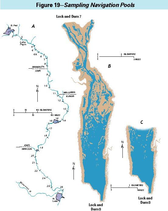 (Click on image for a larger version, 99K)
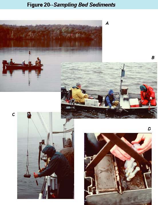 (Click on image for a larger version, 99K)