K
Field Studies of Glacial and Dune Terrain
Glacial terrain and dune terrain are characterized by land-surface depressions, many of which contain lakes and wetlands. Although much of the glacial terrain covering the north-central United States (see index map) has low topographic relief, neighboring lakes and wetlands are present at a sufficiently wide range of altitudes to result in many variations in how they interact with ground water, as evidenced by the following examples.
The Cottonwood Lake area, near Jamestown, North Dakota, is within the prairie-pothole region of North America. The hydrologic functions of these small depressional wetlands are highly variable in space and time. With respect to spatial variation, some wetlands recharge ground water, some receive ground-water inflow and have outflow to ground water, and some receive ground-water discharge. Wetland P1 provides an example of how their functions can vary in time. The wetland receives ground-water discharge most of the time; however, transpiration of ground water by plants around the perimeter of the wetland can cause water to seep from the wetland. Seepage from wetlands commonly is assumed to be ground-water recharge, but in cases like Wetland P1, the water is actually lost to transpiration. This process results in depressions in the water table around the perimeter of the wetland at certain times, as shown in Figure K-1. Transpiration-induced depressions in the water table commonly are filled in by recharge during the following spring, but then form again to some extent by late summer nearly every year.
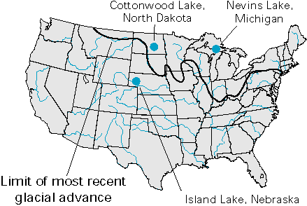 |
Nevins Lake, a closed lake in the Upper Peninsula of Michigan, illustrates yet another type of interaction of lakes with ground water in glacial terrain. Water-chemistry studies of Nevins Lake indicated that solutes such as calcium provide an indicator of ground-water inflow to the lake. Immediately following spring snowmelt, the mass of dissolved calcium in the lake increased rapidly because of increased ground-water inflow. Calcium then decreased steadily throughout the summer and early fall as the lake received less ground-water inflow (Figure K-2). This pattern varied annually depending on the amount of ground-water recharge from snowmelt and spring rains. The chemistry of water in the pores of the lake sediments was used to determine the spatial variability in the direction of seepage on the side of the lake that had the most ground-water inflow. Seepage was always out of the lake at the sampling site farthest from shore and was always upward into the lake at the site nearest to shore. Flow reversals were documented at sites located at intermediate distances from shore.
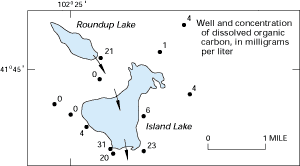
Dune terrain also commonly contains lakes and wetlands. Much of the central part of western Nebraska, for example, is covered by sand dunes that have lakes and wetlands in most of the lowlands between the dunes. Studies of the interaction of lakes and wetlands with ground water at the Crescent Lake National Wildlife Refuge indicate that most of these lakes have seepage inflow from ground water and seepage outflow to ground water. The chemistry of inflowing ground water commonly has an effect on lake water chemistry. However, the chemistry of lake water can also affect ground water in areas of seepage from lakes. In the Crescent Lake area, for example, plumes of lake water were detected in ground water downgradient from the lakes, as indicated by the plume of dissolved organic carbon downgradient from Roundup Lake and Island Lake (Figure K-3).
Figure K-1: Transpiration directly from ground water causes cones of depression to form by late summer around the perimeter of prairie pothole Wetland P1 in the Cottonwood Lake area in North Dakota. (Modified from Winter, T.C., and Rosenberry, D.O., 1995, The interaction of ground water with prairie pothole wetlands in the Cottonwood Lake area, east-central North Dakota, 1979-1990: Wetlands, v. 15, no. 3, p. 193-211.) (Used with permission.)
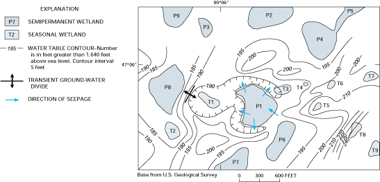
Figure K-2: A large input of ground water during spring supplies the annual input of calcium to Nevins Lake in the Upper Peninsula of Michigan. (Modified from Krabbenhoft, D.P., and Webster, K.E., 1995, Transient hydrogeological controls on the chemistry of a seepage lake: Water Resources Research, v. 31, no. 9, p. 2295-2305.)
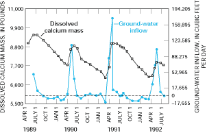
Figure K-3: Seepage from lakes in the sandhills of Nebraska causes plumes of dissolved organic carbon to be present in ground water on the downgradient sides of the lakes. (Modified from LaBaugh, J.W., 1986, Limnological characteristics of selected lakes in the Nebraska sandhills, U.S.A., and their relation to chemical characteristics of adjacent ground water: Journal of Hydrology, v. 86, p. 279-298.) (Reprinted with permission of Elsevier Science-NL, Amsterdam, The Netherlands.)