L
Field Studies of Karst Terrain
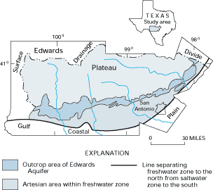
Karst terrain is characteristic of regions that are underlain by limestone and dolomite bedrock. In many karst areas, the carbonate bedrock is present at land surface, but in other areas it may be covered by other deposits and is referred to as "mantled" karst. The Edwards Aquifer in south-central Texas is an example of karst terrain where the limestones and dolomites are exposed at land surface (Figure L-1). In this outcrop area, numerous solution cavities along vertical joints and sinkholes provide an efficient link between the land surface and the water table. Precipitation on the outcrop area tends to infiltrate rapidly into the ground, recharging ground water. In addition, a considerable amount of recharge to the aquifer is provided by losing streams that cross the outcrop area. Even the largest streams that originate to the north are dry in the outcrop area for most of the year. The unusual highway signs in this area go beyond local pride in a prolific water supply-they reflect a clear understanding of how vulnerable this water supply is to contamination by human activities at the land surface.
Just as solution cavities are major avenues for ground-water recharge, they also are focal points for ground-water discharge from karst aquifers. For example, springs near the margin of the Edwards Aquifer provide a continuous source of water for streams to the south.
Figure L-1: A large area of karst terrain is associated with the Edwards Aquifer in south-central Texas. Large streams lose a considerable amount of water to ground water as they traverse the outcrop area of the Edwards Aquifer. (Modified from Brown, D.S., and Patton, J.T., 1995, Recharge to and discharge from the Edwards Aquifer in the San Antonio area, Texas, 1995: U.S. Geological Survey Open-File Report 96-181, 2 p.)
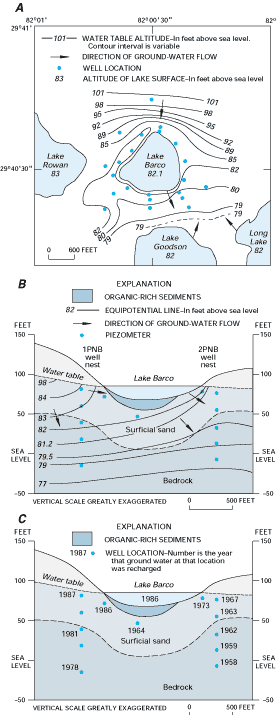
An example of mantled karst can be found in north-central Florida, a region that has many sinkhole lakes. In this region, unconsolidated deposits overlie the highly soluble limestone of the Upper Floridan aquifer. Most land-surface depressions containing lakes in Florida are formed when unconsolidated surficial deposits slump into sinkholes that form in the underlying limestone. Thus, although the lakes are not situated directly in limestone, the sinkholes in the bedrock underlying lakes commonly have a significant effect on the hydrology of the lakes.
 |
Lake Barco is one of numerous lakes occupying depressions in northern Florida. Results of a study of the interaction of Lake Barco with ground water indicated that shallow ground water flows into the northern and northeastern parts of the lake, and lake water seeps out to shallow ground water in the western and southern parts (Figure L-2A). In addition, ground-water flow is downward beneath most of Lake Barco (Figure L-2B).
The studies of lake and ground-water chemistry included the use of tritium, chlorofluorocarbons (CFCs), and isotopes of oxygen (see Box G). The results indicated significant differences in the chemistry of (1) shallow ground water flowing into Lake Barco, (2) Lake Barco water, (3) shallow ground water downgradient from Lake Barco, and (4) deeper ground water beneath Lake Barco. Oxygen-rich lake water moving through the organic-rich lake sediments is reduced, resulting in discharge of oxygen-depleted water into the ground water beneath Lake Barco. This downward-moving ground water may have an undesired effect on the chemical quality of ground water in the underlying Upper Floridan aquifer, which is the principal source of water supply for the region. The patterns of ground-water movement determined from hydraulic-head data were corroborated by chemical tracers. For example, the dates that ground water in different parts of the flow system was recharged, as determined from CFC dating, show a fairly consistent increase in the length of time since recharge with depth (Figure L-2C).
Figure L-2: Lake Barco, in northern Florida, is a flow-through lake with respect to ground water (A and B). The dates that ground water in different parts of the ground-water system was recharged indicate how long it takes water to move from the lake or water table to a given depth (C). (Modified from Katz, B.G., Lee, T.M., Plummer, L.N., and Busenberg, E., 1995, Chemical evolution of groundwater near a sinkhole lake, northern Florida, 1. Flow patterns, age of groundwater, and influence of lake water leakage: Water Resources Research, v. 31, no. 6, p. 1549-1564.)