![]()
Rich grasslands and forested canyons inspired 19th-century cattle ranchers to make the Central Columbia Plateau their home. As overgrazing devalued the land for ranching, farming became more important. Today it is an area of national agricultural importance and home to about 300,000 people. The region is one of the Nation's top two producers of potatoes and wheat, is a significant producer of apples and many other crops, and supports much rangeland grazing.
The Study Unit was divided into three subunits on the basis of hydrologic and geologic differences affecting land and water use (see p. 24 - 25 ). Thick loess and moderate precipitation allow for dryland farming in the Palouse subunit, while the Columbia Basin Irrigation Project has made the Quincy-Pasco subunit also productive for farming. The North-Central subunit supports rangeland grazing and, where conditions allow, irrigated and dryland farming.
 (38,483 bytes)
Figure 1. Most of the land in the Central Columbia Plateau is used for agriculture.
Table 1. Summary of subunit characteristics [mi2, square mile; %, percent]
|
Controlled during irrigation season (Mar.-Oct.) |
Intermittent streams with few |
||
|
Feedlots, pesticide handling areas |
|||
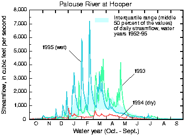
The arid to semiarid climate is evident in the hydrology. Only the Palouse subunit receives enough rainfall (fig. 2) to support perennial streams that have high flows in the wetter winter months and low base flows in the dry, hot summer months (fig. 3). Before increased irrigation, the remainder of the Study Unit mostly supported intermittent streams that only had substantial streamflows following storms; this is still true for most of the North-Central subunit.
 (11,690 bytes)
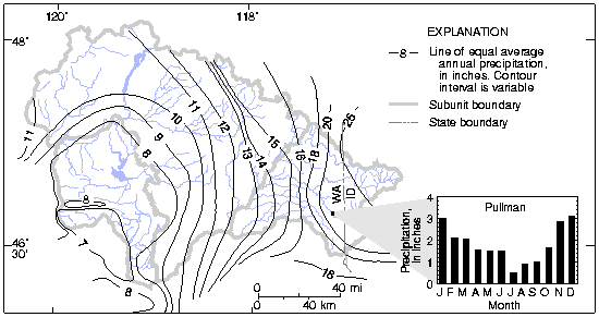
Figure 2. Average annual precipitation is highest in the Palouse subunit; average monthly figures for Pullman, Wash., show that precipitation mostly occurs in the winter (years of record 1956-77). Modified from [4].
 (6,625 bytes)
Figure 3. Conditions in the Palouse subunit were typical during 1993-95, the sampling period, with variable streamflows in dry, average, and wet years.
 (9,322 bytes)
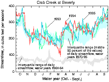
Figure 4. In the Quincy-Pasco subunit, irrigation has increased and stabilized streamflows throughout the year.
Irrigation in the Quincy-Pasco subunit increased significantly during 1955-75 as the Columbia Basin Irrigation Project made more water available. Water diverted from the Columbia River, conveyed through irrigation canals, and applied to agricultural lands has raised the water table tens to hundreds of feet, creating or increasing base flow to many of the streams and wasteways. The result is an overall annual increase in streamflow, controlled mostly by irrigation, with base flow in the winter and high flows in the summer ( fig. 4 ).
About 94 percent of combined ground- and surface-water withdrawals are for irrigation [5]. Eighty-four percent of public and domestic supplies comes from ground water (fig. 5).
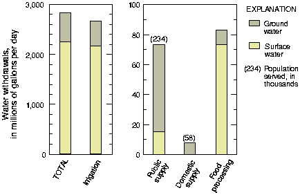
Figure 5. Most of the water in the Central Columbia Plateau is used for irrigation. Ground water is the main source of drinking water (1990 data shown; graphs have different vertical scales) [ 5 ].