![]()
Water Quality in the Western Lake Michigan Drainages, Wisconsin and Michigan, 1992-95
Table of contents || Previous section || Next section || Glossary
 (96,087 bytes)
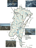
Basemap of the Western Lake Michigan Drainages Study Unit with photos.
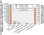
The Western Lake Michigan Drainages Study Unit drains a 20,000-square-mile area in eastern Wisconsin and the Upper Peninsula of Michigan. The study area is comprised of the Fox-Wolf, Milwaukee, Menominee, Oconto, and Peshtigo River Basins in Wisconsin and the Ford and Escanaba River Basins in Michigan.
The overall population in the study area is about 2,435,000 (U.S. Department of Commerce, 1991). Major cities include Milwaukee, Green Bay, Racine, and Appleton. The Green Bay area, along the lower Fox River, has one of the highest densities of paper mills in the world. Lake Winnebago, a 137,000-acre lake in the Fox River Basin, is a major surface-water feature.
The primary water-quality issues in the study area include contamination and nutrient enrichment of surface water and ground water by agricultural chemicals, contamination of bed sediments of rivers and harbors by toxic substances, contamination and nutrient enrichment of rivers and lakes from industrial and municipal waste discharges, and acidification and mercury contamination of lakes and wetlands in the forested part of the study area
|
|
|
|
|
|
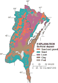
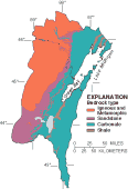
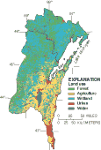
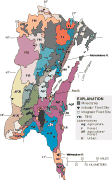
Water quality in the Western Lake Michigan Drainages is affected by natural and anthropogenic factors. In order to study the important water-quality issues, the basin was divided into 28 relatively homogeneous units (RHUs) with unique combinations of land use, surficial-deposit texture, and bedrock by overlaying digital thematic maps (p. 5) of these land features (Robertson and Saad, 1995).
Not all of the 28 RHUs could be sampled; therefore, specific RHUs were selected for sampling on the basis of the major water-quality issues in the RHU. Eleven stream sites, called Fixed Sites, were chosen to describe the variability in streamflow and concentrations of nutrients, major ions, suspended sediment, and biological communities. Eight of the 11 Fixed Sites were Indicator Sites, sites selected to represent the quality of water draining from a specific RHU. Four Indicator Sites were on streams representing agricultural RHUs, two were on streams representing forested RHUs, and one each was on a stream representing an urban RHU and a mixed agriculture and forest RHU. The remaining three sites were Integrator Sites, sites located near the mouths of major rivers, where water quality is affected by various combinations of land use, surficial deposits, and bedrock geology. Each of these 11 sites was sampled at least monthly for 2.5 years.
Additionally, short-term synoptic studies were done to better define the variability in water quality throughout the study area. Figures on p. 24 and the table on p. 25 provide details of those studies.
One of the synoptic studies was conducted to determine if monitoring results from the Indicator Fixed Sites were representative of specific RHUs and the basin as a whole. The Indicator Fixed Site data were compared to results from a study of 83 sites throughout the basin. Results of that study, conducted during base-flow conditions, indicate that the Indicator Fixed Sites provide a fair representation of specific RHUs and the entire basin.
Water quality in the Western Lake Michigan Drainages is affected by natural and anthropogenic factors. In order to study the important water-quality issues, the basin was divided into 28 relatively homogeneous units (RHUs) with unique combinations of land use, surficial-deposit texture, and bedrock by overlaying digital thematic maps (p. 5) of these land features (Robertson and Saad, 1995).
 (27,646 bytes)
Water quality in the Western Lake Michigan Drainages is affected by natural and anthropogenic factors.
Not all of the 28 RHUs could be sampled; therefore, specific RHUs were selected for sampling on the basis of the major water-quality issues in the RHU. Eleven stream sites, called Fixed Sites, were chosen to describe the variability in streamflow and concentrations of nutrients, major ions, suspended sediment, and biological communities. Eight of the 11 Fixed Sites were Indicator Sites, sites selected to represent the quality of water draining from a specific RHU. Four Indicator Sites were on streams representing agricultural RHUs, two were on streams representing forested RHUs, and one each was on a stream representing an urban RHU and a mixed agriculture and forest RHU. The remaining three sites were Integrator Sites, sites located near the mouths of major rivers, where water quality is affected by various combinations of land use, surficial deposits, and bedrock geology. Each of these 11 sites was sampled at least monthly for 2.5 years.
Additionally, short-term synoptic studies were done to better define the variability in water quality throughout the study area. Figures on p. 24 and the table on p. 25 provide details of those studies.
One of the synoptic studies was conducted to determine if monitoring results from the Indicator Fixed Sites were representative of specific RHUs and the basin as a whole. The Indicator Fixed Site data were compared to results from a study of 83 sites throughout the basin. Results of that study, conducted during base-flow conditions, indicate that the Indicator Fixed Sites provide a fair representation of specific RHUs and the entire basin.
 (6,716 bytes)
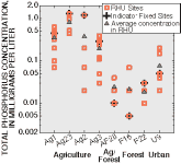
Indicator Fixed Site data are representative of the specific RHUs they were selected to represent (Robertson, 1998).
|
Fixed site (RHU) |
Area |
Land use (percent) |
Surficial deposit (percent) |
Bedrock |
|---|---|---|---|---|
|
Duck Cr. (Ag1) |
95 |
Agriculture (89) |
Clay (76) |
Carbonates |
|
Pensaukee R. (Ag2) |
36 |
Agriculture (86) |
Loam (99) |
Carbonates |
|
N. Br. Milwaukee R. (Ag3) |
51 |
Agriculture (88) |
Sand (89) |
Carbonates |
|
East R. (Ag23) |
47 |
Agriculture (92) |
Clay (95) |
Shale |
|
Tomorrow R. (AF20) |
44 |
Agriculture (58)/ |
Sand (39)/ |
Igneous/ |
|
Peshekee R. (F16) |
49 |
Forest (98) |
Loam (100) |
Igneous/ |
|
Popple R (F22) |
139 |
Forest (90) |
Sand (24)/ |
Igneous/ |
|
Lincoln Cr. (U9) |
10 |
Urban (100) |
Clay (100) |
Carbonates |
|
Menominee R. |
3,901 |
Integrator |
Integrator |
Integrator |
|
Fox R. |
6,035 |
Integrator |
Integrator |
Integrator |
|
Milwaukee R. |
688 |
Integrator |
Integrator |
Integrator |
Ground water studies were also designed to look at the effects of land use, surficial deposit texture, and bedrock geology on water-quality variability. Ground water from the Cambrian-Ordovician aquifer, the most-used drinking-water aquifer in the study area, and from shallow aquifers associated with agricultural land use and two different surficial deposits were sampled to indicate this variability.
Understanding hydrologic and climatic conditions is important for interpreting water-quality data. During wet-weather periods, runoff can carry materials into the stream from the land, and concentrations of nutrients, pesticides, and sediment can increase above those at normal streamflow. Periods of excessive precipitation can cause ground-water levels to rise, contributing a larger ground-water component to streamflow and causing changes in streamwater chemistry. During dry periods, point-source discharges to streams may degrade stream-water quality. The seasonal timing of precipitation can also affect stream-water quality. For example, precipitation causing runoff early in the growing season, before crops come up and after pesticides and fertilizers have been applied, can produce significant potential for water contamination.
 (8,188 bytes)
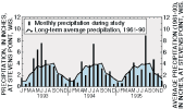
Precipitation varies seasonally with 60 percent occurring between May and September (Peters, 1997). The 1993 growing season was much wetter than normal and was the wettest period during the 3-year investigation.
 (62,945 bytes)
 (62,253 bytes)
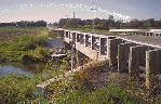
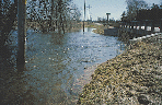
Extensive flooding occurred in the study area in the spring of 1993. These photos of the North Branch of the Milwaukee River were taken from near the same location (note location of bridge abutment) during normal flows in 1995 and during the spring 1993 floodflows.
 (8,563 bytes)
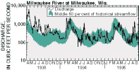
Annual discharge measured at the Milwaukee River in 1993 was the fourth largest recorded since the start of measurement (historical streamflow data covers the period of record from 1914-96).
The average precipitation in the Wisconsin part of the study area during all of 1993 was about 39 inches, or 122 percent of the 30-year statewide average. Annual runoff in 1993 ranged from 240 to 280 percent of normal in the southern part of the study area. Precipitation in the study area measured about 31 inches during 1994 and about 29 inches during 1995. Annual runoff was near normal during both years.
U.S. Geological Survey Circular 1156
Table of contents || Previous section || Next section || Glossary
Suggested citation:
C. A. Peters, D. M. Robertson, D. A. Saad, D. J. Sullivan, B. C. Scudder, F. A. Fitzpatrick, K. D. Richards, J. S. Stewart, S. A. Fitzgerald, and B. N. Lenz, 1998, U.S. Geological Survey Circular 1156, on line at <URL: https://water.usgs.gov/pubs/circ1156>, updated June 11, 1998