SUMMARY OF DATA COLLECTION IN THE ALBEMARLE-PAMLICO STUDY UNIT, 1992-95
|
Study
component
|
What data were collected
and why
|
Types of sites sampled
|
Number
of sites
|
Sampling frequency and period
|
|
Stream Chemistry
|
|
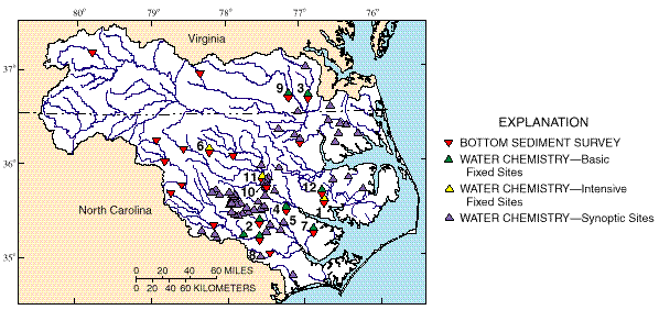
Bottom-sediment survey
|
Determine presence of potentially toxic compounds attached to sediments in major streams.
|
Sample depositional zones at selected sites basin- wide for trace elements and hydrophobic organic compounds.
|
22
|
1
(in 1992)
|
|
Water chemistry--
Basic Fixed Sites
|
Describe concentrations and loads of chemicals, suspended sediment, and nutrients at selected sites basinwide.
|
Sample at or near sites where streamflow is measured continuously for major ions, organic carbon, suspended sediment, and nutrients.
|
12
|
~12 per year,
3 years
|
|
Water chemistry--
Intensive Fixed Sites
|
Determine concentration and timing of agriculture-related compounds that run off to streams.
|
Subset of basinwide chemistry stations where 80 pesticides are sampled at least monthly and during selected runoff events.
|
4
|
~25 in 1993
~ 7 in 1994
|
|
Water chemistry--
Synoptic sites
|
Describe seasonal occurrence and spatial distribution of contamination over broad areas and how well the chemistry stations represent the entire basin.
|
Sample streams for pesticides and(or) nutrients, major ions, suspended sediment, organic carbon, and streamflow.
|
66
|
1-6 in 2-year period
|
|
Stream Ecology
|
|
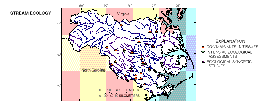
Contaminants in tissues
|
Determine occurrence and distribution of contaminants that can accumulate in tissues of aquatic organisms.
|
Collect and analyze Asiatic clams (Corbicula fluminea) and redbreast sunfish (Lepomis auritus) for trace elements and organochlorine compounds.
|
19
|
1
(in 1992)
|
|
Intensive ecological assessments
|
Assess in detail biological communities and habitat representing selected environmental settings.
|
Sample and quantify fish, macroinvertebrates, and algae at a subset of the water chemistry basic sites; quantitatively describe stream habitat for these organisms; replicate sampling over three stream reaches at four sites.
|
7
|
1-2 in 3-year period
|
|
Ecological synoptic studies
|
Determine presence and community structure of aquatic species and habitat in representative streams across the basin.
|
Sample and quantify fish and(or) macroinvertebrates and(or) algae, and describe habitat at selected water-chemistry sites in the Coastal Plain.
|
46
|
1-2 in 3-year period
|
|
Ground-Water Chemistry
|
|
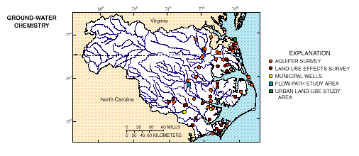
Aquifer survey
|
Describe the overall water quality and natural chemical patterns in aquifers.
|
Sample wells within the shallow aquifers of the Coastal Plain for major ions, nutrients, pesticides, volatile organic compounds, trace elements, and radionuclides; six deep municipal wells sampled in areas of significant drawdown.
|
35
|
1
|
|
Land-use effects
|
Determine the effects of specific land use on the quality of shallow ground water.
|
Sample shallow wells in corn and soybean areas for major ions, nutrients, pesticides, and volatile organic compounds, (some wells sampled only for nitrate, atrazine, and related compounds). Sample wells in urban area, Virginia Beach, Va., for major ions, nutrients, pesticides, and volatile organic compounds.
|
52
|
1
|
|
Flow-path study
|
Describe land-use effects on surficial aquifers along ground-water flow from areas of recharge beneath the land use to discharge to a stream.
|
Sample clusters of wells installed along an approximate line of ground-water flow and at various depths within the surficial aquifers for land-use effects of corn and soybean cultivation; analyze for major ions, nutrients, and pesticides; volatile organic compounds and age-dating constituents analyzed once at some wells.
|
27
|
~4 per year
|
 (10,644 bytes)