![]()
Different study designs were used for collecting data associated with stream chemistry and ecology and ground-water chemistry. For streams, sites were selected to represent specific environmental settings (combinations of physiography, land use, and stream size). Ground-water networks and sites can be described in terms of their environmental setting (characteristics of hydrogeology and land use). Physiography, land use, stream size, and hydrogeology are all factors that should be considered because of their effects on water quality.
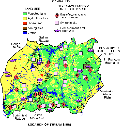
To the extent practical, stream sites represent areas of relatively homogeneous physiography and land use. Sampling sites were first classified by physiographic area, then by predominant land use and basin size.
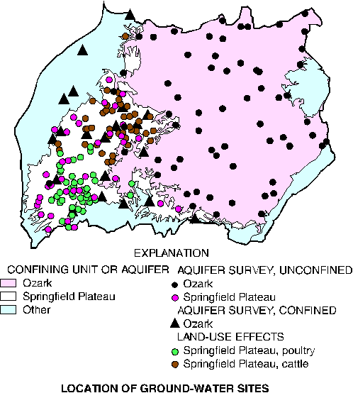
Springs and wells in the Springfield Plateau aquifer and unconfined part of the Ozark aquifer were randomly selected for sampling as part of the unconfined aquifer survey. Several public-supply wells in the confined part of the Ozark aquifer also were selected for sampling. To aid study of the effects of land use and hydrogeology on ground-water chemistry, springs and wells were randomly selected in a poultry-production area and a cattle-production area of the Springfield Plateau. Land-use and hydrogeologic information was used to characterize springs and wells after they were selected and sampled.
An emphasis of the NAWQA design is the use of multiple lines of evidence to describe water-quality conditions (Gilliom and others, 1995). Thus, data have been collected for chemistry of streams and ground water, bed sediment, and biological tissue (tissue from clams and fish); stream ecological conditions; and environmental factors such as land-use percentages and human population. The sampling sites associated with the various study components are shown on the appropriate maps, and the designs of the individual study components are described in the table on the following page.
|
Location of ground-water sites |
Location of stream sites |
[Contaminants in bed sediment and aquatic biota also sampled at all of these sites]
| Site number (see figure above right) |
Site name | Site number (see figure above right) |
Site name |
|---|---|---|---|
| 1 | Buffalo River near Boxley, Ark. | 8 | Yocum Creek near Oak Grove, Ark. |
| 2 | North Sylamore Creek near Fifty-Six, Ark. | 9 | Dousinbury Creek near Wall Street, Mo. |
| 3 | Paddy Creek above Slabtown Spring, Mo. | 10 | Elk River near Tiff City, Mo. |
| 4 | Buffalo River near St. Joe, Ark. | 11 | Illinois River near Tahlequah, Okla. |
| 5 | Black River near Lesterville, Mo. | 12 | Niangua River at Windyville, Mo. |
| 6 | Jacks Fork River at Alley Spring, Mo. | 13 | Kings River near Berryville, Ark. |
| 7 | Current River at Van Buren, Mo. | 14 | Center Creek near Smithfield, Mo. |
| Study component | What data were collected and why | Types of sites sampled | Number of sites |
Sampling frequency and period |
|---|---|---|---|---|
| Stream Chemistry | ||||
| Basic sites-general water chemistry | Continuous streamflow, nutrients, major ions, trace metals, bacteria, organic carbon, suspended sediment, and physical parameters to describe concentrations and seasonal variations. | Streams draining predominant land-use types across Study Unit: forested, agriculture, mining, and urban. | 14 | Monthly plus storms Apr. 1993-Sept. 1995 (one site activated Jan. 1995) |
| Intensive sites-pesticides, nutrients, bacteria | In addition to the above constituents, 82 dissolved pesticides to determine concentrations and seasonal variations. | Subset of basic sites draining agricultural land-use areas. | 2 | Weekly to monthly Feb. 1994-Jan. 1995 |
| Synoptic sites-water chemistry | Streamflow, nutrients, major ions, trace metals, pesticides, bacteria, organic carbon, suspended sediment, and physical parameters during high or low flow conditions to describe concentration and spatial distribution. | Streams draining forested, agricultural, and urban land-use areas. | 29 | Three in 1994-95 |
| Contaminants in bed sediments | Trace elements and hydrophobic organic compounds to determine occurrence and spatial distribution. | Depositional zones for all basic and intensive sites and many synoptic sites. | 27 | Once in 1992-95 |
| Contaminants in aquatic biota | Trace elements in clams (soft tissue) and fish livers and organic compounds in clams (soft tissue) and whole fishes to determine occurrence and spatial distribution. | All basic and intensive sites and some synoptic sites. Samples were taken from fish and clam species generally common across the Study Unit. | 25 | Once in 1992-95 |
| Stream Ecology | ||||
| Intensive assessments | Fish, macroinvertebrates, algae, and aquatic and riparian habitat to assess biological communities in different land uses. | Stream reaches were collocated with basic and intensive sites. Sites represent the variety of land uses within the Study Unit. | 14 | Once annually in 1993-95; three reaches sampled at each of three sites one year |
| Synoptic assessments | Similar to intensive assessments, except only one reach per site and fish were sampled at only four sites, for areal comparison of habitat and community composition. | Stream reaches were collocated with a subset of synoptic stream chemistry sites. | 27 | Once in 1994 |
| Ground-Water Chemistry | ||||
| Aquifer survey-bedrock, unconfined | Nutrients, major ions, trace elements, pesticides, volatile organic compounds (wells), and radionuclides to determine overall water quality and natural chemical patterns in unconfined parts of Springfield Plateau and Ozark aquifers. | Domestic wells (49) and springs (50). | 99 | Once in 1993 |
| Aquifer survey-bedrock, confined | Nutrients, major ions, trace elements, pesticides, volatile organic compounds, and radionuclides to determine overall water quality and natural chemical patterns in the confined part of the Ozark aquifer. | Public supply wells located in northwestern Arkansas, southeastern Kansas, southwestern Missouri, and northeastern Oklahoma. | 20 | Once in 1993-94 |
| Land-use effects-agricultural | Nutrients, major ions, pesticides, and radionuclides to determine the effect of agricultural practices (poultry and cattle) on the quality of ground water in the Springfield Plateau aquifer. | Domestic wells (20) and springs (22) for a study that focused on land used for confined poultry; domestic wells (20) and springs (20) for a study that focused on land used for raising cattle. | 82 | Once in 1994-95 |
| Special Studies | ||||
| Black River trace element study-water, bed-sediment, and tissue chemistry; stream ecology | Similar to data collected for the study components for stream chemistry: basic sites, contaminants in bed sediment, and contaminants in fish tissue; and for stream ecology: synoptic assessments. The data were collected to describe effects of lead-zinc mining on water quality, bed sediment, aquatic biota, and biological communities. | Streams, depositional zones, and stream reaches located within an area of lead-zinc mining. | 10 | Once in 1995 |
| Small-basin study (not shown on map) | Nutrients, major ions, and pesticides to describe, on a local scale, occurrence and distribution in a small Springfield Plateau basin. | Domestic (18) and monitoring (11) wells, springs (4), and streams (3) within the Flint Creek Basin. | 36 | Once in 1995 |
Suggested citation:
Petersen, J.C., Adamski, J.C., Bell, Davis, J.V., Femmer, S.R., Freiwald,
D.A., and Joseph, R.L., 1998, U.S. Geological Survey Circular 1158, on
line at < URL: https://water.usgs.gov/pubs/circ1158>, updated
April 3, 1998
This page is a subpage of <URL:http://water.usgs.gov/pubs/circ1158>
Email questions and comments to GS-W_NAWQA_Outreach@usgs.gov
Last modified: 4/3/98