![]()
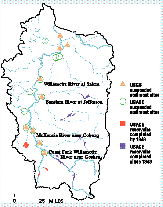
Eleven multipurpose and two re-regulation reservoirs (1.88 million acre-feet of usable storage) are operated in the Willamette Basin by the U.S. Army Corps of Engineers (USACE) (Shearman, 1976). Measurements of suspended sediment in streams downstream from dam sites indicate that sediment sources have changed since completion of 10 reservoirs after 1949.
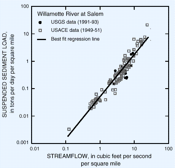
Measurements of suspended sediment in Willamette Basin streams suggest that erosion has increased downstream from dams since their construction. |
Reservoirs intercept sediment and may be expected to change the downstream relationship between suspended sediment load and stream discharge. However, data for Willamette Basin streams indicate that the relationships are similar for pre- and post-reservoir periods. This suggests that erosion has increased downstream from dams since their construction. Possible sources of sediment downstream from dams include channel erosion and erosion of land developed after dam construction.
The graph for the Willamette River at Salem is typical of relationships between suspended sediment load and streamflow for the 14 USGS and/or USACE sites shown on the map (Laenen, 1995). These relationships indicate that annual suspended sediment loads for Willamette Valley tributaries are about twice those for Coastal tributaries and nearly four times those for Cascade tributaries.
At the four sites labeled on the map, data were sufficient to determine that relationships between suspended sediment load and stream discharge downstream from USACE dams were not different during pre- and post-reservoir periods. This is demonstrated by the clustering of 1991-93 data within the area of the graph outlined by the 1949-51 data. The similarity of sediment transport during pre- and post-reservoir periods suggests that the amount of sediment trapped by the reservoirs has been balanced by increased erosion of downstream sediment sources.
Decreased particle size of suspended sediment downstream from dams since their construction provides further evidence that sediment sources have changed. Particle sizes of suspended sediment for post-reservoir samples were finer than for pre-reservoir samples at some sites (Laenen, 1995). For example, the pre-reservoir average was 65 percent clay and silt for the Willamette River at Salem, whereas the post-reservoir average was 82 percent. For the Santiam River at Jefferson, the pre-reservoir average was 45 percent clay and silt, and the post-reservoir average was 68 percent. The smaller particle size measured since dam construction suggests that a new source is contributing the sediment now being measured downstream from the dams.
Decreased particle size may be important because nutrients, such as phosphorus, and toxic constituents, such as dioxins and furans, chlorinated pesticides, and trace elements, can be transported in association with fine sediment.
Stream discharge, suspended sediment concentrations, and percentages of clay and silt were determined for seven streamflow gaging stations during 1991-93 (Laenen, 1995). Similar data from two additional gaging stations were collected as part of the USGS National Stream Quality Accounting Network. These data were compared to published information available for 11 stream sites (U.S. Army Corps of Engineers, 1954) to evaluate possible changes in sediment transport downstream from USACE reservoirs completed since 1949.