![]()
Radon is present in ground water throughout the Potomac River Basin. The Federal drinking-water standard for radon is currently under review by the U.S. Environmental Protection Agency; however, radon levels in 69 percent of ground-water samples were greater than a previously proposed standard of 300 picocuries per liter. Of 104 ground-water samples, 103 contained detectable levels of radon and levels ranged from among the lowest to among the highest in the Nation.
A colorless, odorless, radioactive gas, radon forms naturally in rocks and soils through the radioactive decay of radium, a product of uranium decay. Radon commonly enters buildings through foundation cracks and may dissolve in ground water and be carried into buildings served by water supply wells. Radon from ground water is released into household air when water is used for showering, washing, and other everyday purposes. According to the U.S. Surgeon General, exposure to airborne radon is second only to cigarette smoking as a cause of lung cancer. The risk of cancer increases with exposure to increasing levels of airborne radon (U.S. Environmental Protection Agency, 1994b).
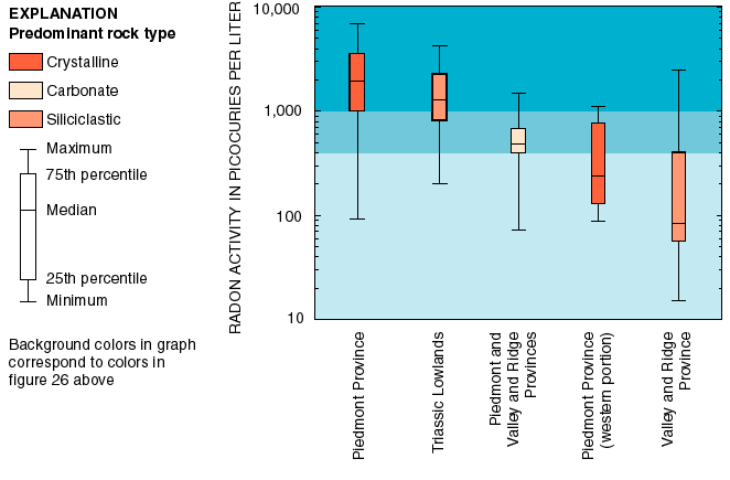
Radon activities in ground water of the Potomac River Basin are related to rock type. Ground-water radon activities are highly variable in all areas but are typically higher in areas underlain by crystalline rocks of the Piedmont than in areas underlain by carbonate rocks (figs. 26, 27). (Amounts of radioactive elements (such as radon) are often reported in terms of activities rather than concentrations.) Crystalline rocks of predominantly granitic composition, like many of those in the Piedmont, contain more uranium, on average, than do carbonate rocks (Faure, 1986). The part of the Piedmont west of the Triassic Lowlands is an exception; ground-water radon activities in this area are typically lower than in carbonate areas. This area contains some granitic rocks, but many of the crystalline rocks of this area are not predominantly granitic like those of the rest of the Piedmont. Rocks of this type contain much less uranium, on average, than do granitic or carbonate rocks (Faure, 1986).
Ground-water radon activities in the Triassic Lowlands are among the highest detected in the basin. The rocks of the Triassic Lowlands are mainly siliciclastic and extend south from the area of Gettysburg, Pa., to the west of Washington, D.C., through Maryland and Virginia. Ground-water samples from these rocks contained radon activities comparable to those measured in samples from the primarily granitic rocks of the Piedmont (figs. 26, 27).
Ground-water radon activities in the Valley and Ridge are generally very low. The Valley and Ridge covers most of the basin from the area of western Maryland through eastern West Virginia and is underlain primarily by siliciclastic rocks. Unlike samples from the siliciclastic rocks of the Triassic Lowlands, however, samples from these rocks typically contained very little radon (figs. 26, 27).