USGS

Water Quality in the Potomac River Basin, Maryland, Pennsylvania, Virginia, West Virginia, and the District of Columbia, 1992-96

Table of contents || Previous section || Next section || Glossary


WATER-QUALITY CONDITIONS IN A NATIONAL CONTEXT

|| Surface water || Ground water ||

Comparison of Ground-Water Quality in the Potomac River Basin with Nationwide NAWQA Findings

Map of 20 NAWQA study units sampled during 1992-95 (5,387 bytes)

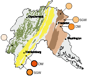
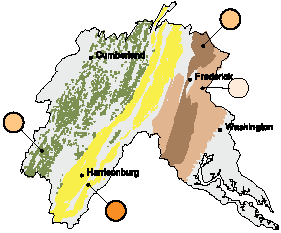
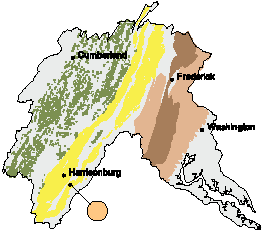
Five major water-quality characteristics were evaluated for ground-water studies in each NAWQA Study Unit. Ground-water resources were divided into two categories:
(1) drinking-water aquifers, and (2) shallow ground water underlying agricultural or urban areas. Summary scores were computed for each characteristic for all aquifers and shallow ground-water areas that had adequate data. Scores for each aquifer and shallow ground-water area in the Potomac River Basin were compared with scores for all aquifers and shallow ground-water areas sampled in the 20 NAWQA Study Units during 1992-95. Results are summarized by percentiles; higher percentile values generally indicate poorer quality compared with other NAWQA ground-water studies. Water-quality conditions for each drinking-water aquifer also are compared to established drinking-water standards and criteria for protection of human health. (Methods used to compute rankings and evaluate standards and criteria are described by Gilliom and others, in press.)

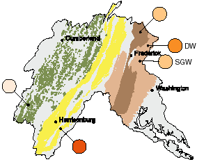
EXPLANATION

Shallow drinking-water aquifers

Great Valley Carbonate, ag. areas; Valley and Ridge, ag. areas; Piedmont; Triassic Lowlands

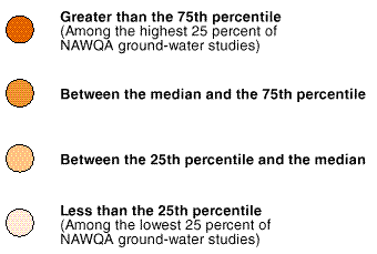
Ranking of ground-water quality relative to all NAWQA ground-water studies--

DW indicates ranking compared to drinking-water aquifers (only), nationwide

SGW indicates ranking compared to shallow ground-water (only), nationwide

No label indicates comparison to DW and SGW

Darker colored circles generally indicate poorer quality. Bold outline of circle indicates one or more standards or criteria were exceeded.

Explanation of percentiles and colors


RADON

Map:Radon (6,117 bytes)
 

The occurrence of radon in ground water is dependent on a number of geologic and hydrologic factors, especially bedrock composition. Ground-water radon levels in the crystalline and siliciclastic rocks of the Piedmont and Triassic Lowlands in the eastern part of the basin are among the highest observed nationwide. Radon activities in carbonate rocks of the Great Valley are also relatively high, but activities in the western part of the Valley and Ridge are among the lowest in the Nation.

NITRATE

Map:Nitrate (6,588 bytes)
 

Nitrate concentrations in ground water in carbonate rocks underlying agricultural areas of the basin are among the highest in the Nation; nearly 25 percent of samples contained nitrate at concentrations exceeding the Federal drinking-water standard. Nitrate concentrations in the Piedmont area of the basin are also relatively high compared to other drinking-water sources across the Nation, although no samples exceeded the drinking-water standard. Nitrate concentrations in the Triassic Lowlands and under agricultural lands in the Valley and Ridge are relatively low.

DISSOLVED SOLIDS

Map:Dissolved Solids (5,680 bytes)
 

Concentrations of dissolved solids in ground water in carbonate aquifers underlying agricultural areas of the basin are among the highest in the Nation; 10 percent of samples exceeded the Federal drinking-water standard. Dissolved solids concentrations in other sampled areas of the Potomac River Basin are generally lower, although the drinking-water standard was exceeded in 14 percent of the samples from the Triassic Lowlands and 4 percent from the Valley and Ridge.

VOLATILE ORGANIC COMPOUNDS

Map:Volatile Organic Compounds (5,254 bytes)
 

Concentrations of volatile organic compounds (VOCs) in agricultural areas of the Great Valley are among the lowest in the Nation. Only 6 percent of the samples contained detectable VOCs, and no Federal drinking-water standards were exceeded. No other area of the Potomac River Basin was sampled for VOCs as part of the NAWQA Program.

PESTICIDES

Map:Pesticides (6,148 bytes)
 

Pesticide concentrations in agricultural areas of the Great Valley Carbonate are among the highest in the Nation; 85 percent of samples contained detectable pesticides. Ground water in the Piedmont also contains relatively high levels of pesticides. By contrast, pesticides were detected in only 12 percent of wells in agricultural areas of the Valley and Ridge.

CONCLUSIONS

In general, the presence of pesticides, nitrate, and dissolved solids in ground water is related to agricultural land use--particularly in areas underlain by carbonate rocks. Potential urban sources of nitrate, pesticides, and VOCs were not investigated.

Radon occurrence in ground water is related to rock type. Igneous and metamorphic rocks of granitic composition (and sedimentary rocks derived from granitic rocks) tend to contain more uranium (Faure, 1986) and, therefore, higher activities of radon than rocks of other types. Uranium is often concentrated in carbonate rocks as well.


U.S. Geological Survey Circular 1166

Table of contents || Previous section || Next section || Glossary

Suggested citation:
Ator, S.W., Blomquist, J.D., Brakebill, J.W., Denis, J.M., Ferrari, M.J., Miller, C.V., and Zappia, H., 1998, Water Quality in the Potomac River Basin, Maryland, Pennsylvania, Virginia, West Virginia, and the District of Columbia, 1992-96: U.S. Geological Survey Circular 1166, on line at <URL: https://water.usgs.gov/pubs/circ1166>, updated June 10, 1998 .

This page is a subpage of <URL:http://water.usgs.gov/pubs/circ1166>
Email questions and comments to GS-W_NAWQA_Outreach@usgs.gov
Last modified: Wed Jun 24 17:13:08 1998