![]()
The goal of the data collection for this study was to characterize, in a nationally consistent manner, the broad-scale geographic and seasonal distribution of water-quality conditions in relation to major contaminant sources and background conditions (Gilliom and others, 1995). The study design was multidisciplinary in nature, examining the stream chemistry, stream ecology, and ground-water chemistry across the basin. To the extent possible, sampling sites represent homogeneous combinations of land use, ecoregions, and hydrogeology that generally are relevant to surface- and ground-water quality. An environmental framework of the basin was developed and a stratification process followed in which sampling sites were selected that address the most important water-quality issues and concerns within the basin. Physiographic province, ecoregion, geology, and land use were the strata used in the site selection process.
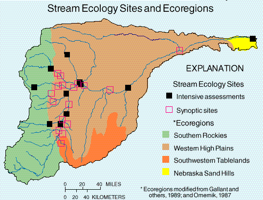
Stream Ecology Sites and Ecoregions
 (24,470 bytes)
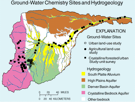
One of the advantages of the NAWQA design is the use of multiplelines of evidence to describe water-quality conditions (Gilliom and others, 1995). The multiyear (April 1993-September 1995), intensive data collection phase of the South Platte River Basin study provided information on stream chemistry, chemistry of bed sediment and fish tissue, stream ecology, and ground-water chemistry. The sampling sites associated with the various study components are plotted on the appropriate maps, and the designs of the individual study components are described in the table on the following page.
Finally, study design and data collection activities during the intensive multiyear sampling effort yielded 104 surface-water sites on 24 streams, 35 sampling locations in 5 reservoirs, and 159 wells throughout the basin.
Ground-Water Chemistry Sites and Hydrogeology
 (34,685 bytes) (34,685 bytes)
|
|
Study |
What data where collected and why |
Types of data sampled |
Number |
Sampling |
|---|---|---|---|---|
|
STREAM CHEMISTRY |
||||
|
Basic Fixed Sites |
Continuous streamflow, major ions, nutrients, organic carbon, suspended sediment, and physical parameters: Describe concentration, seasonal variability, and loads. |
Streams draining predominant land-use types across basin: forest, urban, mixed, agriculture, and rangeland. |
12 |
Monthly plus storm; |
|
Intensive Fixed Sites |
In addition to the above constituents, 83 dissolved pesticides were analyzed to determine concentration and timing of occurrence. |
A subset of basic sites draining agricultural and urban land-use areas. |
3 |
Minimum monthly plus |
|
Synoptic sites- |
Streamflow, nutrients or pesticides, and physical parameters were determined during high or low flow conditions to describe short-term presence and distribution of constituents over broad scale in basin. |
Streams draining a variety of land-use types; 5 synoptics for nutrients and 3 synoptics for pesticides. |
20-64 |
April,May,June,Aug., |
|
Contaminants - |
Trace elements and hydrophobic pesticides and other organic compounds were analyzed in streambed sediments to determine occurrence and spatial distribution. |
Depositional zones for all basic and intensive sites and several synoptic sites. |
23 |
Summer 1992 (17) and |
|
Contaminants - |
Trace elements in fish livers and organic compounds in composites of whole fish were sampled and analyzed to determine occurrence and spatial distribution. |
All basic and intensive sites and some synoptic sites. Samples were taken from fish species common to and across Study Unit. |
23; |
Summer 1992 (17) and |
|
Stream Ecology |
||||
|
Intensive assess- |
Fish, macroinvertebrates, algae, and aquatic and riparian habitat were sampled and described to assess biological communities in different land uses. |
Stream reaches were co-located with basic sites. Sites represent the variety of land uses within the basin. |
11 |
Once in 1993-95; 3 |
|
Synoptic sites |
Macroinvertebrates, algae, nutrients, and aquatic and riparian habitat were sampled to assess spatial distribution of biological communities in predominant land uses. |
Stream reaches were co-located with basic sites and a sub-set of synoptic stream chemistry sites. Sites represent urban, agricultural, and mixed land uses. |
26 |
Once in summer 1993 |
|
Ground-Water Chemistry |
||||
|
Land-use effects |
Major ions, nutrients, pesticides, VOCs, radon, trace elements, and DOC were sampled and analyzed to determine effects of Denver metro area on the quality of recently recharged ground water in the alluvial aquifer. |
Existing non-drinking water wells screened near the water table in the urban area were located using a statistically random selection process. |
30 |
Once in 1993 (July-Sept.) |
|
Land-use effects |
Major ions, nutrients, pesticides, VOCs, radon, trace elements, tritium, DOC, and isotopes of nitrogen and uranium were sampled and analyzed to determine effects of irrigated agriculture on the quality of recently recharged ground water in the alluvial aquifer. |
Newly installed monitoring wells completed at water table were located using a statistically random selection process. Predominant crops: Corn, wheat and grains >20 percent. |
30 |
Once in 1994 (June-Aug.) |
|
Aquifer Study- |
Major ions, nutrients, pesticides, VOCs, radon, trace elements, trituim, and DOC were sampled and analyzed to assess condition of ground-water quality in forested urbanized crystalline bedrock aquifer. |
Existing domestic wells completed in bedrock (<400 ft deep) located using a statistically random selection process. |
27 |
Once in 1995 (July-Sept.) |
|
Special Studies |
||||
|
Reservoir sites- |
Nutrients and physical parameters were determined from vertical profiles in agricultural reservoirs during one reservoir irrigation season. Nutrient budgets computed to determine if reservoirs are a source/sink of nutrients to irrigation supply water. Sampled for algae and chlorophyll. |
Five reservoirs (Riverside, Jackson, Jumbo, Prewitt, and Sterling) were selected in agricultural land-use areas. |
37 (7 |
March,June,July,Sept., |
|
Stream-aquifer |
Major ions, nutrients, dissolved gases, stable isotopes of carbon, nitrogen, and sulfur, chlorofluorocarbons, tritium, and DOC were collected and analyzed to describe the processes controlling the fate of nitrogen-contaminated ground water near areas of discharge to the South Platte River. |
Monitoring wells were installed along flow paths from recharge to discharge area. Wells were nested and sampled top, middle, and bottom of aquifer. |
47 |
1 round of sampling |
|
Degradation |
Major ions, nutrients, dissolved gases, VOCs, stable isotopes of carbon, and DOC were collected and analyzed to determine the transport and degradation of VOCs in the alluvial aquifer. |
Monitoring wells were installed and sampled along flow paths from a known VOC contaminant source to its discharge to South platte River. Wells were nested and completed at mutliple depths. |
25 |
2 rounds in 1994; 1 round |
