![]()
Water development in the South Platte River Basin began in 1870 when the first irrigation ditches were dug in the vicinity of Greeley, Colo. Today, hundreds of structures withdraw more than 3 million acre-feet of water from streams each year, dozens of water storage reservoirs store more than 2 million acre-feet of water each year, 12 transmountain diversions import 400,000 acre-feet of water into the basin each year, and several thousand wells pump an estimated 1 million acre-feet of water each year (Dennehy and others, 1993).
These alterations of the natural hydrologic system have affected the quantity and quality of water in the South Platte River. For example, at several locations along the river, there exist "dry points"--locations where water diversions remove all the water from the river. Withdrawals of water for urban and agricultural use have resulted in less water available to dilute contaminants in the river. The existence of dry points (lack of streamflow) upstream from wastewater-treatment plant discharges has led to nutrient concentrations in the South Platte River that are substantially higher than elsewhere in the Nation (Litke, 1996).
Alterations of the natural hydrologic system also have resulted in less water in the river during spring snowmelt runoff and more water in the river during fall and winter. Historically, the South Platte River ran dry in the plains when the supply of mountain snowmelt was exhausted. Now, seepage of irrigation water from ditches and fields replenishes the alluvial aquifer during spring and summer, and the aquifer slowly drains during fall and winter by discharging ground water to the South Platte River. This altered flow regime has changed native aquatic habitat along the river. For example, because scouring high flows are less common, vegetation along the channel has increased (Knopf, 1991), and the active channel is narrower than in the past.
Ground water contributes substantially to streamflow in the South Platte River in the plains (Litke, 1996). As a result, nitrate, dissolved solids, and the pesticides atrazine and prometon, which can be mobilized in irrigation water as it infiltrates from agricultural fields into ground water, are subsequently transported into streams (Litke, 1996; Bruce and McMahon, 1998; Kimbrough and Litke, in press). Improvements in water quality, therefore, depend on management of agricultural nonpoint sources, which are a long-term concern because ground water and its associated dissolved chemical constituents can take as long as 25 years to migrate from beneath fields to the river (McMahon, 1995).
 (37,282 bytes)
The Burlington Canal can remove all the flow from the South Platte River near Denver, Colo.
 (11,564 bytes)
Alteration of natural streamflow for development has resulted in a substantial decrease in channel width along the South Platte River from 1865 to the present. Most of the change occurred prior to 1938.
 (20,146 bytes)
The importance of ground-water discharge to the South Platte River is shown in the river water balance during April 1994. Large amounts of water withdrawn from the river for irrigation are replaced by large amounts of ground-water discharge into the river.
Because surface water was withdrawn all along the river and was replaced by ground water, there was a recycling effect on the water as it moved downstream. This reuse resulted in increasing salinity in a downstream direction in shallow alluvial ground water (Bruce and McMahon, 1998) and in surface water (Litke and Kimbrough, 1998). Salinity increases are related to water reuse and are caused by evaporation, dissolving soil minerals, and the concentration of salts in the soil zone as plants utilize soil water. Deterioration of the quality of the water resource from increased salinity can affect its suitability for irrigation and as a drinking-water supply.
 (16,881 bytes)
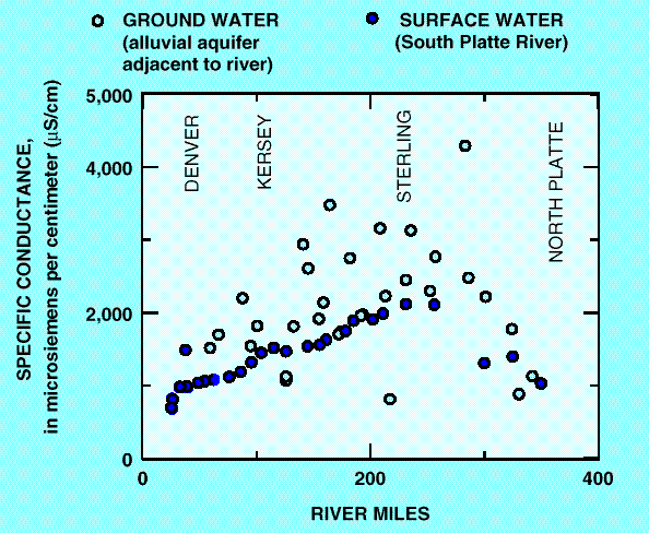
Specific conductance (a measure of salinity) in ground water from the alluvial aquifer adjacent to the South Platte River and in surface water from the South Platte River indicates that salinity increases from Denver to Sterling, Colo., as water is reused. Salinity then decreases near the mouth of the basin, probably due to dilution by discharge of higher quality ground water from the Ogallala aquifer.
 (16,982 bytes)
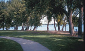
Recreational land developed along an agricultural reservoir in Loveland, Colo., shows that use of water resources can be shared.
Offstream reservoirs are an important part of the water development infrastructure. About 30 percent of the streamflow in the South Platte River at Kersey, Colo., is stored in offstream reservoirs during fall and winter for use the following irrigation season. Total nitrogen concentrations, more specifically nitrate, decreased in reservoir water during summer (R. Kimbrough, U.S. Geological Survey, written commun., 1997), most likely due to biological uptake. The practice of storing streamflows in agricultural reservoirs could reduce nitrate concentrations before flows are released for irrigation in summer. Expanded use of this management strategy could reduce nitrate levels throughout the basin.
 (14,807 bytes)
Nitrate concentrations in water from an agricultural reservoir during monthly sampling in 1994 decreased steadily during the summer, most likely due to biological uptake.
Water development has led to the extensive use and reuse of water in the South Platte River Basin, and urban and agricultural water development have contributed to some degradation of water quality. However, the exsistence of the water-development infrastructure allows for the possiblity of improvement of water quality by careful management. |