![]()
Table of contents || Previous section || Next section || Glossary || PDF document
 (11,795 bytes)
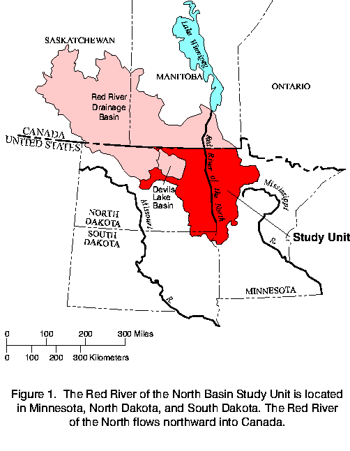
Figure 1. The Red River of the North Basin Study Unit is located in Minnesota, North Dakota, and South Dakota. The Red River of the North flows northward into Canada.
To assess the water quality in the basin, the Study Unit was divided into four subregions (fig. 2) that represent reasonably homogeneous environmental conditions of climate, topography, geology, soils, and land use and land cover. These environmental conditions can affect the amounts and concentrations of chemicals, sediment, and biota in water.
Figure 2. The major land use in the Red River of the North Basin Study Unit is agriculture.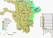 (12,673 bytes)
Knowledge of land-use type and location is important because pesticides and nutrients applied to the soil and crops can leach into ground water or enter streams through runoff. About 81 percent of the land area in the Study Unit is agricultural, and 64 percent of the total area is cropland (fig. 2). Principal crops are wheat, barley, corn, and soybeans. Secondary crops include oats, sugar beets, sunflowers, potatoes, and forage grasses. Most nonagricultural land is along the eastern edge of the Study Unit.
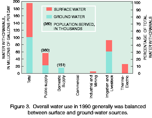
Good quality water is important for residents in the Study Unit. In 1990, about 36 percent of the withdrawals from surface water in the basin were used for public supply (Stoner and others, 1993). Most of these withdrawals were from the Red River by Fargo and Grand Forks, North Dakota, and Moorhead, Minnesota, the major urban areas in the basin. Public supplies also came from ground water. In rural areas, water for domestic use was obtained almost exclusively from glacial sand and gravel aquifers. All public drinking water should meet standards to protect the health of the population and preferably have no objectionable taste or odor. Water use also can affect water quality. For example, irrigation, accounting for 47 percent of all 1990 water withdrawals (fig. 3), can increase leaching of salts and agricultural chemicals into shallow ground water.
 (8,673 bytes)
Figure 3. Overall water use in 1990 generally was balanced between surface and ground-water sources.
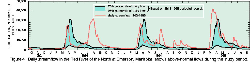
Streamflow generally was above average during the 1993-95 period of sampling. The spring peaks for 1993 and 1994 were generally within the 25th and 75th percentile of flow (fig. 4), and the peak for 1995 was above the 75th percentile of flow. Summer storms produced streamflows much larger than the 75th percentile in each of the sampling years, with the storms of 1993 resulting in very large flow. Large summer rainfalls can remove nutrients and pesticides applied after the spring snowmelt and result in larger than normal concentrations and loads of these constituents in streams. Spring peak flows can contain pesticides applied in the fall and nutrients leached from decaying matter and soils.
 (12,492 bytes)
Figure 4. Daily streamflow in the Red River of the North at Emerson, Manitoba, shows above-normal flows during the study period.
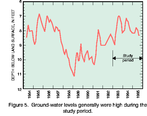
Ground-water levels generally were high during the 1993-95 period of sampling. Drought conditions that lasted from 1987 into 1991 preceded this sampling. Ground-water levels generally rose from the end of the drought to the time of sampling as a result of increased recharge. This rise can be seen in the hydrograph for a well located in the southeast subregion (fig. 5). Recharge can affect the quality of shallow ground water. The quality of shallow ground water is affected by land-use activities and relatively recent (0-10 years) recharge. However, the quality of deeper ground water, which typically is older than 20 years, is less affected by relatively recent land-use activities and recharge.
 (7,297 bytes)
Figure 5. Ground-water levels generally were high during the study period.