MAJOR ISSUES AND FINDINGS
(E) Sediment in Streams
``The presence of sediment is one of the most obvious characteristics of small
streams. Sediment has several forms and sources, but of greatest concern in
stream and river sediment problems are the fine inorganic particles that
either flow with the current (causing turbidity) or that are deposited on the
streambed (causing loss of benthic productivity and fish habitat). Such
sediment is widespread and pervasive, occurring to some extent in all
streams.''--Thomas F. Waters (1995)
``Obvious effects of ... anthropogenic erosion and sediment deposition include
loss of agricultural soils, decreased water-retention capacity of forest
lands, increased flood frequency, and rapid filling of reservoirs. Less
obvious, however (and until recently largely ignored), is sedimentation in
small streams that affects biotic communities, reduces diversity of fish and
other animal communities, and lowers the productivity of aquatic
populations.'' --Thomas F. Waters (1995)
Reprinted from ``Sediment in streams--Sources, biological effects, and control'' and published with permission.
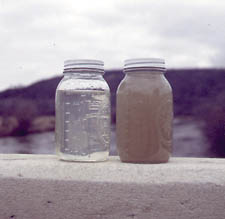
Water with about 10 milligrams per liter suspended sediment (left) is much clearer than water with about 500 milligrams per liter (right) (photograph by Lan Tornes, USGS).
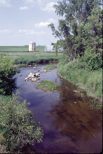
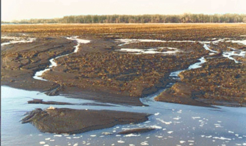
The upper reaches of the Wild Rice River is typical of many streams in the eastern part of the Red River Basin.
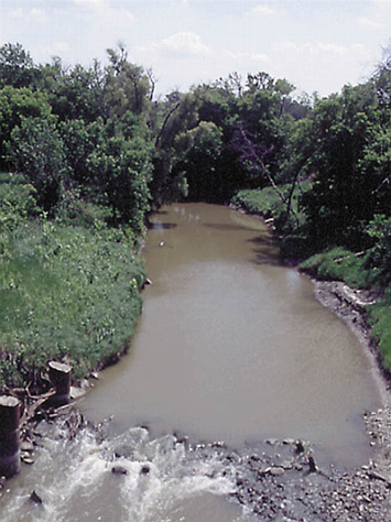
As the Wild Rice River flows downstream (shown near the confluence with the Red River), it becomes visually more turbid. Both photographs were taken in June 1992.
Water in the Red River is turbid, resulting from the fine suspended sediments
(clay and silt). Suspended-sediment concentrations vary greatly in streams in the
Study Unit due to factors such as landscape characteristics, streamflow,
season, and land use. High suspended-sediment concentrations characterize
streams that flow through heavily cropped, erodible lands (especially in the
central part of the Study Unit) and erodible stream channels (especially the
Pembina River). In contrast, low sediment concentrations characterize most
streams that drain upland areas of the Study Unit. Most of these streams flow
through reservoirs, lakes, and wetlands. Suspended sediments settle in these quiescent waters.
Suspended sediment in streams affects the chemical water quality. At high
sediment concentrations, a significant portion of phosphorus and nitrogen in streams is attached
to sediment. Organochlorines such as DDT and PCBs, and trace elements
such as mercury and lead, adhere tightly to sediments, which can settle to the
bottom of streams, lakes, and reservoirs. Organochlorines and trace elements
were found in bed
sediments during this study (Brigham and others, 1998) (see also tables 8 and 9, p. 27-29).
High sediment concentrations also diminish the esthetic water quality. The enjoyment of recreational activities such as fishing, swimming, and boating can be affected by sediment in the stream.
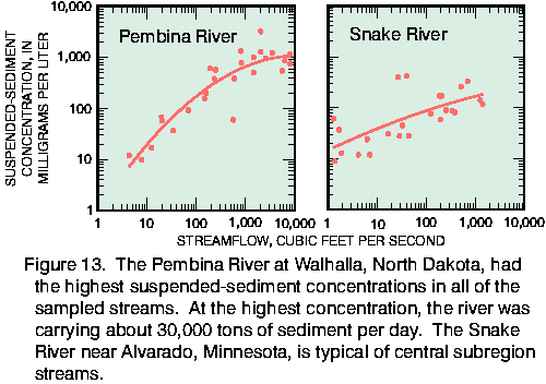
The highest sediment concentrations in each stream typically accompanied high flows (fig. 13). Therefore, sediment concentrations in streams are highest in the spring or after heavy summer rains.

The Otter Tail River flows through numerous lakes and reservoirs. Partly as a result of sedimentation in these quiescent water bodies, the river has low suspended- sediment concentrations.
Land-use practices that do not abate rapid runoff of water can impair water quality by increasing suspended sediment in streams in two ways.
First, runoff erodes bare soils, which contributes sediment to streams. Second, higher streamflows associated with runoff events will more readily erode sediments from the channel and streambanks. The relative importance of these two sources of sediment is unknown for streams in the Red River Basin Study Unit.
Snowmelt runoff carries eroded sediment from a cultivated field to a drainage ditch (foreground). Sand, which is relatively coarse and heavy, settles at low flow velocities; finer silt and clay particles remain suspended at fairly low velocities. The stubble in this field probably helped lessen sediment erosion.
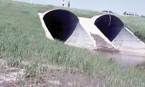
A high-flow event has deposited sediment on the flood plain (foreground) and on the lower part of the concrete structure separating these two culverts on Two Rivers near Northcote, Minnesota.
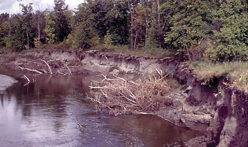
High flows erode the steep banks of the Pembina River, in northeastern
North Dakota, contributing to the high sediment load.