![]()
The NVBR Study Unit (fig. 1), which includes the Las Vegas Valley area in southeastern Nevada and the Carson and Truckee River Basins in northwestern Nevada and northeastern California, is typical of Basin and Range physiography (see Glossary).
| High mountains, exceeding 10,000 ft in some
areas, surround valleys underlain by thick, unconsolidated deposits [1].
Consolidated rocks in high mountains are primarily carbonate rocks in the
Las Vegas Valley area and granitic and volcanic rocks in the Carson and
Truckee River Basins (fig. 2). Unconsolidated deposits beneath valleys
(fig. 2), which range from clay to boulders, are present in thicknesses
as great as 5,000 ft [4].
High mountains are headwater areas that can receive more than 20 inches of annual precipitation (fig. 3). Basin areas are low mountains and valleys that can receive less than 4 inches of annual precipitation (fig. 3). Most of the precipitation falls during the winter (fig. 3). Precipitation in headwater areas provides runoff to recharge principal aquifers [4] and to sustain streamflow. Principal aquifers (fig. 3) are present in unconsolidated deposits beneath some valleys. |
|
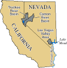
Figure 1. The Nevada Basin and Range Study Unit includes the Las Vegas Valley area and the Carson and Truckee River Basins in Nevada and California. |
|

(click for full size image; 65K) Figure 2. Natural factors (rock types and geothermal activity) and human activities (mining) affect water resources. Geology modified from [2,3]. |
Streamflow in Las Vegas Wash, which drains Las Vegas Valley, is sustained
by urban drainage and discharge of treated sewage from the Las Vegas urban
area. Although mean seasonal streamflow is higher in winter and spring,
seasonal differences are overshadowed by the nearly fourfold increase in
streamflow during October 1964 through September 1995 (water years 1965-95).
This increase in streamflow (fig. 4A) was caused by increasing rates
of urban drainage and discharge of treated sewage [4].
Streamflow in the Carson and Truckee Rivers, which drain the Carson and Truckee River Basins, is primarily due to snowmelt runoff in mountainous headwater areas. Streamflow in the Carson and Truckee Rivers commonly is highest in the spring and lowest in the autumn. Periods of above- and below-average streamflow are shown in the barcharts below the streamflow hydrographs in figure 4B. During the 3-year intensive sampling period for this cycle of the NVBR NAWQA investigation (1993-95), near-average, below-average, and above-average streamflow conditions were measured. Streamflow in the rivers decreases as it flows from headwater areas in the Sierra Nevada to terminal areas. Treated sewage effluent can be a substantial part of flow in the Truckee River downstream from the Reno-Sparks urban area during low-flow conditions. |
| Although range and forest land uses dominate in the Study Unit, urban and agricultural land uses are important in some areas. Land use in Las Vegas Valley (fig. 5) included about 79 percent range, 14 percent forest, and 5 percent urban [4]. Urban land use in Las Vegas Valley is concentrated in the Las Vegas area, which includes Las Vegas and adjacent developed areas. Land use in the Carson River Basin (fig. 5) included about 62 percent range, 18 percent forest, 14 percent open water and wetlands, and 5 percent irrigated agriculture [1]. Agricultural land use in the Carson River Basin was primarily in Carson Valley and Carson Desert (fig. 5). Land use in the Truckee River Basin (fig. 5) included about 53 percent range, 27 percent forest, 12 percent open water and wetlands, 3 percent urban, and 2 percent irrigated agriculture [1]. The primary urban area in the Truckee River Basin is Reno-Sparks. The principal irrigated crops grown in the Study Unit are pasture and alfalfa. | 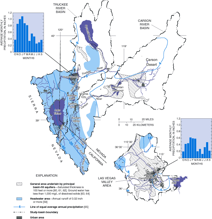
(click for full size image; 64K) Figure 3. Winter precipitation in mountainous headwater areas provides water for streamflow and aquifer recharge. |
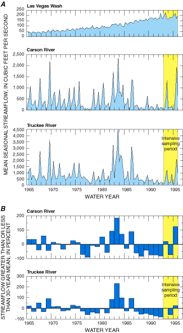
(click for full-size image; 26K) Figure 4. Streamflow during October1964-September 1995 (water years 1965-95) in Las Vegas Wash increased because of urban drainage and discharge of treated sewage (A). Streamflow in the Carson and Truckee Rivers was characterized by periods of above- and below-average streamflow (B). |
Historical mining activities in the Carson River Basin have affected
the quality of streams. The Leviathan Mine (fig. 2) was operated intermittently
from the early 1860s until 1962. About 22 million tons of overburden containing
sulfide minerals were discarded in the mine area [5]. Bryant Creek, a tributary
to the East Fork Carson River (fig. 3), and several of its tributaries
receive acidic drainage and trace metals from the mine. The Comstock Lode,
a silver- and gold-rich ore body, (fig. 2) was intensively mined during
1860-80. During this period, mercury amalgamation was used to recover silver
and gold from bulk ore. An estimated 7,500 tons of elemental mercury were
lost from ore processing, mostly in the Carson River Basin downstream from
Carson City (fig. 3) [6]. The reach of the Carson River downstream from
Carson City currently (1998) is being investigated by other researchers
as a U.S. Environmental Protection Agency (USEPA) Superfund Site.
In 1990, Nevada was the State with the greatest population growth rate, in percent, and had the fourth greatest percentage of total population residing in urban areas. More than 90 percent of Nevada's population lived in the NVBR Study Unit; about 710,000 were in Las Vegas Valley, about 89,000 in the Carson River Basin, and about 290,000 in the Truckee River Basin [1]. Most of the population resided in the Las Vegas and Reno-Sparks urban areas (fig. 5). These rapidly growing urban areas require increasing amounts of public-water supplies, and urban activities have the potential to affect the quality of water resources. |
| Surface water is the principal source of water supplies, providing more than 80 percent of the 990 million gallons per day (Mgal/d) withdrawn in the Study Unit during 1990. In Las Vegas Valley, more than 90 percent of the 280 Mgal/d withdrawn (Marilee Horn, U.S. Geological Survey, written commun., 1997) was used for public supplies (fig. 6A). Water use in the Carson and Truckee River Basins is combined herein (fig. 6B) because of large interbasin transfers of Truckee River water for irrigation in Carson Desert. In these basins, more than 80 percent of the 710 Mgal/d withdrawn was used mostly for irrigated agriculture, with a small part used for livestock. | 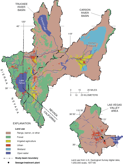
(click for full-size image; 46K) Figure 5. Although most land use in the Nevada Basin and Range Study Unit represents more natural conditions (forest and range), the Las Vegas and Reno-Sparks urban areas and irrigated agriculture in Carson Valley and Carson Desert are important land uses. |
Figure 6. Surface water provided more than 80 percent of the 990 million gallons per day withdrawn in the Nevada Basin and Range Study Unit. The water was used mostly for public supplies in the Las Vegas Valley (A) and for irrigation in the Carson and Truckee River Basins, combined (B).
(click for full-size image; 19K)
