![]()
The two major, historical mining areas in the Carson River Basin, the Leviathan Mine and the Comstock Lode (fig. 11), were operationally related for a time even though they were in widely separated parts of the basin [52]. The Leviathan Mine, in the California part of the East Fork Carson River drainage, produced copper sulfate used to refine silver from ore originating in the Comstock mines. The Leviathan Mine operated intermittently until 1962. During the Leviathan's active years, about 22 million tons of overburden containing large amounts of sulfide minerals were discarded in the area around the mine [5]. Bryant Creek, a tributary to the East Fork Carson River, drains most of the area occupied by the Leviathan Mine and enters the East Fork Carson River downstream from the Nevada-California border. Bryant Creek (fig. 3) and several of its tributaries receive acidic drainage and sediment from the mine area.
| In 1859, a silver- and gold-rich ore body (Comstock Lode) was discovered in the Carson River Basin, near what is now Virginia City, Nev. This discovery began a 20-year period (1860-80) of intensive ore processing in the upper and middle parts of the Carson River Basin. During this 20-year period, about 7,500 tons of elemental mercury were lost, mostly downstream from Carson City where mercury amalgamation was used to recover silver and gold from bulk ore [6]. High-grade silver ore was processed in stamp mills that were located along 8 mi of the Carson River beginning about 1,500 ft upstream from the Carson City sampling site (site 3). Ore tailings still exist along the Carson River, especially in the flood plains, and continue to erode into the river during periods of high streamflow. | 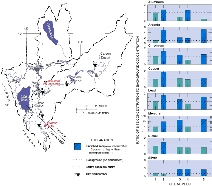
(click for full-size image; 42K) Figure 11. Carson River bottom sediments were enriched with aluminum, arsenic, copper, chromium, lead, mercury, and nickel from the Leviathan Mine and other mines; downstream from the Comstock Lode mining area, mercury and silver were enriched. |
The acidic drainage and erosion from the Leviathan Mine have enriched trace-element concentrations in stream-bottom sediment in the East Fork Carson River downstream from its confluence with Bryant Creek. Stream-bottom sediment at site 2 (fig. 11) was enriched with aluminum, arsenic, chromium, copper, lead, mercury, and nickel compared to upstream background concentrations [39]. The Leviathan Mine is probably the source of enriched aluminum, arsenic, chromium, copper, lead, and nickel [39]. Mercury in stream-bottom sediment of the East Fork Carson River probably was not from the Leviathan Mine (Thomas J. Suk, California Regional Water Quality Control Board, personal commun., 1997). Although the source of mercury is not known, geothermal discharge to the river and natural deposits and historical mining [53] of cinnabar (mercury sulfide) are two possible sources. This area is within one of three regions, worldwide, with economically extractable deposits of mercury ore [57].
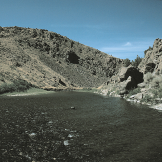
East Fork Carson River upstream from Carson Valley, September 1993. Photograph by Stephen J. Lawrence, U.S. Geological Survey. |
The effects of Comstock-era mining were seen in bottom
sediments throughout the lower Carson River and in Lahontan Reservoir.
Stream-bottom sediment near and downstream from Carson City (sites 3, 4,
and 5; fig. 11) was enriched from 3 to 25 times in silver or mercury compared
to site 1, the upstream background site [39]. Mercury coexists with silver
in the ore tailings because it was used in the amalgamation process to
separate the silver and gold from crushed ore during the Comstock era.
Mercury contamination is well documented in the lower Carson River from
Carson City to the Carson Desert [54,55,56,57].
Stream-bottom sediment collected upstream from Lahontan Reservoir (site 4) in 1992 by NAWQA personnel contained mercury concentrations that were much lower than those previously measured at this site [39]. Mercury concentrations in the previously collected bottom-sediment samples [54,55,56] were 3 to 40 times higher than in the bottom-sediment samples collected in 1992. These previous samples [54,55] included the top of 1.5 to 3 inches of bottom sediment, whereas bottom-sediment samples from the top 1 inch were collected in 1992. Thus, the sample collected in 1992 could be more influenced by the recent erosion of soil with low mercury concentrations than were samples from previous studies. |
Mining activity associated with the Comstock Lode in the Truckee River Basin was limited to processing ore around Washoe Lake (fig. 3), the headwater of Steamboat Creek that is tributary to the Truckee River downstream from the Reno-Sparks urban area. Ore from the Comstock mines was transported to the stamp mills near Washoe Lake and processed using mercury amalgamation.
Mercury concentrations in Truckee River stream-bottom sediment were
much less than in those of the Carson River [39]. However, Truckee
River bottom sediments were enriched by 20 to 25 times in mercury downstream
from its confluence with Steamboat Creek, as compared to an upstream background
site [39]. The enrichment may be a result of mercury lost during ore processing
in Washoe Valley and mercury in the discharge of geothermal water to Steamboat
Creek [24,25].