USGS banner

Hydrologic Benchmark Network Stations in the Midwestern U.S. 1963-95 (USGS Circular 1173-B)

Abstract and Map Index

List of all HBN Stations

Introduction to Circular 

Analytical Methods

Washington Creek at Windigo, Michigan (Station 04001000)

To download a printer friendly PDF version of this information click here.

This report details one of the approximately 50 stations in the Hydrologic Benchmark Network (HBN) described in the four-volume U.S. Geological Survey Circular 1173. The suggested citation for the information on this page is: 

Mast, M.A., and Turk, J.T., 1999, Environmental characteristics and water quality of Hydrologic Benchmark Network stations in the Midwestern United States, 1963-95: U.S. Geological Survey Circular 1173-B, 130 p.

All of the tables and figures are numbered as they appear in each circular.  Use the navigation bar above to view the abstract, introduction and methods for the entire circular, as well as a map and list of all of the HBN sites.  Use the table of contents below to view the information on this particular station.

Table of Contents

1. Site Characteristics and Land Use
2. Historical Water Quality Data and Time-Series Trends
3. Synoptic Water Quality Data

4. References and Appendices

Site Characteristics and Land Use

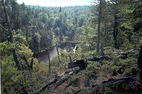
        The Washington Creek HBN Basin is located in the Superior Upland physiographic province on the southwest end of Isle Royale, which is the largest island in Lake Superior (Figure 12. Map showing study area in the Washington Creek Basin and photograph of the landscape of the basin). The 34-km² basin ranges in elevation from 184 to 425 m and drains a landscape of narrow northeast-trending ridges separated by flat stream valleys with numerous wetlands. The USGS gaging station is located 1.3 km northeast of the Windigo Ranger Station at latitude 47×55'23'' and longitude 89×08'42''. Washington Creek, which flows into Windigo Harbor in Lake Superior, has a channel length of about 10.9 km upstream from the gaging station and an average stream gradient of 9.7 m/km. The main channel is perennial, and mean monthly discharge varies from 0.10 m³/s in February to 2.0 m³/s in April during snowmelt. Streamflow normally peaks a second time in October and November owing to increased precipitation and low rates of evapotranspiration. Average annual runoff from the basin was 42 cm from 1965 through 1995 (Blumer and others, 1996). The climate is continental with short, cool summers and cold winters. The mean annual air temperature is 3.4×C, and average annual precipitation is 77 cm (Hansen and others, 1973). Winter snowfall generally begins in October and accumulates in a seasonal snowpack that typically reaches 45 to 60 cm in depth

Washington Creek (A. Mast)
Washington Creek 1

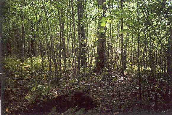
        The Washington Creek Basin is in the Laurentian Mixed Forest ecoregion, which is between the boreal forest and the deciduous forest zones (Bailey and others, 1994). The boreal forest type primarily grows in the northern part of the basin closest to the shoreline (Slavich and Janke, 1993). The predominant species in this area are white spruce, balsam fir, aspen, and paper birch. Farther south in the basin, the soils are thicker, and the climate is somewhat warmer; the forest primarily consists of mature stands of sugar maple and yellow birch. Wetland areas situated between the upland ridges are dominated by black spruce, white cedar, and fir, and some south-facing slopes have stands of jack pine. Most soils in the basin are classified as Spodosols and are mapped in the Graveraet-Michigamme-Rock outcrop soil association (U.S. Department of Agriculture, 1990a). This association is characterized by rock outcrops interspersed with moderately deep (60 to 90 cm), sandy to coarse loamy soils formed in glacial till and loamy mantle material over glacial till (Stottlemyer and Hanson, 1989). The soils tend to be acidic (pH 3.8 to 5.0) and have low exchangeable bases and organic-matter contents in the mineral horizon (Stottlemyer and Hanson, 1989).

        Bedrock underlying Isle Royale consists of a thick sequence of basaltic and andesitic lava flows with interbedded conglomerates and sandstones collectively referred to as the Portage Lake Volcanics of Precambrian age (Huber, 1973a, b). The lava flows and sedimentary layers dip to the southeast and are eroded to form a series of long, parallel ridges and valleys. The Washington Creek Basin is primarily underlain by flood basalts, which locally include some sedimentary units. The flood basalts are composed of plagioclase (An60) and pyroxene, which is predominantly augite. Ilmenite and magnetite are major accessory minerals, and chloride, sericite, and calcite are common secondary minerals (Huber, 1973b). Most bedrock in the basin is covered by talus, slopewash, and glacial drift deposits of Pleistocene age. Till deposits are deepest and most extensive in the southwestern part of the basin. The tills have a high carbonate content that probably is derived from calcareous deposits brought south from Hudson Bay by Pleistocene glaciers (Huber, 1973b).

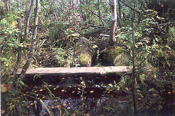
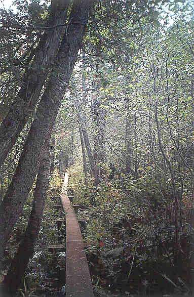
        The Washington Creek Basin is located in Keweenaw County in Michigan on the western end of Isle Royale in Lake Superior and is entirely in the boundaries of Isle Royale National Park. The basin is accessible by way of Windigo, on the western end of the island, by using seaplane service from Houghton, Mich. (118 km to the south), or by ferry service from Grand Portage, Minn. (35 km to the west). The park is open to the general public from April 15 to November 1, and regular transportation services operate from mid-June through October. During the winter, the site is accessible by ski plane or helicopter. The gaging station can be reached by a 1.7-km hiking trail from Windigo. The basin is undeveloped, except for two maintained hiking trails. A campground, ranger station, and weather station are located at Windigo, which is downstream from the gaging station.

Washington Creek (A. Mast)
Washington Creek 2

        Although the basin has remained undisturbed since the establishment of the National Park, the ecosystem has been modified by land uses in the past (Shelton, 1975). Mineral exploration for native copper deposits occurred in the Windigo area from 1889 to 1893, including an extensive drilling project to locate ore deposits. Although few deposits were ever mined, fire was commonly used by prospectors to remove vegetation from the bedrock. The only logging in the HBN basin occurred in the 1890's when white cedar and pine were cut along Washington Creek. Part of the basin was burned in 1936 when a logging-related fire destroyed almost one-third of the forest cover on the island. Natural factors also have affected the forests of Isle Royale, including spruce budworm epidemics and trends in the moose population (Hansen and others, 1973). The Civilian Conservation Corps constructed trails, fire towers, and buildings on the island in the 1930's, and the Isle Royale National Park was formally established in 1940. The management policies of Isle Royale National Park are described in the most recent version of the general management plan for the park (U.S. Department of the Interior, 1998). In addition to Washington Creek, water quality on Isle Royale also is monitored at the Wallace Lake study site (Stottlemyer and Hanson, 1989) located on the east end of Isle Royale approximately 40 km east of the HBN station. The Wallace Lake study site was established in 1982 as part of a network of field research sites in National Parks designed to study the structure and function of environmentally sensitive ecosystems and their response to disturbance, such as atmospheric contaminant inputs and global climate change (URL http://www.mesc.usgs.gov/norocky, accessed 1998).

Historical Water-Quality Data and Time-Series Trends

        The data set for the Washington Creek HBN Station analyzed for this report includes 146 water-quality samples that were collected from September 1967 through August 1995. Sampling frequency was monthly in 1968 and 1969, bimonthly from 1970 through 1982, and quarterly from 1983 through 1995. Water-quality samples in the early part of the period of record were analyzed at a USGS laboratory in Columbus, Ohio, that operated until 1973 (Durum, 1978). After establishment of the central laboratory system, samples were analyzed at a laboratory in Atlanta, Ga., from 1973 through 1985 and at the NWQL in Arvada, Colo., from 1986 through 1995. Daily discharge records for Washington Creek (station 04001000) are available beginning in October 1964. Records of daily water temperature at the gaging station are available from October 1964 through September 1991.

Washington Creek (A. Mast)
Washington Creek 3

       Calculated ion balances for 139 samples with complete major-ion analyses are shown in Figures 13a and 13b. Temporal variation of discharge, field pH, major dissolved constituents, and ion balance at Washington Creek, Michigan. Ion balances ranged from -8.9 to 13 percent, and about 80 percent of samples had values within the ±5 percent range, indicating that the analytical results are of high quality. The average ion balance was 1.5 percent, and 68 percent of the samples had positive ion balances, indicating a slight excess of measured cations over anions in solution. Time-series plots of the major dissolved constituents were inspected for evidence of method-related effects (fig. 13). The most notable pattern was observed in sulfate, which had a period of elevated concentrations during the late 1980's. This pattern coincides with the use of a turbidimetric titration for sulfate analyses at the NWQL in Arvada, Colo., between March 1986 and December 1989 (Fishman and others, 1994). In 1989, the laboratory determined that sulfate concentrations can be overestimated by this method and changed the method to ion chromatography in 1990 (Office of Water Quality Technical Memorandum No. 90.04, Turbidimetric Sulfate Method, issued December 21, 1989, at URL http://water.usgs.gov/admin/memo/, accessed 1997). The bias was most pronounced in dilute waters, although it was not consistent among samples and seemed to be affected by factors such as color and turbidity (Schertz and others, 1994). The positive bias in sulfate concentrations also is reflected in the ion balance, which was consistently lower than average during this period of record.

        Median concentrations and ranges of major constituents in stream water at the Washington Creek Station and VWM concentrations in wet-only deposition measured at the Wallace Lake NADP Station are listed in table 22. Precipitation chemistry at the NADP station, which is about 40 km east of the HBN station on the east end of Isle Royale, is dilute and slightly acidic with a VWM pH of 4.8 for 11 years of record. The predominant cations in precipitation were hydrogen and ammonium, which contributed 35 and 38 percent of the total cation charge. The predominant anions were sulfate, which accounted for 61 percent of the total anions, and nitrate, which accounted for 36 percent. The predominance of strong acid anions indicates that precipitation on Isle Royale may be affected by anthropogenic emissions of sulfur and nitrogen compounds, which cause acid rain (Stottlemyer and Hanson, 1989).

Table 22. Minimum, first quartile, median, third quartile, and maximum values of physical properties and major dissolved constituents measured in water-quality samples from Washington Creek, Michigan, September 1967 through August 1995, and volume-weighted mean concentrations in wet precipitation collected at the Wallace Lake Station, Michigan

[Concentrations in units of microequivalents per liter, discharge in cubic meters per second, specific conductance in microsiemens per centimeter at 25 degrees Celsius, pH in standard units, and silica in micromoles per liter; n, number of stream samples; VWM, volume-weighted mean; inst., instantaneous; spec. cond., specific conductance; <, less than; --, not reported]

Parameter

Stream Water

Precipitation VWMa

Minimum

First quartile

Median

Third quartile

Maximum

n

Discharge, inst.

0.014

0.065

0.15

0.48

4.4

145

--

Spec. cond., field

57

98

130

170

250

141

13

pH, field

6.6

7.3

7.5

7.7

8.1

145

4.8b

Calcium

360

650

900

1,050

1,600

145

7.9

Magnesium

180

330

420

530

800

145

2.2

Sodium

39

96

130

170

360

145

1.4

Potassium

<2.6

10

13

15

31

145

.7

Ammonium

<.7

1.4

2.1

2.9

26

61

17

Alkalinity, laboratory

400

820

1,220

1,510

2,120

145

--

Sulfate

8.3

92

120

160

460

142

29

Chloride

<2.8

51

85

140

420

146

1.6

Nitrite plus nitrate

<.7

3.6

7.1

7.1

15

102

17c

Silica

98

160

200

230

270

146

--

a Data are volume-weighted mean concentrations for 1985-95.

b Laboratory pH.

c Nitrate only.


Washington Creek (A. Mast)
Washington Creek 4

        Stream water in Washington Creek is moderately concentrated and well buffered; specific conductance ranged from 57 to 250 mS/cm, and alkalinity was generally between 820 and 2,120 meq/L (table 22). The major cations in stream water are calcium and magnesium, and bicarbonate is the predominant anion. The predominance of these solutes in stream water is attributed to the weathering of mafic minerals in the metavolcanic rocks and of carbonate minerals in glacial till. The median concentration of chloride in stream water was 85 meq/L, which is about 50 times greater than the VWM concentration of 1.6 meq/L in precipitation. On the basis of the difference between annual precipitation and runoff, evapotranspiration can account for not more than a twofold increase in the chloride concentration in precipitation, indicating that most stream-water chloride is derived from sources other than precipitation. The source of additional stream-water chloride is not obvious. Because the basin is undeveloped, the only plausible source of stream-water chloride is weathering of sedimentary rock fragments in the underlying glacial till. The median concentration of sulfate in stream water was 120 meq/L compared to 29 meq/L in precipitation, indicating as much as one-half of stream-water sulfate is derived from sources other than wet deposition. In a study on the east end of Isle Royale, Stottlemyer and Hanson (1989) determined that the flux of sulfate from dry deposition was almost twice that in wet-only precipitation, indicating that most stream-water sulfate at this station can be accounted for by atmospheric deposition. Concentrations of inorganic nitrogen species in stream water were less than the VWM concentrations in precipitation, indicating that most atmospheric nitrogen is retained by vegetation and soils in the basin.

        The solute composition of stream water was further evaluated by analyzing correlations between solutes and stream discharge (table 23). Most weathering-derived constituents, including chloride, had strong inverse correlations with discharge. These results are consistent with a hydrologic system where weathering-enriched base flow is diluted by water from shallow or surficial sources during periods of increased discharge, particularly spring snowmelt. Among the solutes, strong positive correlations were found among calcium, magnesium, sodium, alkalinity, chloride, and silica. Strong associations between base cations and silica probably reflect the weathering of plagioclase and pyroxene minerals in the volcanic rocks. The strong correlations between chloride and the weathering-derived solutes provide additional evidence that chloride is derived primarily from geologic sources in the basin. Likewise, the poor correlations between sulfate and the weathering-derived constituents are consistent with the assumption that sulfate is derived primarily from atmospheric sources.

Table 23. Spearman rank correlation coefficients (rho values) showing the relation among discharge, pH, and major dissolved constituents, Washington Creek, Michigan, 1968-95

[Q, discharge; Ca, calcium; Mg, magnesium; Na, sodium; K, potassium; Alk, alkalinity; SO4, sulfate; Cl, chloride; Si, silica]


Q

pH

Ca

Mg

Na

K

Alk

SO4

Cl

pH

-0.478


Ca

-.925

0.541


Mg

-.942

.539

0.967


Na

-.970

.496

.936

0.967


K

-.327

.311

.400

.413

0.350


Alk

-.957

.539

.963

.976

.955

0.361


SO4

.151

-.091

-.147

-.078

-.068

.211

-0.177


Cl

-.955

.483

.896

.920

.957

.340

.919

-0.053


Si

-.744

.287

.793

.843

.783

.345

.782

.076

0.747


        Results of the seasonal Kendall test for trends in discharge and major dissolved constituents are listed in table 24. A statistically significant (0.01 probability level) upward trend in pH and a downward trend in potassium were detected in the unadjusted and flow-adjusted concentrations. After flow adjustment, statistically significant trends also were detected in calcium, magnesium, and chloride concentrations. The LOWESS curves in figure 13 show that the trend in pH was primarily caused by a period of low pH values before 1980, and that most of the decrease in potassium concentrations occurred during the late 1970's and early 1980's. Because changes in pH and potassium occurred during relatively short periods of time, they may have been caused by method-related factors rather than by environmental change. The trend in field pH may have been caused by changes in field instruments and pH probes, whereas potassium concentrations probably were affected by changes in laboratory facilities or analytical methods. The trends in calcium, magnesium, and chloride concentrations probably were caused by environmental change rather than by method-related factors because the trends were only detected in flow-adjusted concentrations. Because the Washington Creek Basin has remained undisturbed since the establishment of the National Park, trends in stream chemistry probably do not reflect changes in land use. Other environmental factors that may have affected stream chemistry include long-term variations in climate and changes in atmospheric deposition. Analysis of long-term climatic records is beyond the scope of the report; however, Lawrence (1987) reported a statistically significant decline in annual mean discharge at the Washington Creek gaging station from 1965 through 1980, which was probably caused by trends in precipitation amount. Long-term records of precipitation chemistry are not available to help establish a link between trends in stream chemistry and changes in atmospheric deposition. However, Lynch and others (1995) did report statistically significant declines in calcium, magnesium, and chloride at several NADP stations in the north-central United States between 1980 and 1992.

Table 24. Results of the seasonal Kendall test for trends in discharge and unadjusted and flow-adjusted pH and major dissolved constituents, Washington Creek, Michigan, September 1967 through August 1995

[Trends in units of microequivalents per liter per year, except discharge in cubic meters per second per year, pH in standard units per year, and silica in micromoles per liter per year; inst., instantaneous; <, less than; --, not calculated]

Parameter

Unadjusted

Flow adjusted

Trend

p-value

Trend

p-value

Discharge, inst.

-0.001

0.602

--

--

pH, field

.01

.000

0.02

0.000

Calcium

-1.6

.264

-2.2

.006

Magnesium

-.4

.482

-1.2

.009

Sodium

<.1

.672

<.1

.975

Potassium

-.2

.000

-.2

.000

Alkalinity, laboratory

1.3

.592

-.5

.711

Sulfate

-1.7

.069

-1.7

.104

Chloride

-.7

.095

-.8

.001

Nitrite plus nitrate

.1a

.064

--

--

Silica

<.1

.724

<.1

.992

a Trend calculated for 1974-95 using a trend test for censored data.


Synoptic Water-Quality Data

        Results of the surface-water synoptic sampling in the Washington Creek Basin on September 20 and 21, 1992, are listed in table 25, and the locations of the sampling sites are shown in figure 12. During the sampling period, discharge at the gaging station was about 0.2 m³/s compared to the median daily discharge of 0.1 m³/s for September and 0.2 m³/s for October (Lawrence, 1987), indicating that the basin was sampled during normal flow conditions for that time of year. The solute concentrations measured at site 1 were between the first-quartile and median concentrations reported for the HBN station during the entire period of record (table 22), except for sulfate, which was less than the first- quartile concentration. The tributary streams were similar in composition to stream water collected at the gaging station (site 1); calcium and magnesium were the predominant cations, and bicarbonate was the predominant anion. Although not measured, organic anions probably were an important component of stream chemistry based on the tealike color of the stream water and the positive ion balances of most of the synoptic samples (range 0.1 to 8.5 percent). Concentrations of the weathering-derived solutes did not vary by more than a factor of two among the sampled tributaries, probably reflecting the small basin size and the relatively homogeneous composition of the underlying bedrock and glacial till deposits. Calcium, for example, ranged from 650 to 1,050 meq/L, and alkalinity ranged from 860 to 1,620 meq/L. The lowest concentrations of weathering constituents were measured at sites 6 and 7, perhaps because of the large wetland areas in these two sub basins. Among the minor solutes, chloride and sulfate concentrations had the most variability; chloride concentrations ranged from 8.5 to 59 meq/L, and sulfate concentrations ranged from 15 to 81 meq/L. Chloride was higher at the HBN station than at any of the upstream sampling sites, indicating that ground-water discharge along the lower reach of the stream channel is probably the source of most stream-water chloride at the HBN station. The range of stream-water sulfate concentrations probably cannot be accounted for by differences in atmospheric deposition because of the small basin size. Alternatively, this variation may reflect the influence of wetland areas along the streams where sulfate may be removed because of reducing conditions in the wetland soils.

Table 25. Physical properties and major dissolved constituents from surface-water sampling sites in the Washington Creek Basin, Michigan, collected September 20-21, 1992

[Site locations shown in fig. 12; Q, discharge in cubic meters per second; SC, specific conductance in microsiemens per centimeter at 25 degrees Celsius; pH in standard units; Ca, calcium; Mg, magnesium; Na, sodium; K, potassium; Alk, alkalinity; SO4, sulfate; Cl, chloride; NO3, nitrate; Si, silica; concentrations in microequivalents per liter, except silica in micromoles per liter; --, not reported]

Site

Station number

Q

SC

pH

Ca

Mg

Na

K

Alk

SO4

Cl

NO3

Si

Remarks

1

4001000

0.19

120

7.8

800

370

100

9.5

1,160

33

59

1.1

180

Gaging station

2

475547089074700

.024

110

7.9

750

390

96

12

1,100

23

20

2.1

170

--

3

475601089075000

--

160

7.8

1,050

540

110

13

1,620

81

14

1.4

280

--

4

475608089075300

.0056

110

7.7

700

380

100

12

1,060

58

17

1.6

120

--

5

475553089074800

.0046

120

7.7

750

410

100

12

1,140

65

8.5

1.6

140

--

6

475735089041600

.0069

100

7.5

700

380

100

6.2

980

29

25

.4

170

Primarily wetlands

7

475751089033900

--

90

6.8

650

340

96

7.2

860

23

42

.8

200

Primarily wetlands

8

475613089051900

.10

100

7.4

700

340

87

6.2

1,000

15

39

.9

150

Major tributary

9

475611089051700

.038

130

7.8

900

380

91

11

1,320

40

8.5

2.3

200

Major tributary


References Cited

Bailey, R.G., Avers, P.E., King, T., and McNab, W.H., eds., 1994, Ecoregions and subregions of the United States with supplementary table of map unit descriptions: Washington, D.C., U.S. Department of Agriculture Forest Service, scale 1:7,500,000(also at URL http://www.fs.fed.us/land/ecosysmgmt/ecoreg1_home.html, accessed 1998).

Blumer, S.P., Behrendt, T.E., Ellis, J.M., Minnerick, R.J., LeuVoy, R.L., and Whited, C.R., 1996, Water resources data, Michigan, water year 1995: U.S. Geological Survey Water-Data Report MI-95-1, 320 p.

Durum, W.H., 1978, Historical profile of quality of water laboratories and activities, 1879-1973: U.S. Geological Survey Open-File Report 78-432, 235 p.

Fishman, M.J., Raese, J.W., Gerlitz, C.N., and Husband, R.A., 1994, U.S. Geological Survey approved inorganic and organic methods for the analysis of water and fluvial sediment, 1954-94: U.S. Geological Survey Open-File Report 94-351, 55 p.

Huber, N.K., 1973a, Glacial and postglacial geologic history of Isle Royale National Park: U.S. Geological Survey Professional Paper 754-A, 15 p.

Huber, N.K., 1973b, The Portage Lake Volcanics (middle Keweenawan) on Isle Royale, Michigan: U.S. Geological Survey Professional Paper 754-C, 32 p.

Hansen, H.L., Krefting, L.W., and Kurmis, Vilis, 1973, The forest of Isle Royale in relation to fire history and wildlife: Agricultural Experiment Station Technical Bulletin 294, Forestry Series 13, 43 p.

Lawrence, C.L., 1987, Streamflow characteristics at hydrologic benchmark stations: U.S. Geological Survey Circular 941, 123 p.

Lynch, J.A., Grimm, J.W., and Bowersox, V.C., 1995, Trends in precipitation chemistry in the United States-A national perspective, 1980-1992:Atmospheric Environment, v. 29, no. 11, p. 1231-1246.

Schertz, T.L., Wells, F.C., and Ohe, D.J., 1994, Sources of trends in water-quality data for selected streams in Texas, 1975-89 water years: U.S. Geological Survey Water-Resources Investigations Report 94-4213, 49 p.

Shelton, Napier, 1975, The life of Isle Royale: Washington, D.C., National Park Service, Natural History Series, 142 p.

Slavich, A.D., and Janke, R.A., 1993, The vascular flora of Isle Royale National Pare: Houghton, Michigan, Isle Royale Natural History Association, 50 p.

Stottlemyer, R., and Hanson, D.G., Jr., 1989, Atmospheric deposition and ionic concentrations in forest soils of Isle Royale National Park: Soil Science Society of America Journal, v. 53, no. 1, p. 270-274.

U.S. Department of Agriculture, 1990a, General soil map, Isle Royale National Park, Michigan: U.S. Department of Agriculture Natural Resources Conservation Service, scale 1:190,080.

U.S. Department of the Interior, 1998, Final environmental impact statement for the general management plan, Isle Royale National Park, Michigan: Denver, National Park Service, Denver Service Center.


Appendix A. List of Map References

a.         U.S. Geological Survey topographic maps:

b.         Geologic maps:

c.         Soil surveys:

d.         Miscellaneous maps:


Appendix B. NWIS Site-Identification Numbers

Table B-1.  NWIS site-identification numbers and site names for water-quality sampling sites.

Site

Identification Number

Site Name

            1

04001000

WASHINGTON CR AT WINDIGO ISLE ROYALE MICHIGAN

            2

475547089074700

TWICE TRIED TRIB ISLE ROYALE MICHIGAN

            3

475601089075000

TRIB AT TRAIL CROSSING ISLE ROYALE MICHIGAN

            4

475608089075300

BURN AREA TRIB ISLE ROYALE MICHIGAN

            5

475553089074800

FIRST DAY TRIB ISLE ROYALE MICHIGAN

            6

475735089041600

GRASSY TRIB ISLE ROYALE MICHIGAN

            7

475751089033900

SWAMPY TRIB ISLE ROYALE MICHIGAN

            8

475613089051900

N FORK WASHINGTON CR ISLE ROYALE MICHIGAN

            9

475611089051700

S FORK WASHINGTON CR ISLE ROYALE MICHIGAN


Back to 1173-B Contents


This page maintained by Nichole Bisceglia.
Last updated July 17, 2000.