
DESIGN OF THE LONG ISLANDNEW JERSEY STUDY
| The LINJ study design focused on collecting data (table 6) that would add to current knowledge of contaminants in water, sediment, and fish tissue and improve the understanding of their occurrence, their biological effects, and the processes governing their occurrence and movement (Gilliom and others, 1995). |
Samples of stream water (over a range of flow conditions) and stream ecology
(once each year) were collected at seven fixed sites (fig. 35a; basic
and intensive, table 6). Samples for chemistry and ecology also were collected
once at 45 synoptic sites (fig. 35b). Streambed sediments were sampled
once at 14 sites (fig. 35a); samples of whole fish or fish livers were
collected at 8 of these sites. Sediment cores were collected once from
four lakes (fig. 35a). Streambed sediment and fish fillets were collected
once for mercury and methylmercury at four stream sites (fig. 35a).
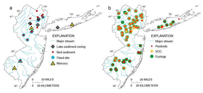 |
| Figure 35. Stream-sampling sites included (a) fixed sites, bed-sediment and mercury synoptic sites, and lake-sediment coring sites, and (b) pesticide, VOC, and ecological synoptic sites. |
Ground-water samples (table 6) were collected from 220 wells in surficial
aquifers that are sources of drinking-water supply. Monitoring wells were
installed in the Kirkwood-Cohansey aquifer system underlying 30 new urban
(less than 25 years old), 20 old urban (greater than 25 years old), 15
agricultural, and 13 undeveloped land-use settings and each well was sampled
once (fig. 36a). Water-quality data from these 78 wells, from 30 deeper
monitoring wells collocated with urban monitoring wells, from 30 public-supply
wells, and from 3 streams were used in a modeling analysis of how contaminants
enter and move through the aquifer to water-supply wells and streams.
Domestic-supply wells were sampled to assess water quality in three major
aquifer systemsthe Kirkwood-Cohansey aquifer system (30 wells) and the
fractured-bedrock aquifer systems of the New England (30 wells) and Piedmont
(22 wells) Physiographic Provinces (fig. 36b).
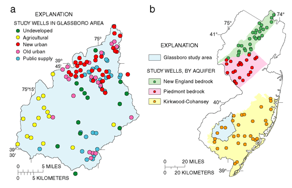 |
| Figure 36. Ground-water sampling sites included (a) land-use monitoring wells and public-supply wells and (b) domestic-supply (household) wells. |
Table 6. Summary of data collection in the Long Island-New Jersey Coastal Drainages study, 1996-98
|
Study component |
What data were collected and why |
Number and types of sites sampled |
Sampling frequency and period |
|---|---|---|---|
|
Stream Chemistry |
|||
|
Basic-fixed sites |
Nutrients, suspended sediment, major ions, organic carbon, field parameters (streamflow, dissolved oxygen, water temperature, pH, and specific conductance), and 1 year of 87 pesticides and 85 volatile organic compounds (VOCs). Fixed sites measure how often and how much of a constituent is found, over time, due to different seasonal or land-use patterns. |
Includes 5 sites that represent typical urban, agricultural, and/or mixed land-use basins--3 smaller basins that are indicative of an intensive urban residential (Saddle River), a developing urban (Stony Brook), and an agricultural (Neshanic River) land use and 2 larger basins (Passaic and Raritan Rivers) that integrate mixed land uses. Drainage areas range from 20 to 804 square miles (mi2) in size. |
Monthly and storm events, 1996-98; flow and stream temperature measured hourly. |
|
Intensive-fixed sites |
Same as above but sampled more for pesticides and VOCs. To determine how often and how much of a constituent is found, over time, due to different seasonal or land-use patterns. |
Includes 2 smaller (16-44 mi2) sites. Bound Brook represents intensive urban residential/commercial land use in northern N.J. and Great Egg Harbor River represents urban/mixed land use in the Coastal Plain. |
Biweekly to monthly and storm events, 1996-98; flow, stream temperature, and specific conductance measured hourly. |
|
Long-term site |
Same constituents as above. To determine changes or trends in chemistry over time. |
Only 1 site, Raritan River at Queens Bridge (804 mi2) that integrates mixed land uses in northern N.J. |
Monthly, quarterly only for VOCs, 1999 to next cycle. |
|
Synoptic sites |
Nutrients, organic carbon, suspended sediment, field parameters, 47 pesticides, and 85 VOCs were sampled. To measure how much a constituent changes, over the area, due to different land- or chemical-use patterns. |
Includes 45 sites over a full range (gradient) of urban land use (3-96 percent) and a range in drainage area from 16 to 180 mi2. |
Once; VOCs in January 1997; pesticides/ nutrients--most in June 1997 but some in June 1998. |
|
VOC-source surveys |
Field parameters and 85 VOCs were sampled. To evaluate VOC sources within selected basins for different flow conditions. |
Includes 11 sites within urban basins during winter base-flow conditions and 3 sites within the Bound Brook basin 4-6 times during a spring storm. |
Once during base flow in January 1997, 3 sites 4-6 times during a storm in April 1998. |
|
Stream Ecology, Fish Tissue, Streambed Sediments, and Lake Sediments |
|||
|
Ecological fixed sites |
Algal, benthic-invertebrate, and fish communities and the condition of stream habitat sampled. To measure how much the communities vary due to land-use patterns, location, and time. |
Includes 7 sites that are collocated with the 7 chemistry fixed sites. Two of the 7 sites also had 2 additional samples upstream and downstream from these fixed sites. |
Single stream reach (200-400 meters) once each year in August-October 1996-98; multiple reaches only in 1998. |
|
Ecological synoptic sites |
Same as stream ecology fixed sites above except reduced stream habitat and fish collected only at selected sites. To measure how much the communities differ due to land use. |
Includes 43 sites that are collocated with the chemistry synoptic sites over a full range of urban land use (3-96 percent). Drainage area ranged from 16 to 180 mi2. Fish data collected at 16 sites. |
Single reach, only once, most in August-October 1996; Coastal Plain sites in 1997-98. |
|
Streambed-sediment and fish tissue sites |
Organochlorine pesticides and other hydrocarbons, in sieved sediments and whole fish tissue. Trace elements in sieved sediments and fish livers. To measure how much a constituent changes due to different land- or chemical-use patterns. |
Includes 14 bed-sediment and 8 tissue sites--7 sites that are collocated with the 7 chemistry fixed sites and, to complement existing data, also with the synoptic sites, 7 sites for bed sediment and 1 for tissue. |
Once in September-October 1997. |
|
Lake-sediment coring sites |
Organochlorine pesticides, other hydrocarbons, and trace elements at multiple depths in cored sediments. To determine the changes (trend) in basin inputs over time due to different land- or chemical-use patterns. |
Includes 4 lakes. From least to most developed watershed--Clyde Potts Reservoir (undeveloped), Packanack Lake (urban residential), Orange Reservoir (urban residential and commercial), and Newbridge Pond (urban residential and commercial). |
Once in September 1997. |
|
Mercury synoptic sites |
Mercury, methylmercury, and acid-volatile sulfides in bed sedment and fish fillets. To evaluate factors for mercury occurrence and methylation potential nationwide. |
Includes 4 stream sites over a range in land use as part of a larger national mercury synoptic survey. From least to most urban--Muddy Run (agriculture), and Passaic, Great Egg Harbor, and Swan Rivers. |
Once in July 1997. |
|
Ground-Water Chemistry |
|||
|
Land-use monitoring-well surveys |
Nutrients, major ions, organic carbon, field parameters, 85 VOCs, 106 pesticides. To measure the effects of land use on shallow ground-water quality. |
Installed 78 monitoring wells 10 feet below the water table underlying new urban (< 25 years), old urban (> 25 years), agricultural, and undeveloped land-use settings in the Kirkwood-Cohansey aquifer system of the 400-mi2 Glassboro study area, N.J. |
Once in fall 1996. |
|
Flow-path monitoring wells |
Same as land-use surveys above except 47 pesticides. To evaluate the quality of ground water recharged in urban areas 10-20 years ago. |
Installed 30 monitoring wells 40-50 feet below the water table, collocated with 30 of the urban land-use monitoring wells. |
Once in fall 1997. |
|
Household (domestic) well surveys |
Same as land-use surveys plus some trace elements (reduced to 87 pesticides; Piedmont, 47 pesticides). To measure water quality representative of major aquifer subunits. |
Includes 82 household (domestic) wells in 3 major aquifer systems; 30 wells in the New England, 22 in the Piedmont fractured bedrock aquifers, and 30 in the Kirkwood-Cohansey aquifer system. |
Once; New England and Piedmont in 1997, Kirkwood-Cohansey in 1998. |
|
Community supply well survey |
Same as land-use surveys. Used in a modeling analysis, along with land-use survey, flow-path survey, and stream data. To better understand how contaminants enter and move through the aquifer to water-supply wells and streams. |
Includes 30 community (public)-supply wells in the Glassboro area (Kirkwood-Cohansey aquifer system). |
Once in 1997 or 1998. |
| Table of Contents || Previous Section || Next Section || Glossary U.S. Geological Survey Circular 1201 Suggested citation:
|
