
INTRODUCTION TO THE ALLEGHENY AND MONONGAHELA RIVER BASINS
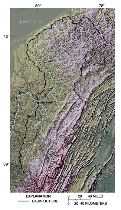 |
| Figure 1. The Allegheny and Monongahela River Basins lie almost entirely within the Appalachian Plateaus Physiographic Province. The eastern parts of the basins are more mountainous, the west is characterized by rolling hills, and the northwest has relatively low relief as a result of being covered by glaciers in the last ice age.The topography affects land use, exposed geologic formations, and stream habitatall of which, in turn, affect the quality and uses of water. |
The Allegheny and Monongahela Rivers join at Pittsburgh, Pa., forming the Ohio River. Historically, these rivers served as a transportation corridor to the West and were of strategic military significance. The Allegheny and Monongahela River Basins were at the focus of the industrial revolution in the United States. In 1990, approximately 4.2 million people lived in the area, and although the land and water uses have changed many times, the legacy of past activities is evident. Todays stream quality reflects a blend of past and present land uses and the natural quality and quantity of the water in these basins.
Topography and Geology
The Allegheny and Monongahela River Basins (ALMN) lie almost entirely within the Appalachian Plateaus Physiographic Province. The entire study area is underlain by sedimentary rocks that have been fractured in many places by folding and faulting. These rocks carry ground water in much of ALMN and are referred to as fractured-rock aquifers. The northwestern parts of the Allegheny River Basin were glaciated. The glaciers deposited sand, gravel, silt, and clay in the valleys and eroded the hills, leaving a terrain of more consistent altitude (Becher, 1999; McAuley, 1995). The glaciofluvial and alluvial deposits overlying the sedimentary rocks are generally much more permeable and comprise the valley-fill aquifers (Risser and Madden, 1994). Glaciofluvial deposits include sediments left by water flowing within, under, or out of glaciers. In contrast, the Appalachian highlands to the east and southeast have steep, high peaks, ridges, and plateaus that are deeply divided by valleys (fig. 1).
Land use is limited by the rough terrain and nutrient-poor soil in much of ALMN, both of which make large agricultural fields impractical. Urban areas generally lie along river valleys. Ridgetops are commonly forested, even in otherwise urban settings.
Ecologically, the streams of these basins present a diversity of habitats. Mountainous areas are generally dominated by streams that are very low in nutrients and remain cold all year. These streams support trout and a few other cold-water fish species but commonly include diverse aquatic-invertebrate populations. Streams along the western side of ALMN are generally warm-water systems with a much greater diversity of fish species.
Water Use
Most water (94 percent) used in ALMN is drawn from surface-water sources. In 1995, 82 percent of water withdrawn in ALMN was for industrial uses or thermoelectric power generation. Although ground-water withdrawals are proportionally small, they are important for public supply or domestic use, especially in rural areas (fig. 2).
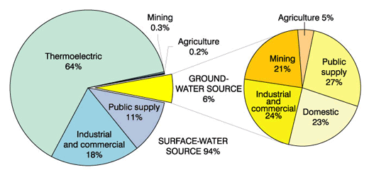 |
| Figure 2. In 1995, water withdrawn averaged 3,284 million gallons per day. In the Pittsburgh area, nearly all water used for public supply is surface water. Ground water provides water for domestic use in most rural areas. |
Reservoirs have been in place in the study area for more than 150 years for flood control (fig. 3), recreation, navigation, power generation, water quality, and water supply. Nearly all major tributaries have reservoirs constructed on them. The entire length of the Monongahela River and the lower 72 miles of the Allegheny River are maintained for navigation by dams. During dry periods, low streamflows are augmented by reservoir releases to dilute degraded water (Ohio River Basin Commission, 1980).
Nonconsumptive use of the water resource also is extensive in ALMN. Some streams are managed for whitewater sports, boating, or fishing, and some high-quality stream reaches are important for conservation and management of endangered species.
|
|
| Figure 3. One of the most devastating floods in United States history occurred in the Allegheny River Basin on May 31, 1889. A dam upstream from Johnstown, Pennsylvania, failed. Downstream, 2,209 people were killed and thousands more were injured. (Photograph used with permission from the National Park Service.) |

Hydrologic Conditions
Although streamflow roughly followed normal patterns during 199698, flows were substantially higher or lower than normal for short periods in response to weather extremes (fig. 4). Hence, the ALMN water-quality data set includes responses to a wide range of flows while still being largely representative of normal conditions.
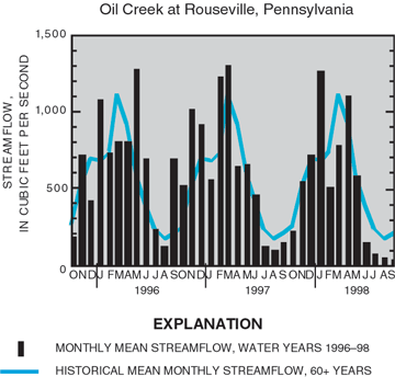 |
| Figure 4. Streamflow was above average in 199697 and below average in summer 1998. |
| Table of Contents || Previous Section || Next Section || Glossary U.S. Geological Survey Circular 1202 Suggested citation:
|
