
MAJOR FINDINGS—Continued
Fish Communities Differ Considerably Throughout the Basin, but Non-native Species Continue to Expand Their Range
Fish communities in the KanawhaNew River Basin are complex and vary widely among streams of different size, physiographic setting, and land use. Individual species are distributed in patches, particularly upstream from Kanawha Falls (Jenkins and Burkhead, 1994). This patchy distribution can confound comparisons among streams (Strange, 1999). The quality of the regional fish community is generally good, although the national NAWQA fish index seems to underrate that quality because it does not consider the patchy distribution.
Non-native Fish Continue to Expand Their Range in Tributaries of the New and Gauley Rivers
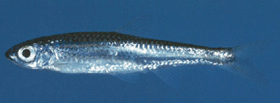 |
| Figure 17. Example of a telescope shiner (Notropis telescopus), a non-native species in the Kanwha–New River Basin. (Photograph from Jenkins and Burkhead, 1994; used by permission from the Virginia Department of Game and Inland Fisheries) |
Three fish species were collected for the first time at often-sampled sites in tributaries of the New and Gauley Rivers (Cincotta and others, 1999). Margined madtoms, a popular bait species, were collected for the first time from Second Creek near the village of Second Creek. Margined madtoms are native to some parts of the New River and some of its tributaries, but they had never before been collected from the Greenbrier River Subbasin. Telescope shiners (fig. 17), natives of the Tennessee River Basin, have been collected in the New River since 1958, and they continue to expand their range. Telescope shiners were collected from another often-sampled site, Williams River at Dyer, in the Gauley River Subbasin; this was their first collection upstream from Summersville Dam, a large impoundment. Telescope shiners also were collected for the first time from two Meadow River tributaries, also in the Gauley River Subbasin. Least brook lamprey were collected for the first time from Williams River at Dyer, their second collection from the Gauley River Subbasin. Populations of all these species were well established, and the ongoing expansion of their ranges suggests that all were relatively recent bait-bucket introductions to the New River system. Two of these reaches, and all of these streams, had been thoroughly sampled in the late 1970s (Hocutt and others, 1978, 1979).
Other fish collected for the first time in the basin were in tributaries of the Coal River. The new species in Coal River distribution records were from large tributaries where few or no surveys had been made since the 1930s. Mottled sculpin, bluebreast darter, river carpsucker, blacknose dace, and longnose dace all were collected for the first time from Clear Fork near Whitesville or Spruce Laurel Fork at Clothier, major tributaries to the Big or Little Coal Rivers, respectively. Several of these records represented the most upstream collections in their respective forks of the Coal River, although all had been collected from the Coal River Subbasin. These new-species records most likely represent undersampling of streams that have often been overlooked by investigators rather than new range expansions.
In some regions of the United States, the highest proportion of non-native fish are typically present in the most impaired streams (Maret, 1997; Waite and Carpenter, 2000). In these regions, unimpaired streams are typically cold-water streams with complex physical habitat and low nutrient concentrations. In impaired streams where agricultural and urban land uses are common, stream temperature and nutrient concentrations are high and physical habitat is degraded. Many non-native fish tolerate these conditions better than many native species do, enabling the non-natives to displace the natives. No such relation was found in the KanawhaNew River Basin, where sedimentation and increased dissolved solids have impaired streams, but where temperature and nutrient concentrations have remained low (Messinger and Chambers, 2001, in press). The proportion of introduced fish in the New River system was high, even though other measures did not indicate impairment.
Fish Species Common Throughout the Ohio River Basin are Not Native Upstream from Kanawha Falls
The New River system, which fisheries biologists consider to include the Gauley River and its tributaries, supports a different collection of fish species than the downstream Kanawha River system, which is part of the larger Ohio River system (Jenkins and Burkhead, 1994). Kanawha Falls (see front cover), a 24-foot waterfall 2 miles downstream from the confluence of the New and Gauley Rivers, is the boundary between the New River and Kanawha River systems. This waterfall has been a barrier to upstream fish movement since glaciers affected streams more than 1 million years ago. The New River system lacks native species diversity, and it has unfilled ecological niches. It has only 46 native fishes and the lowest ratio of native fishes to drainage area of any river system in the Eastern United States.
The lack of native-species diversity allowed other species to develop in the New River system, which has the largest proportion of endemic species (found nowhere else in the world) in eastern North America (8 of 46). Introduced fish species have prospered in the New River system; Jenkins and Burkhead (1994) cite the New River system as having the largest number and proportion (42 of 89) of introduced freshwater species of all major eastern and central North American drainages.
Although many species have been introduced and become naturalized throughout the 19th and 20th centuries, the New River fish fauna remain susceptible to invasion. In contrast, 118 fish species are reported from the Kanawha River system downstream from Kanawha Falls (Stauffer and others, 1995); none of these fish species are endemic to the Kanawha River system, and only 15 are considered possible, probable, or known introductions.
Fish Communities are Controlled By a Variety of Environmental Factors in the KanawhaNew River Basin
In testing the possible effects of coal mining on fish communities, results were less definitive than for benthic invertebrates (p. 89). No common fish metrics (Karr and Chu, 1999; Barbour and others, 1999) correlated closely with mining intensity or its surrogate, sulfate concentration. The study included sites both upstream and downstream from Kanawha Falls, and differences in many metrics between the two groups mask differences among land-use categories (Messinger and Chambers, 2001, in press). However, fish were collected at only 13 wadeable sites in the coal region, which did not represent a full gradient of mining intensity.
High Concentrations of Fecal Bacteria Remain in Streams if Sources are Close
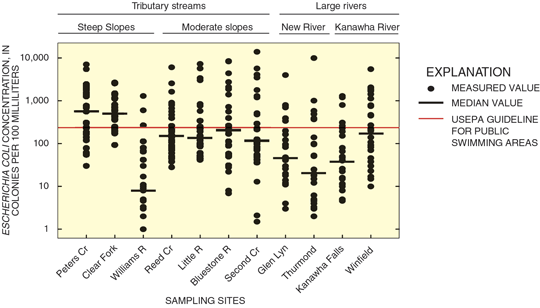
Concentrations of Escherichia coli (E. coli) exceeded the national guideline for public swimming areas in 26 percent of samples from major rivers in the KanawhaNew River Basin and in 43 percent of samples from tributary streams (fig. 18); however, no outbreak of waterborne disease was reported from the basin during 199198 (Barwick and others, 2000). Bacteria concentration in stream water varies widely, reflecting the changing balance between bacterial sources and many factors that help or hinder bacteria transport. Because of the wide variability, comparisons between streams based on only a few samples can be misleading; a few generalizations, however, can be made.
 |
| Figure 18. E. coli bacteria concentrations in streams vary widely. |
First, streams contain more bacteria if the sources are close to the stream and the sampling site. Among large rivers, median concentrations of E. coli were lowest in the New River Gorge at Thurmond, in a reach distant from any large city (fig. 18). Concentrations were highest in the Kanawha River downstream from the Charleston metropolitan area at Winfield. In the two tributary basins with the highest median concentrations, most homes are clustered close to the streams because the land slopes steeply elsewhere. In contrast, four tributary streams in basins with more moderate slopes, where bacteria sources are more dispersed, had median E. coli concentrations less than half as high. Regardless of slope, direct contamination of a stream by sewage or manure can produce extremely high concentrations, as Gillies and others (1998) observed in the Greenbrier River.
 |
| Figure 19. Guidelines for E. Coli are exceeded more often in winter than in summer for most streams. |
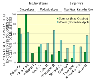
Second, bacteria concentrations exceeding guidelines are much more common when streamflow is greater than average, so streams generally contain more bacteria in winter than in summer (fig. 19). E. coli concentrations exceeded guidelines in less than one-third of summer samples from moderate-slope tributaries and less than one-fifth from large rivers. In the three tributary basins with steeper slope, however, concentrations were higher in summer than winter.
Finally, streams contain more bacteria if the bacteria sources are large. Williams River, the tributary basin with the lowest median concentration of E. coli (fig. 18) is home to only 5 people per square mile, compared to the average of 71 people per square mile throughout the entire KanawhaNew River Basin. For twice the population density, median E. coli was about 300 percent higher among steep-slope tributaries. Among the moderate-slope basins, however, including the Bluestone River Basin with 201 people per square mile, median E. coli was only about 10 percent higher for twice the population density. Neither the estimated number of cattle nor the percentage of agricultural land use in the tributary basins showed a relation to the median bacteria concentrations.
| Facts about E. coli |
Nutrient and Organic-Chemical Concentrations in Surface Water are Low in Most of the Basin
Nutrients were Detected at Low Concentrations in Streams of the KanawhaNew River Basin
Mean concentrations of nutrients in the KanawhaNew River Basin were at or below national background levels. Most concentrations, however, exceed those measured at a stream-water-monitoring site at Williams River, which drains mostly National forest. The highest mean nitrate concentration measured was 1.5 mg/L. Flow-weighted mean ammonia concentrations ranged from less than 0.02 to 0.04 mg/L. Mean total phosphorus concentration was less than 0.1 mg/L at nine sites; the maximum was 0.15 mg/L. Nitrate and phosphorus are typically increased by agricultural or urban land uses, and certain nutrients, such as ammonia, can accumulate from natural sources.
 |
| Figure 20. Because much of the Kanawha–New River Basin is forested, surface water and ground water contain low concentrations of nutrients and few pesticides. |
Differences in nutrient concentrations were found among sites because of differences in land use/land cover, and physiography. Generally, basins with more agriculture produced more mean total nitrogen than did forested basins. The lowest mean total nitrogen concentration in streams, 0.71 mg/L was that for mostly forested tributary basins in the Appalachian Plateaus produced (fig. 20). The lowest mean concentration in the basin, or background concentration, was 0.45 mg/L, at Williams River. Tributary streams with basins mostly or wholly within the Valley and Ridge Physiographic Province had the highest mean total nitrogen, 1.04 mg/L. One stream in the Blue Ridge had a mean total nitrogen concentration of 0.94 mg/L. The mean total nitrogen concentration was not substantially different between large rivers and smaller tributaries (0.83 and 0.90 mg/L respectively).
Four sites, draining forest mixed with agriculture or coal mining, ranked among the best sites in the Nation in a national Algal Status Index. This index measures the proportion of algal samples that belong to species that are tolerant of high nutrient concentrations and siltation.
Pesticides were Detected at Low Concentrations in Surface Water
Pesticides were sampled for 9 to 25 times at four sites in 1997. Two sites were on mainstem, large streams. The other two sites on tributary streams drained basins with more than 30 percent agricultural land and some urban land. (See Study Unit Design, p. 20). Time of sampling covered the seasonal spectrum of both climate and pesticide application. The pesticides detected at all sites are routinely detected at agricultural sites across the Nation.
Surface-water samples in the KanawhaNew River Basin contained only a few pesticides at low levels. In all, 23 of 83 pesticides analyzed for were detected (Ward and others, 1998). All pesticide detections were less than 1 µg/L; concentrations detected did not exceed USEPA drinking-water standards or aquatic-life criteria. The most commonly detected pesticides were atrazine, deethylatrazine (a breakdown product of atrazine), metolachlor, prometon, simazine, and tebuthiuron. Atrazine, deethylatrazine, metolachlor and simazine were detected in more than 90 percent of samples.
Dioxin is a particularly toxic contaminant in certain herbicides formerly manufactured near Charleston and is a known contaminant in the lower Kanawha River, but it was not analyzed for this study. Dioxin in the lower Kanawha River is the target of ongoing regulatory investigations by USEPA and other agencies.
Many VOCs Detected in the Lower Kanawha River
Numerous volatile organic compounds (VOCs) have been detected routinely at low concentrations in the Kanawha River downstream from the Charleston metropolitan area (Tennant and others, 1992). In this study, more than 20 VOCs were detected, at concentrations ranging from 0.015 to 0.3 µg/L, in each of two samples collected in late 1997 from the Kanawha River at Winfield. Each sample was analyzed for 85 compounds (Ward and others, 1998). The compounds detected at Winfield, downstream from Charleston, included chloroform, motor fuel and aromatic compounds such as benzene, and industrial compounds such as ethers. In contrast, only a single compound was detected in one of two samples collected from the Kanawha River upstream at Kanawha Falls.
During 198796, one or more of 21 VOCs were detected in 50 percent of all daily samples collected for the Ohio River Valley Water Sanitation Commission (ORSANCO) from an industrial water intake at St. Albans, downstream from Charleston (Lundgren and Lopes, 1999). Benzene and toluene were the two most frequently detected compounds, and a maximum of 11 compounds was detected in a single sample. Median concentrations ranged from 0.1 to 2.3 µg/L. Gasoline spills or leaks of as little as 10 gallons per day that reach the river could produce the concentrations measured at St. Albans.
Radon Concentrations and Bacterial Contamination are the Principal Ground-Water-Quality Concerns
Physiographic Province, Geology, Well Construction, and Land Use Affect the Quality of Water from Domestic Wells
Ground water from private wells provides domestic supply for 30 percent of the people in the KanawhaNew River Basin. High concentrations of radon are a concern in the Blue Ridge (p. 18), and private wells can be contaminated by fecal bacteria throughout the basin (p. 19), but the occurrence of other contaminants differs among the physiographic provinces.
Appalachian Plateaus Physiographic Province
In the layered sedimentary rocks of the Appalachian Plateaus, ground water moves mostly in a network of narrow fractures within a few hundred feet of the land surface (Wyrick and Borchers, 1981; Harlow and LeCain, 1993). Individual fractures typically connect to only a few others, and a well normally taps only a few of the many fractures nearby. Recharge comes from rain and melting snow. Ground water flows generally toward the nearest stream, forming local aquifers bounded by the ridgetops. Contamination of a local aquifer and its stream is most likely to come from local sources.
Water samples were collected from 30 newer domestic wells or similar-capacity public-supply wells throughout the Appalachian Plateaus (Sheets and Kozar, 2000) and from 28 generally older domestic wells close to surface coal mines where reclamation was completed between 1986 and 1996. Wells near active mines were not sampled. Most of the wells were between 40 and 200 feet deep, and most water levels were between 10 and 90 feet below land surface.
Concentrations of iron and manganese exceeded USEPA drinking-water guidelines in 40 and 57 percent, respectively, of the wells throughout the Appalachian Plateaus and in about 70 percent of wells near reclaimed mines. Water that exceeds these guidelines is unpleasant to drink and can stain laundry and plumbing fixtures, but it is not a health hazard.
Potentially hazardous concentrations of methane, an odorless component of natural gas that is often associated with coal seams, were detected in water at 7 percent of the wells. At concentrations greater than about 10 mg/L, methane can bubble out of water pumped from a well. If enough gas collects in a confined space, an explosion is possible. In the West Virginia coal fields, any well water that bubbles is a potential methane explosion hazard.
Other chemical analyses of ground water samples collected as part of this study showed the following water-quality characteristics and conditions. Water from 61 percent of the wells near reclaimed mines was slightly acidic (pH less than 6.5) and could leach lead or copper from water pipes in homes. Only 23 percent of other Appalachian Plateaus wells produced acidic water. Radon exceeded the proposed USEPA standard at half the wells throughout the Appalachian Plateaus (p. 18). Water from half the wells exceeded 20 mg/L of sodium, the upper limit that USEPA suggests for people on a sodium-restricted diet. Arsenic in water from 7 percent of the wells exceeded the 10-µg/L standard set in January 2001, but none exceeded the previous 50-µg/L standard. Concentrations of radon, sodium, and arsenic were lower in wells near reclaimed mines than in wells remote from reclaimed mines. Home water-treatment techniques can remove lead, copper, sodium, and arsenic from drinking water.
Blue Ridge Physiographic Province
In the igneous and metamorphic bedrock of the Blue Ridge, as in the Appalachian Plateaus, ground water moves in a network of shallow fractures. Local aquifers generally drain toward the nearest stream (Coble and others, 1985).
Water samples were collected from 30 newer domestic wells or similar low-capacity public-supply wells throughout the Blue Ridge. Most of the wells were between 100 and 350 feet deep, and most water levels were between 10 and 70 feet below land surface.
Ground water in the Blue Ridge is susceptible to contamination. Chlorofluorocarbon concentrations showed that the water in 89 percent of the wells had been recharged within the previous 20 years, indicating that contaminants could be transmitted readily into the fractured rock aquifers (Kozar and others, 2001).
Chemical analyses of ground water samples collected as part of this study indicated that concentrations of radon were among the highest in the Nation (p. 18); iron and manganese concentrations exceeded guidelines at only 17 percent of the wells; sodium exceeded 20 mg/L at 3 percent of the wells; and arsenic did not exceed 1 µg/L at any of the sites. Pesticides were detected at 57 percent of the wells. The presence of the common agricultural herbicide atrazine in ground water, even in low concentrations, shows that potential contaminants could move quickly from the land surface into the drinking-water aquifer.
| Valley and Ridge Physiographic Province ground-water conditions can be inferred from studies in similar settings in the Potomac River Basin, which was one of the 1991 NAWQA study units. See Lindsey and Ator, 1996 and Ator and others, 1998 for more details. |
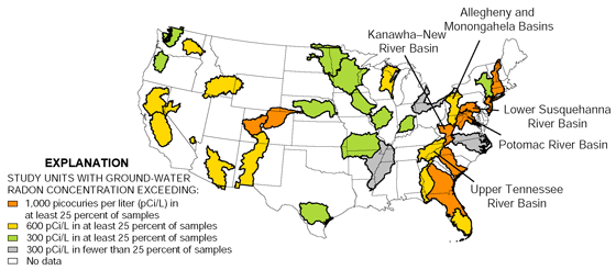
Radon is a radioactive gas that forms during the decay of natural uranium. Igneous and metamorphic rocks, like those in the Blue Ridge, commonly contain more uranium than other rock types. Radon in the air in homes is the second leading cause of lung cancer; and radon causes 23 percent of all cancer deaths in the United States. Homes can be designed or remodeled to remove radon from both drinking water and interior air. The only way to determine if an individual well or home exceeds standards, however, is to have the water or air tested. Information on radon testing and removal is available at http://www.epa.gov/safewater/radon/qa1.html and other Web sites. Radon concentration exceeds 1,000 pCi/L (picocuries per liter) in at least 25 percent of ground-water samples collected in many areas of the Eastern United States. In the KanawhaNew River Basin, 30 percent of samples exceeded 1,000 pCi/L (Appendix, p. 27), making the basin comparable to the Potomac and Lower Susquehanna River Basins to the northeast. Within the basin, however, radon in two-thirds of samples from wells in the Blue Ridge exceeded 1,000 pCi/L, but only in 10 percent of samples from the Appalachian Plateaus. The northern part of the basin, therefore, is more comparable to the adjacent Allegheny and Monongahela Rivers and Upper Tennessee River Basins. |

Ground-water Radon Concentrations were Highest in the Blue Ridge
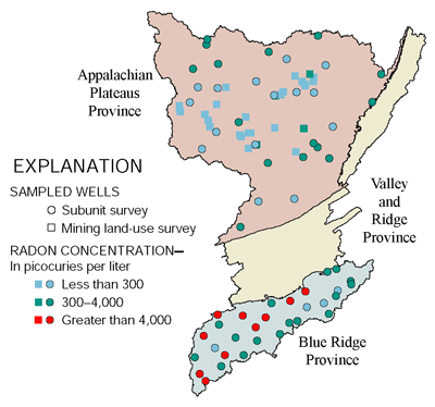 |
| Figure 21. Radon concentrations vary greatly among physiographic provinces. |
Radon concentrations were greater than 300 pCi/L, the proposed drinking-water standard (U.S. Environmental Protection Agency, 1999), in 87 percent of wells sampled in the Blue Ridge (fig. 21). The maximum concentration detected was 30,900 pCi/L (Kozar and Sheets, 1997). Of the 30 wells sampled, 10 contained concentrations of radon greater than 4,000 pCi/L, the alternate standard USEPA has proposed for regions where action is taken to decrease airborne radon. As water is used in a home, radon in the water can lead to an increase in radon in the air, which is the major exposure path for people.
Radon concentrations exceeded 300 pCi/L at 50 percent of wells sampled throughout the Appalachian Plateaus. The maximum in any sample was 2,500 pCi/L (fig. 21). The area is underlain primarily by sandstone, shale, coal, and limestone sedimentary rocks, in which uranium is less common than in igneous and metamorphic rocks.
At 28 wells downgradient from recently reclaimed surface coal mines, the median radon concentration was just 115 pCi/L, and the maximum was 450 pCi/L. In comparison, at 15 wells in the same geologic units but not near mines, the median concentration was 200 pCi/L.
Modern Well Construction Can Prevent Fecal Bacteria from Reaching Drinking Water in Most Areas
Escherichia coli (E. coli) and the broader fecal coliform group of bacteria indicate the possible presence of disease-causing organisms. Standards for public drinking-water supplies do not permit the presence of any of these bacteria at detectable levels. Septic systems or livestock near a well are the probable sources of bacteria throughout the basin. Proper well construction can prevent bacteria from reaching the well water in some settings, and drinking water can be disinfected with chemicals or ultraviolet light.
Water from wells less than 25 years old in the Appalachian Plateaus and Blue Ridge was generally free from fecal bacteria (table 2). The sampled wells were generally in good condition, with a section of solid pipe at the top of the well sealed with concrete into the soil and rock (Sheets and Kozar, 1997). A residential septic system typically was nearby, but no heavy livestock use was within several hundred yards. Bacteria were found, however, at one fourth of the wells in a second study in the Appalachian Plateaus, which included some older wells and some without seals. Near these wells, there also may have been bacteria sources other than a septic system.
|
||||||||
Most wells in limestone aquifers in the basin, including the Valley and Ridge, are at risk of contamination by bacteria (Boyer and Pasquarell, 1999), even if septic systems or livestock wastes are not nearby (Mathes, 2000), because ground water moves rapidly through solution channels in the rock. The wide valleys that typically overlie limestone aquifers are heavily used for livestock and agriculture.
Volatile Organic Compounds and Pesticides in Ground Water were Found in Low Concentrations
Both volatile organic compounds (VOCs) and pesticides were detected at low concentrations in the ground water of the KanawhaNew River Basin (Appendix, p. 27). Thirteen percent of samples (9 of 60) contained VOC concentrations greater than 0.1 µg/L. Of the seven detected VOCs, however, only three have established drinking-water standards. None of the VOCs identified in samples exceeded these standards. Pesticides were found above a detection limit of 0.001 µg/L in 32 percent of samples (19 of 60). Of the 12 detected pesticides, 4 have established drinking-water standards, none of which was exceeded.
Pesticides were detected in 17 of 30 wells sampled in the Blue Ridge, where 30 percent of the land was being used for agriculture in 1993. The most commonly detected pesticides, at one-third of the wells, were atrazine and its breakdown product deethylatrazine. The maximum concentration of all pesticides detected in a single sample was 0.14 µg/L. Two other pesticides, p,p'-DDE and simazine, were present in more than 10 percent of samples at a maximum concentration of 0.025 µg/L in this province. In the largely non agricultural Appalachian Plateaus, however, pesticides were detected only at two wells.
Nutrient Concentrations in Ground Water were At or Below National Background Levels
Nutrients were prevalent at relatively low concentrations in ground water of the KanawhaNew River Basin. Nitrate concentration in 1 of 88 wells sampled in this study exceeded the USEPA drinking-water standard of 10 mg/L (as nitrogen). Most ground water contained less nitrate than does precipitation in the basin. Concentrations of other nutrients measured were at or below national background levels. These findings are consistent with national findings on nutrients in the ground water of forested areas, and the Kanawha-New River Basin is about 80 percent forested.
In the water of Appalachian Plateaus wells, the relatively high median ammonia concentration for a forested region0.16 mg/L is probably a result of mineralization of organic material. In contrast, ground water in the Blue Ridge, where a greater percentage of land is used for agriculture, had ground water with a higher median nitrate concentration (0.42 mg/L) and a higher median dissolved-oxygen concentration (5.1 mg/L).
| Table of Contents || Previous Section || Next Section || Glossary U.S. Geological Survey Circular 1204 Suggested citation:
|
