
STUDY UNIT DESIGN
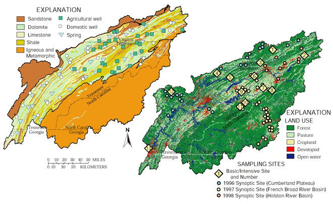
Study designs for both ground-water and surface-water components focused principally on the Valley and Ridge province. The Valley and Ridge is home to the majority of the Study Unit population and is the most highly developed in terms of agriculture and urban land uses. Ground-water studies focused on the carbonate-based dolomites and limestones of the Valley and Ridge. These geologic units form the most prolific aquifers in the Upper Tennessee River Basin and also are the most susceptible to contamination because of their associated karst and solution features. Ground-water resources are very limited in the Blue Ridge and Cumberland Plateau provinces because of the relatively impermeable nature of the bedrock and the low water-storage capacity of the thin soils that overlie the bedrock.
Surface-water studies focused on the unregulated portions
of the Upper Tennessee River Basin principally in the Valley and Ridge
province, which contains the most intense agricultural activity in the
basin. Thirteen basic fixed stream-sampling sites were operated during
the study to monitor water-quality conditions with time in various parts
of the basin. Data-collection sites were selected to cover the major subbasins
of the Upper Tennessee River and to encompass the major land uses. An
additional 61 sites were sampled during the study as part of three synoptic
networks designed to better describe areal water-quality variations of
the subbasins. In keeping with the NAWQA multiple lines of evidence approach
to describe water-quality conditions,(34) data- collection
activities included water-column chemistry at all sites, bed-sediment
and Asiatic clam tissue samples at Basic Fixed Sites, and stream ecological
sampling (fish communities, benthic invertebrates, habitat, and algae)
at all Basic Fixed Sites and most Synoptic sites.
 |
|
Site |
Site name |
Site type |
Physio- |
|---|---|---|---|
| 1 |
Guest River near Millers Yard, Virginia |
Indicator, Mining |
CP |
| 2 |
Middle Fork Holston River at Seven-Mile Ford, Virginia |
Indicator, Mixed |
VR |
| 3 |
Copper Creek near Gate City, Virginia |
Indicator, Agriculture |
VR |
| 4 |
Powell River near Arthur, Tennessee |
Integrator |
CP-VR |
| 5 |
Clinch River at Tazewell, Tennessee |
Integrator |
VR-CP |
| 6 |
Holston River at Surgoinsville, Tennessee |
Integrator |
VR |
| 7 |
Big Limestone Creek near Limestone, Tennessee |
Indicator, Agriculture |
VR |
| 8 |
Nolichucky River at Embreeville, Tennessee |
Indicator, Mining |
BR |
| 9 |
Nolichucky River at Lowlands, Tennessee |
Indicator, Mixed |
BR-VR |
10 |
French Broad River near Newport, Tennessee |
Indicator, Agriculture |
BR |
| 11 |
Pigeon River at Newport, Tennessee |
Integrator |
BR-VR |
| 12 |
Clear Creek at Lilly Bridge, Tennessee |
Integrator |
CP |
| 13 |
Tennessee River at Chattanooga, Tennessee |
Integrator |
CP-VR-BR |
|
* CP- Cumberland Plateau, BR - Blue Ridge, VR - Valley and Ridge |
|||
SUMMARY OF DATA COLLECTION IN THE UPPER TENNESSEE RIVER BASIN, 1994-98
| Study |
What data were collected and why |
Types of sites sampled |
Number of sites |
Sampling
frequency |
|---|---|---|---|---|
| Stream Chemistry |
||||
| Bottom- |
Sediment in depositional zones was sampled for pesticides, other synthetic organic compounds, and trace elements to determine the presence of potentially toxic compounds. Water-quality samples also were taken at each site, including major ions, nutrients, organic carbon, pesticides, bacteria, and suspended sediment. |
Selected rivers and streams. |
15 |
Once |
| Water-
|
Water-chemistry data, including major ions, nutrients, organic carbon, pesticides, bacteria, and suspended sediment, were used to describe concentrations and loads. |
Sampling occurred near selected continuous streamflow sites. |
13 |
Variable |
| Storm
|
Water-chemistry data, including major ions, nutrients, organic carbon, pesticides, bacteria, and suspended sediment, were used to describe concentrations and loads. |
Samples were taken at water- chemistry sites during high-flow conditions. |
Variable |
Variable |
| Nutrient/ |
Water-chemistry data, including major ions, nutrients, organic carbon, pesticides, bacteria, and suspended sediment, were used to describe concentrations of selected constituents. |
Surface-water sampling sites in the Cumberland Plateau, French Broad River Basin, and the Valley and Ridge were selected to describe conditions across the Study Unit. |
64 |
Variable |
| Intensive
|
Pesticides, major ions, organic carbon, suspended sediment, bacteria, and nutrients were analyzed to determine seasonal variations in concentrations and loads. |
Water-chemistry sites located in intensive agricultural basins or mixed land-use basins. |
3 |
Biweekly |
| Stream Ecology |
||||
| Contaminants |
Asiatic clams were sampled for pesticides, other synthetic organic compounds, and trace elements to determine the presence of potentially toxic compounds. |
Selected rivers and streams. |
15 |
Once |
| Aquatic |
Biological communities and stream habitat were assessed and fish, macroinvertebrates, and algae were quantitatively sampled. |
Biological communities and habitat at basic fixed water-chemistry sites, and biological communities at synoptic sites. |
13 fixed sites, 63 synoptic sites |
Once |
| Spring |
Macroinvertebrates were qualitatively sampled. |
Spring sites. |
35 |
Once |
| Ground-Water Chemistry |
||||
| Agricultural |
Water-chemistry data, including major ions, nutrients, organic carbon, pesticides, and radon, were analyzed to determine the effects of burley tobacco production on shallow ground-water quality. |
Shallow 2-inch monitoring wells were installed adjacent to tobacco fields in the Valley and Ridge in northeastern Tennessee and southwestern Virginia. |
30 |
Once |
| Study Unit | |
Water-chemistry data, including major ions, nutrients, organic carbon, pesticides, bacteria, and radon were analyzed to determine the quality of ground water. |
Randomly selected springs in the Valley and Ridge. |
35 springs |
Once |
| Study Unit |
Water-chemistry data, including major ions, nutrients, organic carbon, pesticides, bacteria, and radon, were analyzed to determine the quality of ground water. |
Randomly selected wells in the Valley and Ridge. |
30 wells |
Once |
| Table of Contents || Previous Section || Next Section || Glossary U.S. Geological Survey Circular 1205 Suggested citation:
|
