
MAJOR FINDINGS
Nutrient Contributions to the Mississippi River System
 |
| The Yazoo River, the river with the largest drainage area wholly contained in the Mississippi Embayment Study Unit, enters the Mississippi River just north of these bridges at Vicksburg, Mississippi. |
Although nitrogen and phosphorus, as well as silica and other nutrients, are natural and important parts of a healthy ecosystem, severe water-quality problems can arise if an ecosystem becomes enriched, or overloaded, with nutrients. In recent years, scientists have become aware of a large area of low dissolved oxygen that develops off the coast of Louisiana and Texas each summer. The extent and duration of this area of low dissolved oxygen has been related to the amount of nutrients, especially nitrogen, and freshwater flowing from the Mississippi River into the Gulf of Mexico (Goolsby and others, 1999). The proximity of the MISE Study Unit to the Gulf and the use of nitrogen fertilizer in the agricultural areas of the Study Unit, especially the Yazoo River Basin, have led to speculation that the surface waters of the Study Unit may be contributing a disproportionate amount of nitrogen and phosphorus to the Mississippi River and ultimately to the Gulf of Mexico.
In the MISE Study Unit investigations have shown that concentrations of nutrients (except total phosphorus) are higher in the Mississippi River at Vicksburg, Mississippi than near the mouth of the Yazoo River (table 1). The annual load of nitrogen and phosphorus from the Yazoo River for the 199697 calendar years, while significant, was only a small percentage of the load carried by the Mississippi River (Coupe, 1998).
| Table 1. Concentrations of nutrients near the mouth of the Yazoo River compared to the Mississippi River at Vicksburg, Mississippi. [Concentrations are in milligrams per liter] |
|||||
| Constituent |
Site |
Year |
Maximum |
Minimum |
Mean |
|---|---|---|---|---|---|
| Total nitrogen | Yazoo River | 1996-97 |
3.3 |
0.57 |
1.3 |
| Mississippi River | 1984-93 |
3.8 |
1.1 |
2.3 |
|
| Nitrate as N | Yazoo River | 1996-97 |
1.2 |
0.16 |
0.45 |
| Mississippi River | 1984-93 |
2.7 |
0.70 |
1.5 |
|
| Total phosphorus | Yazoo River | 1996-97 |
0.89 |
0.12 |
0.26 |
| Mississippi River | 1984-93 |
0.38 |
0.04 |
0.16 |
|
| Orthophosphate as P | Yazoo River | 1996-97 |
0.10 |
0.01 |
0.043 |
| Mississippi River | 1984-93 |
0.13 |
0.02 |
0.058 |
|
Water-Quality Standards
Concentrations of nitrogen and phosphorus were measured from weekly to at least monthly at nine stream-sampling sites in the MISE Study Unit. Nitrate concentrations never exceeded the drinking-water standard of 10 mg/L in any sample, and ammonia concentrations did not exceed aquatic-life guidelines. However, the USEPA goal of 0.1 mg/L or less total phosphorus for streams not entering reservoirs was exceeded in every sample from the urban stream and in more than 50 percent of the samples from five streams located in the Mississippi Alluvial Plain. Samples from the streams located in the Gulf Plains exceeded the recommended goal of 0.1 mg/L or less total phosphorus in less than 50 percent of the samples.
Comparison of Nitrogen and Phosphorus in Streams in the Mississippi River Basin
The yield of nitrogen (mass per unit area), from streams in the MISE Study Unit during 199596 was compared to the average yield during 198096 from streams in the Mississippi River Basin. These data indicate that the yield of nitrogen from the MISE Study Unit was less than the average yield from streams in intensive agricultural areas of the Midwest, but more than from streams in the drier West or in the less agricultural Upper Mississippi River Basin. The flow-weighted mean total nitrogen concentrations for streams in the MISE Study Unit were generally in the 50th to 60th percentile for all data collected in the national NAWQA Program (372 steam sites). The exception was the mean nitrogen concentration at the smallest mixed land-use site which was near the 20th percentile, nationally.
The yields of total phosphorus generally were higher in the MISE Study Unit than from most other areas in the Mississippi River Basin, and the percentile ranking of the flow-weighted mean total phosphorus concentration generally was quite high (67th to 93d). Again, the exception was the smallest mixed land-use site, where the mean total phosphorus concentration was near the 40th percentile. These high phosphorus yields were somewhat unexpected, as the soils in the MISE Study Unit, while fertile, do not contain excessive amounts of phosphorus. Also, phosphorus is used less as a fertilizer in the MISE Study Unit than in many parts of the Midwest (Battaglin and Goolsby, 1995), and due to the rural nature of the MISE, there are few significant point sources. One hypothesis for the high yields and concentrations of phosphorus in the MISE involves a combination of factors, such as soils, rainfall, and agricultural drainage. The sediment in the rivers of the MISE Study Unit is composed of fine, clay-sized particles to which phosphorus can sorb. Heavy rainfalls in the Study Unit increase the potential for erosion and the movement of these fine clay-sized particles from agricultural fields into the streams. Additionally, because of the large amount of rain, the tight clays that decrease infiltration of water, and the relatively flat terrain, much of the Study Unit has artificial drainage to expedite the movement of water. Most of this artificial drainage is surface drainage, which has been shown to decrease nitrate concentrations but to increase total phosphorus concentrations.
The Effects of Land Use and Geology on Nutrient Concentrations and Yields
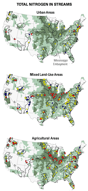
Generally, total nitrogen and phosphorus concentrations and yields were higher in streams with predominantly agricultural land use in the Mississippi Alluvial Plain, but the highest nutrient concentrations and yields were from the urban stream. However, one stream located in the Gulf Plains in an area with no urban land use and only a moderate amount of agricultural land use had comparatively high total nitrogen and phosphorus yields. The high yields in this stream are reflective of the steep topography of the area and channelization of the stream for flood-control purposes.
|

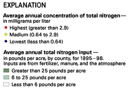
| Nutrient Yields from MISE Watersheds |
|
Phosphorus yields from watersheds within the MISE Study Unit were the highest in the Mississippi River Basin (represented by the dark green bars). These high phosphorus yields probably are related to several factors such as soils, amounts of rainfall, and artificial drainage of agricultural fields. In contrast, total nitrogen yields in streams in the Mississippi Embayment were less than those from the agriculturally productive Midwest, but more than those in the drier western part of the basin or the cooler Upper Mississippi River Basin, and about the same as streams in the Ohio River Basin. (Data from Goolsby and others, 1999.) |
| More details on nutrients in the Yazoo River can be found in the report: Coupe, R.H., 1998, Concentrations and loads of nitrogen and phosphorus in the Yazoo River, northwestern Mississippi, 199697: U.S. Geological Survey Water-Resources Investigations Report 984219, 17 p. The report also can be downloaded at: http://ms.water.usgs.gov/nawqa/ |
Pesticides Commonly Found in Mississippi Embayment Surface Water
 |
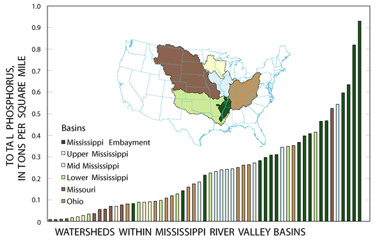
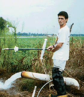
| Water samples are filtered and processed in a mobile laboratory immediately after sample collection. |
The occurrence and temporal distribution of more than 80 pesticides and pesticide metabolites were determined at five stream-sampling sites from 1996 to 1998 in the MISE Study Unit. More than 230 stream samples were collected and analyzed. The five rivers sampled included three rivers with small, primarily agricultural watersheds; one river with a small, urban watershed; and one large river (the Yazoo River) with mixed land use (row-crop agriculture, forest, pasture, and a small amount of urban). Pesticides, usually herbicides, frequently were detected in water samples from all five rivers sampled. Aquatic-life guidelines were frequently exceeded in the urban stream and occasionally exceeded in all of the rivers sampled in the MISE Study Unit.
Agricultural Streams
The pesticides detected in the rivers that drain the agricultural watersheds in the MISE Study Unit showed distinct seasonal patterns that corresponded to the type of crops grown in the basin and the use of pesticides on those crops. For instance, the highest concentration of the pre-emergent herbicide atrazine frequently was found early in the growing season (April-May) corresponding to its application prior to the planting of corn and grain sorghum (fig. 6). The highest concentrations of herbicides that are used on other crops (cotton and rice) with later planting dates, or herbicides that are used after the crop has emerged from the ground, such as fluometuron and molinate, were detected later in the growing season (JuneJuly). The concentrations of most of these herbicides were well below any acute toxicity; however, the long-term effects of chronic exposure to low levels of multiple herbicides are not well known.
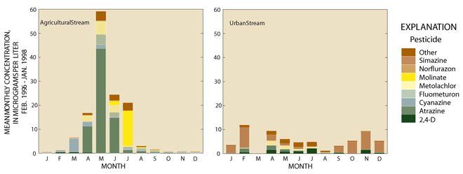 |
| Figure 6. Herbicides in agricultural streams in the Mississippi Embayment Study Unit had higher concentrations, showed clear seasonal patterns, and contained different compounds than herbicides in urban streams. The urban stream samples were dominated by simazine, a turf grass herbicide. Concentrations of herbicides in the urban stream remained fairly constant throughout the year, whereas agricultural sites had concentrations that peaked in the spring shortly after application. Agricultural sites also were dominated by different herbicides (in this case atrazine). |
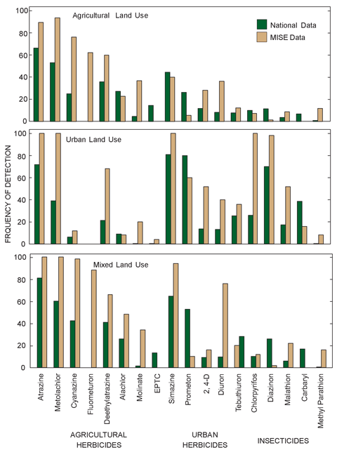
This diagram shows the top 15 pesticides most frequently detected in surface water at NAWQA Study Units throughout the United States and detections in surface water of the Mississippi Embayment (MISE Study Unit). Three pesticides used heavily in the Study Unitfluometuron, methyl parathion, and molinatebut not used extensively throughout the United States, also are included for comparison. Few areas of the United States are as suited to agriculture as the Mississippi River Alluvial Plain in the MISE Study Unit. The combination of rich alluvial soils; a long, hot, growing season; flat terrain; and plentiful rainfall make agriculture the dominant economic force in the Study Unit. These same conditions also increase the weed and insect pressure and subsequently lead to an intensive use of pesticides to encourage profitable farming. In general, the frequency of detection of pesticides in surface waters of the MISE Study Unit exceed the national average. |
Urban Stream
 |
| Many pesticides are applied by aircraft in the Study Unit. |
The type, amounts, and timing of the occurrence of pesticides in the stream draining an urban watershed are much different from those in the agricultural streams (fig. 6). The herbicides most frequently occurring in the urban stream such as atrazine, 2,4D, simazine, and prometon, are those used in lawn care and in the maintenance of rights-of-way. The urban stream was also the only stream with frequent occurrences of insecticides: chlorpyrifos and diazinon were detected in every urban stream sample collected and exceeded the aquatic-life guidelines in 12 of 25 and 24 of 25 samples, respectively.
DDT Metabolites in Surface Water
Although DDT strongly sorbs to sediments rather than readily dissolving in water, detectable levels of DDE, a metabolite of DDT, were found in 14 percent of the filtered stream-water samples analyzed.
| More details on pesticides in streams in the MISE can be found in the report: Coupe, R.H., 2000, Occurrence of pesticides in five rivers of the Mississippi Embayment Study Unit, 199698: U.S. Geological Survey Water-Resources Investigations Report 994159, 69 p. The report also can be downloaded at: http://ms.water.usgs.gov/nawqa/ |
 |
|
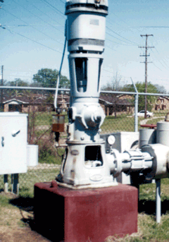
| Ground-water samples commonly were collected from municipal drinking-water facilities, such as the one pictured above. |
Tertiary Aquifers Have High-Quality Drinking Water
During the spring of 1996, water samples were collected from 30 public-supply wells in the deep Tertiary aquifers in the MISE Study Unit. The most significant finding from this part of the study is that all of the samples analyzed from these public-supply wells met all existing drinking-water standards and guidelines. Concentrations of most of the constituents measured that could adversely affect water quality, including nutrients, pesticides, radon, and volatile organic compounds, were below drinking-water standards and guidelines.
The Deep Tertiary Aquifers
The deep Tertiary aquifers underlie about 80 percent of the MISE Study Unit. Much of the population in this part of the country depends on these aquifers for drinking water. Wells sampled range in depth from 208 to 1,460 feet below the ground surface.
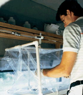 |
| Ground-water sample preparation occurred inside plastic enclosures in order to minimize sample contamination from chemicals in the atmosphere. |
Sample Results
Water from wells in the deep Tertiary aquifers had low nutrient concentrations. The highest nutrient concentration measured in a sample was 3.8 mg/L of nitrite plus nitrate nitrogen, which is less than half the drinking-water guideline of 10 mg/L. Pesticides were detected in water from only one of the wells. Water from the shallowest well sampled had a 0.16-µg/L (microgram per liter) concentration of the herbicide bromacil and a 0.004- µg/L concentration of deethylatrazine, a metabolite of the herbicide atrazine. Volatile organic compounds (VOCs) are compounds that have a high vapor pressure relative to their water solubility and include such things as components of gasoline and organic solvents. VOCs were detected frequently in the MISE, but concentrations were far below drinking-water guidelines. Samples from 26 of the 30 public-supply wells had at least one VOC detection. The VOCs most commonly detected were methylethylketone and 1,2,4-trimethylbenzene, detected in 23 and 7 percent of the wells, respectively. Nutrients, pesticides, and VOCs generally enter the ground water from surface contamination; however, public-supply wells were generally deep enough to avoid elevated levels of these compounds.
Radon in water from the public-supply wells ranged from 54 to 270 picocuries per liter; none exceeded guidelines. Radon levels found in the ground water in the MISE were the second lowest of the 16 Study Units sampled during 199698.
Few Pesticides Detected in Memphis Shallow Aquifers
In addition to the Tertiary aquifers, 32 shallow monitoring wells (not public-supply, drinking-water wells) were sampled in the shallow aquifers near Memphis, Tennessee. Results were similar to those from the deep Tertiary aquifer study except that pesticides were more frequently detected and radon concentrations were higher. An atrazine concentration of 3.14 µg/L was measured in one well, which narrowly exceeded the drinking-water guideline of 3.0 µg/L, and dieldrin was measured above the drinking-water guideline of 0.02 µg/L in another well.
| More details on ground-water quality in the deep Tertiary aquifers can be found in the report: Gonthier, G.J., 2000, Water quality in the deep Tertiary aquifers of the Mississippi Embayment, 1996: U.S. Geological Survey Water-Resources Investigations Report 994131, 91 p. The report also can be downloaded at: http://ms.water.usgs.gov/nawqa/ |
Water-Quality Differences in Geological Subunits of the Alluvial Aquifer
 |
| Many of the water samples collected from the alluvial aquifer were taken from irrigation wells in agricultural areas. |
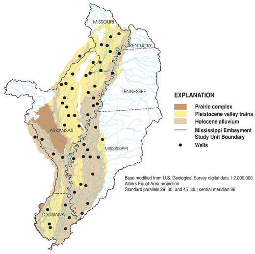
Previous researchers have studied the alluvial aquifer as a single Quaternary feature (Grubb, 1986; Ackerman, 1989). However, during this NAWQA investigation, the results of the water-chemistry studies were examined by dividing the area into different major geologic units, two of which are the Pleistocene valley trains and the Holocene alluvium (Saucier, 1994). The data collected suggest that the differences in the geology influence the chemical makeup of the ground water in the alluvial aquifer.
The Alluvial Aquifer
The alluvial aquifer is a large, underground, water-bearing layer of sand and gravel in the Lower Mississippi River Valley (fig. 7). Water use from the alluvial aquifer is enormous; pumpage from the aquifer is about 7 billion gallons per day (Mesko and others, 1990). Most of the water pumped from the alluvial aquifer is used to irrigate crops or to maintain aquaculture, but the ground water also is used for public supply and industry.
Water-Chemistry Analysis Results
Twenty-nine wells in the Pleistocene valley trains and 25 wells in the Holocene alluvium were sampled during the summer of 1998. At least one pesticide was detected in water from 19 of the 54 wells, but none of the concentrations were above drinking-water standards or guidelines. The most frequently detected pesticide was bentazon, an herbicide used to control weeds in soybean fields. Other pesticides detected in the alluvial aquifer in very low concentrations were molinate, fluometuron, 2,4D, fenuron, atrazine, deethylatrazine, metolachlor, propanil, and p,p´ DDE. At least one VOC was detected in water from 25 of 46 wells; 1,2,4-trimethylbenzene was detected most frequently. However, all of the VOC concentrations were well below drinking-water standards or guidelines.
Pleistocene Valley Trains and the Holocene Alluvium
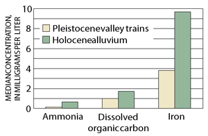 |
| Figure 8. This graph shows some of the differences in chemistry in water from the Pleistocene valley trains and from the Holocene alluvium for a few selected constituents. Water from the wells in the Holocene deposits tended to be older and had lower oxygen levels. Low dissolved-oxygen concentrations in ground water may be associated with the presence of ammonia, dissolved organic carbon, and iron. |
The two subunits of the alluvial aquifer, the Pleistocene valley trains and the Holocene alluvium, have different lithological characteristics. The Pleistocene valley trains generally have coarser grain sizes than the Holocene alluvium, whereas the Holocene alluvium has a thicker clay and silt surficial unit. These characteristics indicate that ground-water flow may be more active in the Pleistocene valley trains.
Results of the ground-water chemistry showed that sulfate, pH, tritium, chloride, and radon-222 were present in higher concentrations in water from wells in the Pleistocene valley trains, whereas dissolved organic carbon, iron, ammonia, fluoride, potassium, bicarbonate, magnesium, radium-226, barium, calcium, chromium, and dissolved solids were present in higher concentrations in water from wells in the Holocene alluvium. Examples of some of these differences are shown in figure 8. Water in the Holocene alluvium tends to be older than water in the Pleistocene valley trains; that is, it has been underground longer. This increases possible contact with buried organics, resulting in less dissolved oxygen, which could influence concentrations of other chemical constituents.
Arsenic Concentrations
Arsenic, a compound that has been implicated in causing several cancers, was found at concentrations that exceeded current drinking-water guidelines in water from only one irrigation well that pumped water from the alluvial aquifer. However, concentrations at several other wells were high enough to justify additional testing if proposals to lower the standards are promulgated.
|
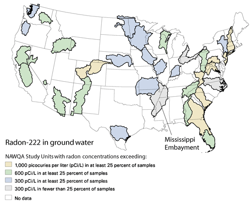
Radon is a colorless, odorless, radioactive gas that forms naturally in rocks and soils as an intermediate product in the radioactive decay of uranium-238. According to the U.S. Environmental Protection Agency, breathing radon in indoor air is the second leading cause of lung cancer in the United States. Radon can enter homes from soil or bedrock through cracks in basements or foundations, or it can be released from water during bathing, cooking, or showering. Radon is highest in areas where there are uranium-rich metamorphic and igneous rocks. Because the MISE Study Unit is located in an area of thick alluvial soils that have few rocks, the radon levels in the ground water are some of the lowest reported by the NAWQA Program.
|

| Table of Contents || Previous Section || Next Section || Glossary U.S. Geological Survey Circular 1208 Suggested citation:
|