
INTRODUCTION TO THE UPPER MISSISSIPPI RIVER BASIN
The Upper Mississippi River Basin Study Unit (Study Unit) includes the drainage of the Mississippi River from its source at Lake Itasca, Minnesota, and its major tributaries (the St. Croix and Minnesota Rivers) to the outflow of Lake Pepin, Minnesota (fig. 1). Natural and human factors (climate, hydrology, geology, water use, land use, and land cover) affect surface- and ground-water quality, and aquatic biology in rivers and streams.
Natural Factors Affect Water Quality and Aquatic Biology
Differences in precipitation, evaporation, evapotranspiration, air temperature (fig. 1), and drainage basin characteristics (drainage area, slope, geology, and the capacity of soils to transmit water) affect hydrology and water quality. These differ most from southwest to northeast. Mean annual runoff, which is related to precipitation and evaporation, ranges from less than 2 inches in the headwaters of the Minnesota River to greater than 14 inches in the headwaters of the St. Croix River.
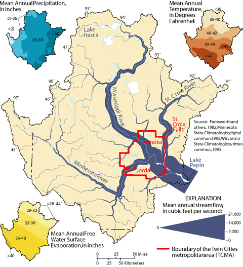 |
| Figure 1. Climatic variables such as precipitation, temperature, and evaporation affected streamflow in the Study Unit, 1961-90. |
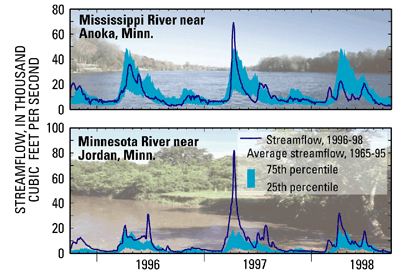 |
| Figure 2. Streamflow during the sampling period (1996-98) in the large rivers in the Study Unit differed from their 30-year average, 1965-95. |
The range from minimum to maximum streamflow is greatest in spring and early summer as a result of rain and melting snow. Streamflow variation is greatest during late summer and fall, when precipitation ranges from drought conditions to locally heavy rains (fig. 2). Streamflow varies least during winter, when ground-water discharge to streams is dominant. During the period of sampling (199698), precipitation was greater than the 30-year average, resulting in increased runoff and streamflow. As a result, the amount of sediment, nutrients, pesticides, and other contaminants reaching streams may have been greater than during periods of normal streamflow.
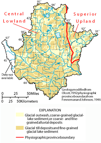 |
| Figure 3. Surficial geology and physiographic provinces can affect water quality in the Study Unit. |
Water quality is also affected by geologic materials. Most streams in the Study Unit drain the Central Lowland physiographic province, which is underlain by clay-rich, calcareous (calcium carbonate) glacial deposits (fig. 3). Fewer streams drain the Superior Upland physiographic province, which is primarily underlain by siliceous (rich in silica), sandy glacial deposits. Water in streams draining the Central Lowland generally has greater alkalinity and greater concentrations of suspended sediment than water in streams draining the Superior Upland.
Human Activities Affect Water Quality and Aquatic Biology
The greatest effects on hydrology, water quality, and aquatic biology occur in areas with the greatest human population densities or where disruption to the natural land cover is substantial. The population of the Study Unit in 1990 was about 3.7 million16-percent increase from 1970. Seventy-five percent of those people reside in the TCMA.
Land use and land cover in the Study Unit can be categorized into three zones: an agricultural zone across the southwest, a forested zone across the northeast, and a transitional zone between these areas (fig. 4). About 63 percent of the Study Unit is agricultural (cropland and pasture). The remaining land use and land cover consists of forests (about 22 percent), water and wetlands (about 13 percent), urban (about 2 percent), and other categories (less than 1 percent).
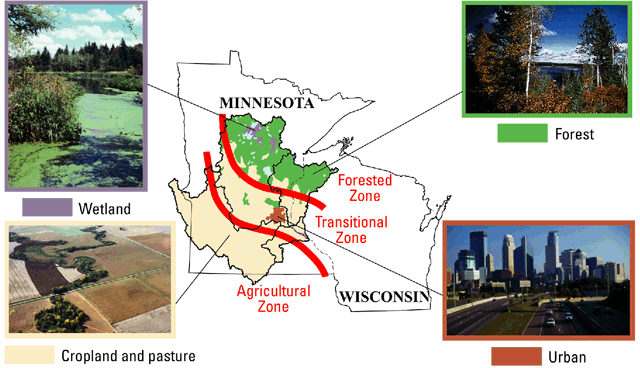 |
| Figure 4. Land use and land cover can be categorized into three general zones in the Study Unit. |
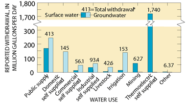 |
| Figure 5. Ground water supplies the majority of the public drinking water in the Study Unit in 1990. (* Total refers to the combination of surface and ground water in each category.) |
The uses of water and the disposal of wastewater also can affect water quality and streamflow. Based on data from 1990, a daily average of 413 Mgal/d (million gallons of water per day) was used for public supply (including drinking water) in the Study Unit59 percent from ground water and 41 percent from surface water (fig. 5). The total of all water used for public supply is equal to about 7 percent of the average streamflow of the Mississippi River upstream from the TCMA, near Anoka, Minn. Wastewater is discharged to streams from about 270 facilities located throughout the Study Unit (Kroening and Andrews, 1997).
| Table of Contents || Previous Section || Next Section || Glossary U.S. Geological Survey Circular 1211 Suggested citation:
|
