
STUDY UNIT DESIGN
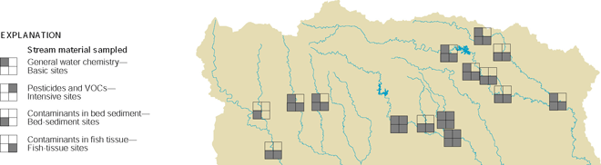 |
Stream ChemistryBasic and intensive sites were selected primarily to assess the occurrence and distribution of dissolved compounds in stream water. Basic sites were sampled less frequently and for fewer compounds than intensive sites. Intensive sites were sampled to evaluate the seasonal effects of land use on water quality and to determine the occurrence of pesticides and VOCs. Sampling of streambed sediments and fish tissue was done to assess the occurrence and distribution of organic compounds and trace elements.
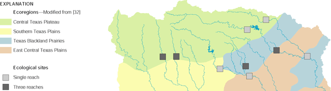 |
Stream EcologyThe primary objective of the stream ecology component was to assess surface-water quality by integrating physical, chemical, and biological factors. Therefore, the ecological sites were primarily the same as the basic sites. Ecological sites, some with one reach and some with three reaches, were distributed among different land uses and ecological regions.
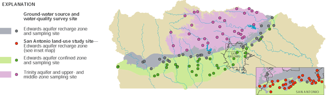 |
Ground-Water ChemistryAquifer surveys were done to provide a broad assessment of water quality in the Edwards aquifer (recharge and confined zones) and the Trinity aquifer (upper and middle zones). The aquifer surveys involved sampling primarily existing domestic and public-supply wells. The primary objective of the land-use study was to characterize the effects of urban land use on the quality of recently recharged ground water in the Edwards aquifer. A second objective was to learn more about the human and natural factors that affect ground-water quality.
|
Study |
What data were collected and why |
Types of sites sampled |
Number |
Sampling frequency |
|---|---|---|---|---|
| Stream Chemistry |
||||
| Basic sites--General water chemistry |
Streamflow, field parameters,1 major ions, nutrients, organic carbon, and suspended sediment to determine concentrations and seasonal variations |
Streams draining basins ranging in size from 130 to 3,500 square miles and representing urban, agricultural, and rangeland use |
9 |
Monthly plus storms; April 1996-June 1998 |
| Intensive sites--Pesticides and VOCs |
Constituents for basic sites plus 83 pesticides and 86 VOCs to determine concentrations and seasonal variations |
A subset of basic sites draining urban and agricultural land-use areas |
3 |
Weekly to monthly plus storms; January 1997-March 1998 |
| Bed-sediment sites--Contaminants in bed sediment |
Total PCBs, 32 organochlorine pesticides, 63 SVOCs, and 44 trace elements to determine occurrence and spatial distribution |
Depositional zones of all basic and intensive sites, and six additional similar sites for increased spatial distribution |
15 |
Once; August 19952, November 1996, November 1997, or February 1998 |
| Fish-tissue sites--Contaminants in fish tissue |
Total PCBs, 27 organochlorine pesticides, and 22 trace elements in fish and clam tissue to determine occurrence |
All basic and intensive sites, and five additional similar sites for increased spatial distribution |
14 |
Once at 8 sites, 2-3 times at 6 sites; selected months August 19952-February 1998 |
| Stream Ecology |
||||
| Single-reach assessment |
Fish, macroinvertebrates, algae, and aquatic and riparian habitat surveys to assess ecological conditions at a single stream reach |
Stream reaches collocated with basic sites draining urban, agricultural, and rangeland areas |
9 |
Yearly for 3 years; July-August 1996, 1997, 1998 |
| Multiple-reach assessment |
Fish, macroinvertebrates, algae, and aquatic and riparian habitat surveys to assess ecological conditions at three stream reaches |
Stream reaches collocated with a subset of basic sites draining urban, agricultural, and rangeland areas |
4 |
Once; July-August 1996 |
| Ground-Water Chemistry |
||||
| Aquifer survey--Edwards aquifer recharge zone |
Field parameters,1 turbidity, major ions, nutrients, organic carbon, trace elements, 83 pesticides, 86 VOCs, radon, and tritium to describe the spatial distribution of ground-water quality |
Primarily existing open-hole domestic wells less than 600 feet deep, selected using a statistically based random process |
28 |
Once; June-August 1996 |
| Aquifer survey-- Edwards aquifer confined zone |
Field parameters,1 turbidity, major ions, nutrients, organic carbon, trace elements, 47 pesticides, 86 VOCs, radon, and tritium to describe the spatial distribution of ground-water quality |
Primarily existing open-hole public-supply wells 400-2,700 feet deep, selected using a statistically based random process |
30 |
Once; June-August 1997 |
| Aquifer survey--Trinity aquifer upper and middle zones (undifferentiated) |
Field parameters,1 turbidity, major ions, nutrients, organic carbon, trace elements, 83 pesticides, 86 VOCs, radon, and tritium to describe the spatial distribution of ground-water quality |
Primarily existing open-hole domestic wells less than 800 feet deep, selected using a statistically based random process |
31 |
Once; June-August 1996 |
| Land-use study--Edwards
aquifer recharge zone in |
Field parameters,1 turbidity, major ions, nutrients, organic carbon, trace elements, 83 pesticides, 86 VOCs, and chlorofluorocarbons to assess effects of urban land use on the quality of recently recharged ground water |
Monitor wells 180-320 feet deep, constructed in light-commercial and residential land-use areas in metropolitan San Antonio at sites selected using a statistically based random process |
30 |
Once; October-December 1998 |
| Special Studies |
||||
| Paired watershed study in the Edwards aquifer recharge zone |
Streamflow, specific conductance, alkalinity, pH, major ions, nutrients, suspended sediment, trace elements, and 83 pesticides to compare quality of stormwater runoff from an urbanizing watershed and a rangeland watershed |
Two small (less than 2 square miles) watersheds in the Edwards aquifer recharge zone: one an urbanizing watershed in northern San Antonio and the other a rangeland watershed in Uvalde County |
2 |
Eight storms; August 1996-February 1998 |
| Lorence Creek Lake bottom-sediment core study |
Selected trace elements, organochlorine compounds, and PAHs to determine historical occurrence of contaminants in the watershed of a small (4 acres) lake in suburban San Antonio |
Two cores collected at the center of the lake (deepest part) |
1 |
Once; August 1996 |
| Guadalupe River Basin study |
Streamflow, field parameters,1 major ions, nutrients, organic carbon, suspended sediment, trace elements, bacteria, and 83 pesticides to assess possible effects of recreation, urbanization, and agriculture in the basin |
Selected reaches upstream and downstream from cities and tributaries |
21 |
Twice; December 1996-January 1997, and June 1997 (some sites) and June 1998 (remaining sites) |
| 1 Field parameters are
water temperature, specific conductance, dissolved oxygen, alkalinity,
and pH. 2 A few data were collected before the 199698 sampling period. |
||||
| Table of Contents || Previous Section || Next Section || Glossary U.S. Geological Survey Circular 1212 Suggested citation:
|
