
INTRODUCTION TO THE UPPER COLORADO RIVER BASIN
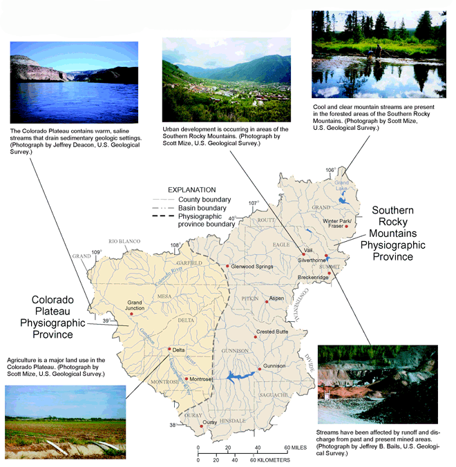
The Upper Colorado River Basin encompasses about 17,800 square miles. The primary river, the Colorado River, originates in the mountains of central Colorado and flows about 230 miles southwest into Utah. The basin is composed of two physiographic provinces: the Southern Rocky Mountains and the Colorado Plateau (fig. 1). The topography varies from rugged mountainous regions in the east to high plateaus bordered by steep cliffs along valleys in the west. Because of differences in altitude of about 10,000 feet from east to west, the climate ranges from alpine conditions to semiarid/arid conditions. Precipitation ranges from 40 inches or more per year at high elevations in the eastern part of the basin to less than 10 inches per year at low elevations in the western part of the basin (fig. 2).
|
|
| Figure 1. The combinations of physiography and land use produce different environments found in the UCOL. Physiographic provinces from Fenneman, 1946. |
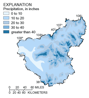 |
| Figure 2. Average annual precipitation (195180) in the UCOL (Colorado Climate Center, 1984). |
Snowmelt Runoff Dominates the Streamflow in Many Areas of the UCOL
The amount of water derived from the winter snowpack generally determines the magnitude and quality of streamflow for the UCOL. Streamflows are typically highest in the spring and lowest during the winter (fig. 3). The primary data-collection period for the UCOL study was water years 199698. Streamflow during water years 199697 was above average for most of the basin. Streamflow during water year 1998 was about average. High streamflows will dilute many water-quality constituents, resulting in lower concentrations. Suspended sediment and constituents associated with sediment may have larger concentrations during periods of high flow than during low flow.
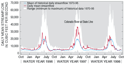 |
| Figure 3. Streamflows in the UCOL were above average in water years 1996 and 1997. Water year 1998 streamflow was near average. |
Irrigation is the Principal Water Use Within the UCOL
Irrigation accounts for 97 percent of the water use in the UCOL (fig. 4). Ninety-nine percent of the water used in the Study Unit is derived from surface-water sources (U.S. Geological Survey, 1995). Ground water accounts for 1 percent of water use and is an important resource in remote and rural areas where the water is used primarily for domestic purposes.
Water diverted eastward from the UCOL, through transmountain diversions, is used by many municipalities in the eastern plains of Colorado. This diverted water from the UCOL constitutes about 35 percent of the water supply for the city of Denver (Denver Water Department, 1999) and about 65 percent of the water supply for Colorado Springs (Scott Campbell, Colorado Springs Water Utility, oral commun., 2000). In addition, the Colorado Big Thompson project, using water diverted from the UCOL, provides complete or partial supply for more than 30 cities and towns in northern Colorado (Northern Colorado Water Conservancy District, 2000). Transmountain diversions can affect the water quality in the basin because the diversions can account for a substantial portion of the local streamflow in upstream areas. In addition, the diverted water commonly has low salinity that is no longer available to dilute more mineralized water in the downstream part of the Study Unit.
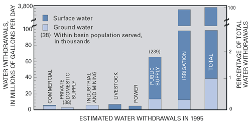 |
| Figure 4. Water use in the basin is primarily derived from surface water; however, ground water is used for some domestic and public water supplies. Transmountain diversions to eastern Colorado from the UCOL accounted for about 451 million gallons per day in 1995 (Upper Colorado River Commission, 1999). |
Water Quality is Influenced by Geologic Factors
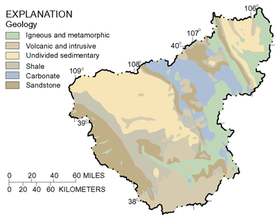 |
| Figure 5. The bedrock geology within the UCOL changes from predominately igneous, metamorphic, and volcanic rock types in the eastern and central areas to predominantly sedimentary rock types in the western areas (Tweto, 1979; Green, 1992). |
The underlying bedrock in the Study Unit is made up of crystalline and sedimentary rocks (fig. 5). Alluvium consisting of stream, landslide, terrace, and glacial deposits is present in valleys throughout the basin. Weathering of the different geologic units affects water-quality conditions in the basin. The sedimentary, igneous, and metamorphic rocks contribute material such as salts and trace elements to the streams. High concentrations of some materials, particularly salts, are derived from the sedimentary rocks, which are more common in the western part of the basin. Also, highly mineralized areas in the upper basin contribute trace metals to surface and ground water. Selenium occurs naturally in the shale bedrock of the middle and lower reaches of the basin and is present in surface and ground water. In addition, mineral hot springs located primarily in carbonate rock units in the north-central part of the basin contribute about 13 percent of the total salt load at the outlet of the UCOL (U.S. Department of the Interior, 1995; Butler, 1996).
Water Quality is Influenced by Land Use
The UCOL study was designed to investigate land-use influences on water quality (see Study Unit Design, page 21, for details). Urban development, mining, and agricultural were the three primary land uses investigated in the UCOL.
Urban development has the potential to affect the quality of surface and ground water by adding nutrients, bacteria, pesticides, hydrocarbons, trace elements, and salts from point and nonpoint sources and by changes to the natural landscape. Urban land use accounts for only 1 percent in the UCOL, which has a population of about 308,000 people (Bureau of the Census, 1999). By the year 2020, the population is projected to increase to more than 500,000 (Colorado Department of Local Affairs, 2000). Resident population increases do not reflect development and services for vacation properties. There are large seasonal fluctuations in nonresident populations within the basin due to recreational activities. During the 199697 ski season, more than 9 million skiers visited ski areas within the UCOL (Colorado Ski Country USA, 2000). Effects on water quality from urban development are evident in some communities in the Southern Rocky Mountains.
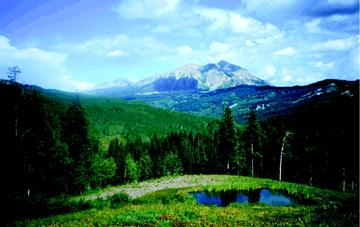 |
| Topography representative of the Southern Rocky Mountains. (Photograph by Jeffrey Deacon, U.S. Geological Survey.) |
Lode and placer mining, a historically significant land use in the UCOL, was common throughout the Southern Rocky Mountains. Streams and ground water have been affected by point-source mine discharge and nonpoint-source runoff from mined areas.
Areas of intensive agriculture are located primarily in the Colorado Plateau. Salinity, sediment, nutrients, pesticides, and selenium and other trace elements are common constituents in agricultural runoff. These constituents can have an adverse effect on the surface water, ground water, and aquatic life.
| Table of Contents || Previous Section || Next Section || Glossary U.S. Geological Survey Circular 1214 Suggested citation:
|
