
INTRODUCTION TO THE SACRAMENTO RIVER BASIN
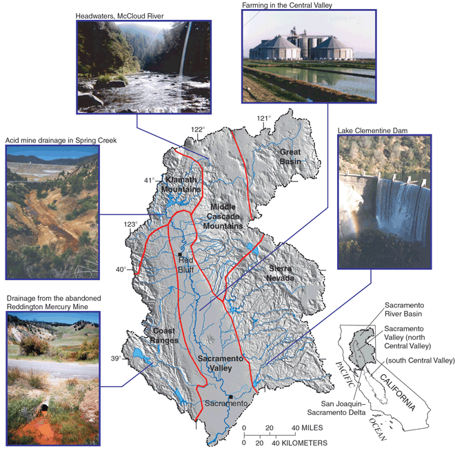
The Sacramento River Basin occupies nearly 70,000 square kilometers (km²) in the north central part of California (fig. 1). The Sacramento River is the largest river in California, with an average annual runoff of 27 billion cubic meters (m3) (Domagalski and Brown, 1998). The basin includes all or parts of six landforms or physiographic provincesthe Great Basin, the Middle Cascade Mountains, the Sierra Nevada, the Klamath Mountains, the Coast Ranges, and the Sacramento Valley (fig. 1). The Sacramento Valley is the low-lying province of the basin; the other provinces are mountainous. Land use in the mountainous regions of the basin is principally forest, although forest and rangeland are mixed in regions of the Coast Ranges and the Great Basin. Domagalski and others (1998) have provided more information on the physiographic provinces of the Sacramento River Basin.
The Sacramento Valley is the northern portion of the Central Valley of California and is fully contained in the Study Unit. The Sacramento Valley has the greatest population of any part of the basin, and it is there that the greatest effects or potential effects on surface and ground water are likely to occur from land-use activities. The Sacramento Valley is also the area of greatest water use in the basin.
 |
||
| Figure 1. Physiographic provinces in the Sacramento River Basin. Physiographic provinces are regions defined principally by geologic and topographic features. |
Land-Use Effects on Water Quality and Stream Habitat
The Sacramento Valley supports a diverse agricultural economy, much of which depends on the availability of irrigation water. Water is collected in reservoirs at several locations within the mountains surrounding the Sacramento Valley and is released according to allocations for agricultural, urban, and environmental needs. The reservoirs also are managed for flood control. The reservoirs provide flood protection and allow the storage of water during dry years, but the placement of dams at the reservoirs has blocked migration routes for salmonid fish.
More than 8,000 km² of the Sacramento Valley are irrigated. The major crops are rice, fruits, nuts, tomatoes, sugar beets, corn, alfalfa, and wheat. Dairy products also are an important agricultural commodity. The land areas adjacent to the Sacramento Valley are mostly forested (fig. 1).
The largest cities of the basin are in the Sacramento Valley and include Chico, Red Bluff, Redding, and Sacramento. The Sacramento metropolitan area is home to more than 1 million people, which is nearly half of the total population (U.S. Department of Commerce, 1992) in the basin.
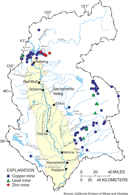
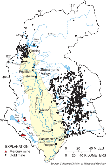
Previous mining for copper, lead, and zinc (fig. 2) in the Klamath Mountains has resulted in acid mine drainage (drainage of acidic waters from mines) into part of Keswick Reservoir, which is located immediately downstream from Shasta Lake. The drainage includes both mined metals and nonmined metals such as cadmium. Mercury that was used in previous mining within the Coast Ranges (fig. 3) enters the Sacramento Valley through Cache and Putah creeks. Although neither creek flows directly into the Sacramento River during low-flow conditions, the load of mercury can be transported to downstream receiving waters, including the San Francisco Bay, during stormwater runoff conditions. Mercury also can enter the Sacramento River from the Sierra Nevada, where it was used in historical gold mining (fig. 3).
 |
||
| Figure 2. Locations of copper, lead, and zinc mines. The most severe case of drainage of acidic waters from mines has been in the region near Shasta Lake. |
 |
||
| Figure 3. Locations of gold and mercury mines. The era of gold mining began in 1849 after the discovery of placer deposits in the American River. |
Water storage, transportation, and allocation in California are strategically managed to take into account the wide diversity of the States geography and physiography. Water is stored in nonpopulated areas of California and then transferred by natural stream channels or man-made canals to areas of demand. Reservoirs within the Sacramento River Basin have been constructed in the mountainous areas just adjacent to the valley. All major rivers of the Sacramento River Basin have one or more reservoirs, which were constructed during the late 1940s to late 1960s mainly for flood control. Storage capacity of the reservoirs is managed to capture runoff from winter storms. However, stored water is not used solely in the Sacramento River Basin; it is transported to other locations in California and is a major source of supply for Los Angeles and other southern California communities.
|
||
| Figure 4. Water allocations for average rainfall years for 1995 and projected for 2020. |
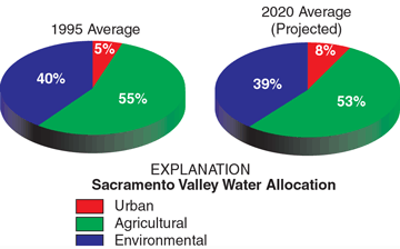
Total water use in the Sacramento River Basin is about 18 billion cubic meters per year (m3/yr). Allocations of water for agricultural, urban, and environmental uses are made according to the California water plan (California Department of Water Resources, 1998) but are modified on the basis of the yearly conditions of reservoir storage. For example, during drought years, total allocations are decreased. Pie charts in figure 4 show the percentage of allocations during average years of rainfall for 1995 and projected for 2020. Of those allocations, surface water provides 82 percent and ground water 18 percent of the total demand. During drought years, surface water drops to about 75 percent and ground water rises to about 25 percent of total demand.
Effects of Hydrologic Conditions on Study Results
The average annual precipitation for the entire Sacramento River Basin is 914 millimeters (mm), most of which falls as rain or snow during November through March. Because little or no rain falls during the summer growing season, irrigation is required for successful agriculture. Most of the water-quality samples for the Sacramento River Basin study were collected between the fall of 1995 and the spring of 1998, which covered a series of wet winters. Precipitation amounts in northern California are variable and dependent on the location of the Pacific jet stream. The average annual rainfall at the city of Sacramento is about 460 mm. Since the 1940s, however, as little as 140 mm and as much as 915 mm have been recorded in a year.
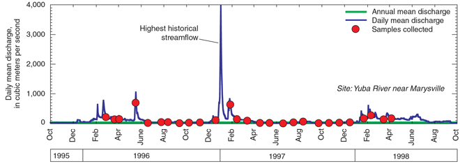
Two major hydrological events occurred during the period of this study. The first, a major flood, occurred during the winter of 199697. Flooding began on January 1, 1997, and affected a major part of the Sacramento River downstream from Shasta Lake as well as tributaries to the Sacramento River, especially the Feather and Yuba rivers. Some streams, such as the Yuba River, had the highest recorded streamflow following the rainfall associated with the flood of January 1, 1997 (fig. 5). The second major hydrological event was the El Niño episode of 199798. The term El Niño refers to an oceanatmosphere phenomenon during which wind and ocean current in the equatorial Pacific result in warmer-than-normal water along the North and South American Pacific coasts. El Niño winters frequently bring higher-than-normal precipitation in northern California because of a southward shift of the storm tracks and jet stream over North America.
 |
||
| Figure 5. Yuba River hydrograph. The highest recorded discharge for the lower Yuba River occurred shortly after a large rainfall on January 1, 1997. |
Study Design Focuses on Land Use
Chemical and biological samples were collected from rivers and streams within, or downstream from, forested, urban, agricultural, and mining areas to assess overall quality and effects of specific land-use practices. In most cases, river or stream sampling sites were located in the Sacramento Valleythe region of both the highest water use and where many potential effects on water quality had occurred and are likely to occur. At some sites, water samples were collected monthly and during storms to assess the effects of storm runoff on contaminant transport. Other sites were sampled only monthly, usually during normal flows. Shallow ground water was sampled from three areasthe highly used part of the southeastern Sacramento Valley aquifer, downstream from rice fields, and downstream from the recently urbanized area of metropolitan Sacramento. Domestic wells (existing wells) were sampled for the southeastern Sacramento Valley aquifer study area, whereas monitoring wells (drilled for this study) were sampled for the rice and urban land-use study areas.
| Table of Contents || Previous Section || Next Section || Glossary U.S. Geological Survey Circular 1215 Suggested citation:
|
