
MAJOR FINDINGS—Continued
Ambient Toxicity Monitoring by California State Agencies
Ambient toxicity testing uses laboratory bioassays to assess the effect of contaminants on aquatic life. Essentially, the tests answer the question: Can specific types of fish, invertebrates, and algae species continue to live, grow, and reproduce in water samples collected from water bodies? The EPA protocols (U.S. Environmental Protection Agency, 1991a,b) for conducting chronic toxicity tests on freshwater species include representatives from three phyla and trophic levels. The three species are the fathead minnow, a small planktonic crustacean (C. dubia), and a planktonic green alga (Selenastrum capricornutum). These three species have been used to evaluate ambient water quality in the Sacramento River Basin since 1986. California regulatory agencies rely on the tests for evaluating compliance with narrative toxicity objectives, which state that all waters shall be maintained free of toxic substances in concentrations that produce detrimental physiological responses in aquatic life (Marshack, 1995). Testing has changed from conducting broad watershed surveys that determine the spatial and temporal distribution of toxicity to conducting detailed follow-up studies that couple toxicity testing with a Toxicity Identification Evaluation (TIE) to identify specific chemicals and land uses responsible for toxicity. Water-quality data from the NAWQA Program are useful in determining the exposure of aquatic organisms to specific groups of contaminants such as organophosphate pesticides. Results from 13 years of monitoring suggest that the EPA toxicity tests are powerful tools for assessing water quality.
The toxicity testing program in the Sacramento River watershed was the first indicator of the potential water-quality problems currently associated with pesticide runoff from urban areas and orchards. Using C. dubia tests, pulses of toxicity have been detected over a 10-year period throughout the Sacramento Valley in waters that receive drainage from orchards (de Vlaming and others, 2000). The toxicity has been linked to diazinon applied to dormant orchards and chlorpyrifos applied to nondormant orchards. C. dubia also was effective in identifying toxicity attributed to drainage from rice fields. Rice-field drainage also was toxic to two important local species, larval striped bass and an invertebrate, N. mercedis. The invertebrate toxicity was caused by methyl parathion and carbofuran. As mentioned previously, a rice management program has eliminated the toxicity to all three species. C. dubia toxicity is detected throughout the year in waters that receive drainage from urban areas (fig. 10). This toxicity is attributed to diazinon and chlorpyrifos. Although most toxicity has been detected with C. dubia and linked to insecticides, other examples of ambient water toxicity have been identified. In areas of the Sacramento Valley that receive acid mine drainage, toxicity to S. capricornutum and C. dubia has been linked to copper and zinc. Mine remediation projects have reduced both metal concentrations and toxicity. Concentrations of copper and zinc measured in this NAWQA Program confirm that metal concentrations are below toxic levels (Alpers and others, 2000b). S. capricornutum toxicity has been documented in waters that receive agricultural or urban runoff. Some of the toxicity can be attributed to the herbicide diuron, also detected in samples collected by the NAWQA Program; however, additional unidentified toxicants are present. Fathead minnow toxicity has been traced to ammonia originating from dairies and wastewater treatment plants. Taken together, the results of the last decade reveal that all three testing procedures, in association with TIEs and chemical analyses, have been effective for the identification of an array of toxicants originating from various sources. In several cases, alternative land-use practices or management strategies have improved water quality, as demonstrated by toxicity test monitoring. Because resources are not available for monitoring the complete array of potential contaminants, toxicity testing is a useful tool for focusing on chemicals present in a water body at toxic levels.
| NAWQA Participation with Local Water-Quality Programs All NAWQA Study Units maintain communication and program coordination with a liaison committee of outside parties interested in water quality within the respective basins. During the early part of this NAWQA study, two significant programs were taking shape that involved new approaches to understanding and promoting the better management of water quality in the Sacramento River Basin. In 1994, Congress recognized the need to develop a coordinated, technically sound, adequately funded program that would focus on establishing toxic pollutant standards for the Sacramento River Basin. Congress then appropriated funds for the Sacramento River Toxic Pollutant Control Program (SRTPCP) and has continued to support the program. The long-term objective of the SRTPCP is to develop and implement a program that will bring the Sacramento River and its tributaries into compliance with water-quality standards for toxic pollutants and thereby protect beneficial uses. A second objective of the SRTPCP is to help form a viable organization of watershed stakeholders. The stakeholder organization is intended to address not only the related toxic-pollutant issues of the watershed, but also the broader water-quality and watershed issues that must be resolved to protect and enhance surface and ground water throughout the basin. The broader program to be conducted by this stakeholder organization has been named the Sacramento River Watershed Program (SRWP). The SRWP, although initiated with funding provided under the SRTPCP, is much broader in scope than the SRTPCP. The SRWP is intended to provide a forum to address a broad array of water-quality-related issues within the watershed, not just issues on toxic pollutants. Other issues that may be addressed under the broader watershed program include, but are not limited to, conventional water quality (including sediment, temperature, and dissolved solids), habitat, endangered species, streamflow, and ground-water issues. The NAWQA Program participates in various committees of the SRWP, including the monitoring committee, to share data. Data from the NAWQA Program are shared with the SRWP and are used to help interpret the current water-quality conditions and to help guide the continued management of the water resources of the Sacramento River Basin. |
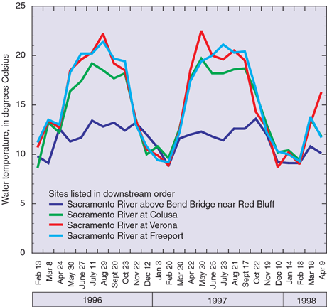 |
| Figure 17. Temperature of the Sacramento River at select locations. Seasonal increases are caused by diversion of river water for irrigation. |
Changes in land use in the Sacramento River Basin have had major effects on the streams in the basin and on the aquatic communities dependent on them. Riparian forests and wetlands have been removed or degraded. Water development activities, particularly construction of dams and reservoirs, have altered natural flow and water temperature. The seasonal nature of higher temperatures along a stretch of the Sacramento River downstream from Shasta Lake is shown in figure 17. Water diversions for irrigation result in less water in the Sacramento River and rapidly increasing temperatures that are potentially harmful to certain fish in the spring and summer, especially downstream from the site on the Sacramento River above Bend Bridge near Red Bluff. Collectively, these changes in streams have resulted in corresponding changes in native ecological communities, including species extirpation and population declines in remaining native species (Moyle and Nichols, 1974; Brown and Moyle, 1993; Brown, 2000). These declines have resulted in the listing of a number of animal and plant species as threatened or endangered under State or Federal law.
Native fish species are still common in Sacramento River Basin streams
Thirty-five species of fish were collected, including 12 species native to California. Statistical techniques were used to categorize sites on the basis of similar fish groupings. Four species of fish were collected at mountain streamsrainbow trout, brown trout, riffle sculpin, and chinook salmon. These species are generally associated with cold, clear water and are considered intolerant of other environmental conditions such as warm water. Only brown trout is an introduced species. Rainbow trout were collected at all sites and were the most abundant species, representing 74 percent of the fish collected.
Fish were also sampled at sites below the mountains but above the valley floor. Those sites are referred to as the foothill sites. Twenty-one species of fish, including 13 native species, were collected at the nine sites in the foothill group. None of the introduced species was abundant, and no introduced species represented more than 3 percent of the fish collected. Native minnows, hardhead, Sacramento pike-minnow, speckled dace, California roach, and Sacramento sucker dominated sites in this group.
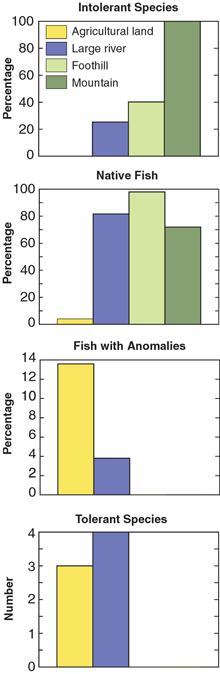 |
| Figure 18. Characteristics of fish from ecological studies. |
Twenty-four species of fish, including nine native species, were collected at the three large river sites, which are located at low elevations on the larger rivers. Native species tended to be more abundant. The most abundant native species were Sacramento pikeminnow, Sacramento sucker, tule perch, and prickly sculpin. No introduced species exceeded 7 percent of the catch.
Agricultural land sites within the Sacramento Valley were dominated by introduced species and included sites on natural and artificial waterways that were heavily influenced by agricultural land uses or water management activities. Twenty species were collected at these sites, including only three native species.
The group of fish at the agricultural land sites had the lowest percentage of native fish, the lowest percentage of intolerant fish, and the highest percentage of fish with external anomalies (fig. 18), indicating degraded environmental conditions. Intolerant fish are defined as those that are not adaptable to human alterations to the environment and thus decline in numbers when these alterations occur. The agricultural land site group also had a low number of native species compared with the large river and foothill site groups. In summary, the fish site data indicate that the agricultural land site group had the most degraded environmental conditions, the foothill and mountain site groups had the best conditions, and the large river site group had somewhat intermediate conditions.
Previous studies of fish community structure in California have established correlations between the increasing numbers of introduced fish species in Central Valley streams and the disturbances caused by human activities (Moyle and Nichols, 1974; Brown and Moyle, 1993; Brown, 2000). Environmental disturbances associated with human activities include changes in water quality, streamflow, and habitat. Changes in streamflow, in particular changes in quantity and timing, have been identified as very important determinants of the structure of California fish communities (Baltz and Moyle, 1993; Moyle and Light, 1996a,b; Brown, 2000).
Differences in water quantity and water management have subsequent effects on water quality and habitat. Although these observations do not provide definitive support for the primary importance of streamflow in maintaining populations of native fish species, such relations and their effects on native fishes warrant consideration whenever changes in water management are being considered. Assessments of resident fish communities may be useful in determining the effectiveness of such changes in restoring natural ecological functions.
Streams without large reservoirs supported higher abundance of aquatic insects than streams with large reservoirs
Aquatic insect communities were compared at 23 locations including sites on two streams, Big Chico and Deer creeks, which have no major dams. Most streams sampled as part of this NAWQA Program have at least one major water project that affects a portion of the natural channels. Big Chico and Deer creeks are, therefore, unique in this study in that their flows are largely unregulated. Statistical analyses of the aquatic insect communities show that some sites on Deer and Big Chico creeks have more species and greater abundances of benthic macroinvertebrates compared with sites downstream from dams on the other streams sampled. Further research is needed to verify and evaluate these relations.
Populations of anadromous salmonids, including steelhead, rainbow trout, and chinook salmon, have declined throughout the Central Valley, resulting in protection of the remaining populations under Federal and State endangered species legislation (Yoshiyama and others, 1998). The reasons for the declines are complex and interactive; however, the construction of dams and reservoirs on California streams and rivers is widely recognized as one of the important factors (Yoshiyama and others, 1998). Dams and reservoirs block established migration routes, causing fish to reproduce in less desirable habitats. Another ecological effect from dams and reservoirs can be changes in downstream populations of aquatic insects. This is potentially important to anadromous and resident fish populations because aquatic insects are a critical food source for nearly all species of fish at some life stage.
The implication of this study is that construction of dams and reservoirs in the foothills has either submerged the productive habitat in Central Valley streams or altered them indirectly through downstream effects on ecological conditions. The importance of other downstream effects, such as disruption of sediment transport, has been recognized for anadromous salmonids. As a result of this recognition, a variety of projects are underway or are being proposed to improve conditions for anadromous fishes and to restore ecological processes in general.
|
Biological indicators of water and habitat quality for 6 sites in the Sacramento River Basin were compared with similar data from 140 sites from NAWQA Study Units throughout the Nation. Because the rankings have not been calibrated for Sacramento River Basin streams, they should not be interpreted as designating good and bad water quality in streams. The sites simply score higher or lower in relation to other NAWQA sites, which represent a wide range of environmental settings. The Yuba River site ranked among the least degraded sites nationally for all three indicators. The consistently low scores for this site can be attributed to abundant native fishes and the presence of healthy invertebrate and algal communities associated with cool water and abundant riffle habitats. The Arcade Creek and Colusa Basin Drain sites ranked among the most degraded sites nationally for all three indicators. This score may have to do more with the harsh nature of the physical environment than with water quality. Flow at these sites fluctuates widely because of storm runoff and variation in urban runoff. Biological communities in such streams tend to have few species, resulting in low indicator scores. Local determination of habitat and water quality is better accomplished using locally derived data, as has been demonstrated for Central Valley fish (Brown, 2000; May and Brown, 2000) and invertebrate communities (Brown and May, 2000a,b).
|
|||||||||||||||||||||||||||||||||||||||||||||

Ground-water quality was investigated in the portion of the aquifer of the southeastern Sacramento Valley used for domestic purposes or irrigation and in the shallow portion of the aquifer below the valleys two major land usesrice cultivation and land that had been urbanized from 5 to 25 years ago. The southeastern Sacramento Valley was chosen for investigation because it is in that region that domestic and irrigation usage of ground water is highest. Although ground water is used in other parts of the valley, its usage is not as great as in the southeastern Sacramento Valley.
The ground-water quality of some areas of the Sacramento Valley, such as the southwestern portion, is not entirely suitable for human or agricultural use because of the presence of elevated concentrations of boron, fluoride, chloride, nitrate, and sulfate (Hull, 1984; Davisson and Criss, 1993). The study conducted in the south-eastern Sacramento Valley aquifer was designed to address the suitability of a portion of the aquifer. Specifically, only existing domestic wells were sampled.
Out of 31 wells sampled, only one sample exceeded the drinking water standard for nitrate. The median concentration of nitrate was 1.3 mg/L. Previous NAWQA investigations have found a median nitrate concentration of 0.48 mg/L in major aquifers throughout the United States (Nolan and Stoner, 2000). Therefore, the wells sampled in this study have nitrate values above the national median.
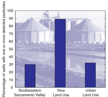 |
| Figure 19. Percentage of wells having one or more detected pesticides for the three ground-water studies. |
One or more pesticides were detected in 9 of 31, or 29 percent, of the wells of the southeastern Sacramento Valley (fig. 19). Simazine was detected in three wells, but the concentrations were very low and were not close to any drinking-water standard. Bentazon was one of the more frequently detected pesticides. Bentazon is a herbicide that was used on rice, but its use was suspended in 1989 pending a review; then, in 1992, it was formally banned by the California Department of Pesticide Regulation (Miller-Maes and others, 1993). All bentazon concentrations were below drinking-water standards.
Volatile organic chemicals (VOCs) are not causing any apparent water-quality problems in the shallow aquifer of the southeastern Sacramento Valley. In one of the wells sampled, which is down-gradient from a known point source, eight different VOCs were detected. One of those VOCs (trichloroethene, measured at 5.5 µg/L) exceeded current drinking-water standards (primary MCL is 5 µg/L).
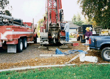
The effects of rice cultivationone of the most prevalent agricultural practices in the Sacramento Valleyon ground water were examined by drilling and sampling 28 new wells (fig. 20). The wells were drilled to completion near the water table so that the agricultural effects on the most recent water that entered the ground could be assessed. Rice cultivation requires that fields be flooded for the duration of the growing season, which lasts from May through September.
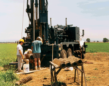 |
| Figure 20. Drilling and installing a new monitoring well in the rice-growing region of the Sacramento Valley. |
Pesticides were more frequently detected in the wells of the rice land-use study area compared with other regions outside the rice study area. One or more pesticides were detected in 25 of 28 (89 percent) of the wells sampled (fig. 19). The most frequently detected pesticide of the rice study was bentazon, a herbicide used in rice fields until suspension in 1989 and a formal ban in 1992. Although no observed concentrations exceeded drinking-water standards, the high detection frequency, almost 10 years since the last known use, suggests that bentazon is easily transported to ground water and does not readily degrade in ground water. Molinate, another herbicide used on rice, was detected in 7 out of 28 wells. Thiobencarb, also a herbicide, was found in three wells; carbofuran, an insecticide used on rice, was detected in four. Herbicides and insecticides are applied to rice at the same time, shortly after planting in May. The most heavily used pesticides on rice are molinate, thiobencarb, and carbofuran. Therefore, it is not surprising to see these compounds in the ground water under the rice land-use region. None of the pesticide concentrations that were measured exceeded any known water-quality standard.
Nutrient concentrations tended to be low in the ground water under the rice fields. The median nitrate concentration was 2 mg/L, and no concentrations exceeded a drinking-water standard. The median nitrate concentration measured in previous NAWQA investigations in agricultural land use settings was 3.4 mg/L (Nolan and Stoner, 2000).
Dissolved solids were elevated in rice fields relative to the other ground water sampled in this study. The elevated concentrations are most likely related to evaporation of irrigation water, which leaves behind salt. The effects of these increases in dissolved solids on deeper portions of the aquifer are unknown.
 |
| Figure 21. Drilling and installation of a new monitoring well in the Sacramento metropolitan area. This study of shallow ground water was the first of its kind within the Sacramento metropolitan area. |
The effects of recent urbanization on the quality of shallow ground water were investigated as part of this NAWQA study (fig. 21). The chosen metropolitan area was that of the city and surrounding counties of Sacramento. The part of the metropolitan area developed between 5 and 25 years ago was chosen for the investigation because it was assumed that the water quality of older urban land might have degraded water quality because it was developed prior to the passage of the Clean Water Act and the period of more recent environmental awareness.
Trichloromethane was the most frequently detected volatile organic chemical (16 of 19 wells). The concentrations were always very low and did not exceed any drinking-water standards. The presence of trichloromethane can be attributed to lawn irrigation using water treated by chlorination. One or more pesticides were detected in 6 of 19 (32 percent) of the wells sampled in the urban land-use study (fig. 19). Atrazine, or its degradation product, was the most frequently detected pesticide in the shallow ground water under the recently urbanized area. The occurrence of atrazine in ground water could not be attributed to either current urban land use or past agricultural production. All atrazine concentrations were below drinking-water standards.
An examination of the nitrate data revealed the highest potential contamination of ground water from recent urban development. Although no wells had concentrations of nitrate above the drinking-water standard, one well had a concentration of 8 mg/L, and 5 of the 19 (26 percent) of the sampled wells had concentrations that exceeded 5 mg/L. The median concentration of nitrate was 2.4 mg/L. The median concentration of nitrate in ground water under urban areas measured in previous NAWQA investigations was 1.6 mg/L (Nolan and Stoner, 2000).
With the exception of arsenic, trace elements generally were not found to be a problem from the perspective of human toxicity. Some wells did have high concentrations of iron and manganese. The primary drinking-water standard for cadmium (5 µg/L) was exceeded in three wells of the rice land-use study. The source of that cadmium is unknown. Arsenic exceeded the current drinking-water standard of 50 µg/L in one urban well and approached the drinking-water standard in three other wells. Arsenic would be more problematic if the drinking-water standard were lowered to 5 µg/L, as proposed by the EPA (U.S. Environmental Protection Agency, 2000). At that level, the standard would be exceeded in 53 percent of the urban wells, 39 percent of the rice land-use wells, and 48 percent of the domestic wells sampled in the southeastern Sacramento Valley. Iron and manganese dissolve when oxygen is absent in the ground water. Although generally nontoxic, these two metals can limit the beneficial uses of the ground water because they may precipitate when the ground water is exposed to air. The precipitation can be severe enough to adversely affect household uses of water as well as plumbing.
Radon concentrations exceeded the EPA proposed drinking-water standard of 300 picocuries per liter in 90 percent of the domestic wells sampled. The median concentration from wells sampled in the southeastern Sacramento Valley was 495 picocuries per liter. Radon is a colorless gas formed from the radioactive decay of radium. Radium is produced by the radioactive decay of uranium, which has a half-life of 4.4 billion years, whereas the half-life of solid radium is 1,620 years. Radon, on the other hand, has a half-life of only 3.8 days. Because radon is a gas, it moves easily in underground geologic environments and readily enters ground water. Regions of the country with geologic formations containing granite, volcanic rocks, certain types of shale known as dark shale, and some sedimentary and metamorphic rocks are more likely to have soil or ground water enriched in radon. Those conditions exist in the Sacramento River Basin. The health effects of consuming water containing radon at levels determined in this study have not been identified.
| Table of Contents || Previous Section || Next Section || Glossary U.S. Geological Survey Circular 1215 Suggested citation:
|
