| 
STUDY UNIT DESIGN
The Puget Sound Basin study was designed to address
local and national goals of providing widely comparable water-quality
data focused on stream chemistry, stream ecology, and ground-water chemistry.
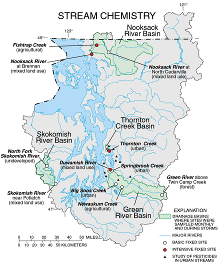
Of the 12 major and numerous minor tributaries to the
Puget Sound, sampling was concentrated in four representative drainage
basins: the Nooksack and Green River Basins with varied land uses, the
Thornton Creek Basin in a totally urban environment, and the Skokomish
River Basin, which is mostly forested.
Some sampling was done outside these areas for special
studies, such as the study of pesticides in urban streams. Wells sampled
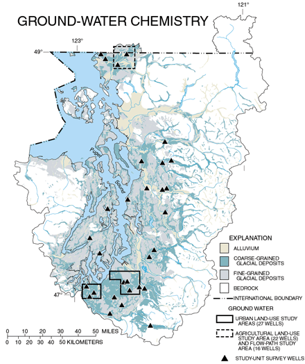
for the survey of ground-water quality in the Study Unit were distributed
throughout the Puget Lowlands.
Agricultural effects on ground-water quality and changes
in quality along flow paths were evaluated using wells located in the
lower Nooksack River Basin. Wells sampled in residential areas surrounding
Olympia and Tacoma were used for determining urban land-use effects on
shallow ground-water quality.
Stream ecology, bed sediment, and aquatic biota sampling
was done at all the fixed stream-chemistry sites, and one or more of these
types of samples were collected at 14 other sites. Two-thirds of the sites
were within the Puget Lowlands, while the remainder were in other ecoregions
(Black and Silkey, 1998).
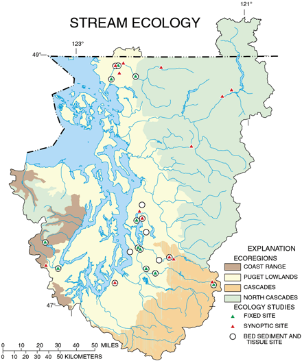 |
Table 3. Summary
of data collection in the Puget Sound Basin, 1994-981
|
Study component |
What data were collected and why |
Types of sites sampled |
Number of sites |
Sampling frequency and period |
|
Stream Chemistry |
| Basic
fixed sites-general water quality |
Streamflow,
dissolved oxygen, pH, alkalinity, specific
conductance, temperature, nutrients, major ions, trace elements,
organic carbon, and suspended sediment were measured to determine
occurrence and concentration. |
Streams
draining basins ranging in size from 12 to 790 square miles, reflecting
forest and mixed land use, and widely distributed geographically
within the Study Unit. |
7 |
Monthly plus storms
Mar. 1996-Apr. 1998 |
| Intensive
fixedsites-pesticides and VOCs |
Above
constituents plus 87 pesticides and 85 volatile organic compounds. |
Sites
selected for closer proximity to and more direct influence from
agricultural and urban land uses plus integration of mixed-use larger
basins. |
3
1 |
Weekly to monthly
Mar. 1996-May 1997
Weekly to monthly
Mar. 1996-May 1998 |
| Synoptic
sites-pesticides |
Streamflow,
pH, specific conductance, temperature plus
pesticides during varying flow conditions to relate occurrences
and concentrations to retail sales of pesticides. |
Sites
predominantly influenced by urban residential land use plus 1 reference
site. |
13 |
2 to 4 samples
over storm hydrograph
Apr.-May 1998 |
| Contaminants
in bed
sediment |
Trace
elements and organic compounds to determine
occurrence and distribution in
streambed sediment. |
Depositional
zones of all basic and intensive stream-chemistry sites plus additional
sites. |
19 |
Once
Sept. 1995 |
| Contaminants
in fish tissue |
Trace
elements and organic compounds in the tissue of whole fish. |
Same
sites from which bed sediment samples were collected. |
18 |
Once
Sept. 1995 |
|
Stream Ecology |
| Fixed
sites |
Invertebrate,
algae, and fish communities, streamflow, basic water chemistry,
and riparian habitat conditions surveyed to assess biological communities
in the basin. |
Sites
collected with basic and intensive stream-chemistry sites and having
contributing drainage areas from 12 to 790 square miles. |
11 |
Annually
1995-97
|
| Synoptic |
Invertebrate,
algae, and fish communities, streamflow,
nutrients, and habitat conditions surveyed to determine land-use
effects on biological communities. |
4 bed
sediment and tissue sites and 10 other sites influenced by various
land uses, with contributing drainage areas ranging from 3 to 48
square miles. |
14 |
Once
Sept.-Oct. 1996
|
|
Ground-Water Chemistry |
| Study
Unit-
varied land use |
Nutrients,
major ions, pesticides, volatile organic compounds, and radon in
shallow, unconfined glacial
outwash aquifer to assess the drinking-water quality of domestic
wells in the Fraser aquifer. |
Existing
domestic supply wells widely distributed through the Puget Lowlands. |
30 |
Once
1996 |
| Land
use-
residential |
Above
compounds to determine effects of urban land use on ground-water
quality in the Fraser aquifer. One-half of the wells were sampled
for radon. |
Monitoring
wells in urban residential areas with both sewer and private septic
systems. |
27
|
Once
1996-97 |
| Land
use-
agricultural |
Above
compounds, except radon, to determine effects of agricultural land
use on ground-water quality in the Fraser aquifer. |
Monitoring
wells (18) and existing domestic supply wells (4) in an area of
intensive row crops (raspberries, for example). |
22 |
Once
1997-98 |
| Flow
path-
agricultural |
Above
compounds, except radon, to determine changes in water quality occurring
as water moves from recharge to discharge areas. |
Shallow
and deep monitoring wells along flow paths in an agricultural watershed.
|
16 |
Varied
1997-98 |
|
Special Studies |
| Synoptic
study-micro-
biology and wastewater
chemicals |
Turbidity,
pH, specific conductance, temperature, waste-water chemicals, fecal-indicator
bacteria, coliphage, and coliphage
serotypes to determine occurrence and distribution in the Puget
Lowlands and infer sources of fecal contamination. |
Sites
predominantly influenced by urban and agricultural land use. |
31 |
Once
Aug. 1998 |
| Land
use and scale |
Invertebrates,
instream habitat, and riparian condition data from USGS and Washington
State Department of Ecology sites (common protocol) were combined
to evaluate land-use impacts at different spatial scales. |
Indicator
sites with smaller drainage basins and mixed land uses. |
20 USGS
25 WDOE |
Annually
Aug.-Sept. 1995-97 |
| Drinking-water
assessment-
pesticides |
Pesticides
collected in previous study used to estimate detection probability. |
Public-supply
wells throughout the Study Unit. |
78 |
Once
1994 |
| 1 Most
data were collected 1996-98. |
|
Table of Contents || Previous
Section || Next Section || Glossary
U.S. Geological Survey Circular
1216
Suggested citation:
Ebbert, J.C., Embrey, S.S., Black, R.W., Tesoriero, A.J., and Haggland A.L., 2000, Water Quality in the Puget Sound Basin, Washington and British Columbia, 1996–98: U.S. Geological Survey Circular 1216, 31 p., on-line at https://pubs.water.usgs.gov/circ1216/
|
|