E
Cooperative Science Helps Determine Water Availability in Southern California
Owens Valley, a long narrow valley along the eastern flank of the Sierra Nevada in east-central California, is the main source of water for the City of Los Angeles. Diversion of streamflow for irrigation in the early 1900’s and to the Owens River–Los Angeles Aqueduct after 1913 greatly altered the water budget of the valley. In 1970, a second pipeline to Los Angeles was completed, thereby increasing the capacity for exporting water. The additional water for Los Angeles was obtained by increasing surface-water diversions, by reducing irrigation, and by pumping ground water. As a result, ground-water levels were lowered, and native plants dependent on shallow ground water declined over large areas of the valley. The concern of residents that the additional export of water was degrading the environment of Owens Valley prompted lawsuits against Los Angeles. A clear, authoritative, and unbiased assessment of water availability in the valley was needed to settle the developing controversy.
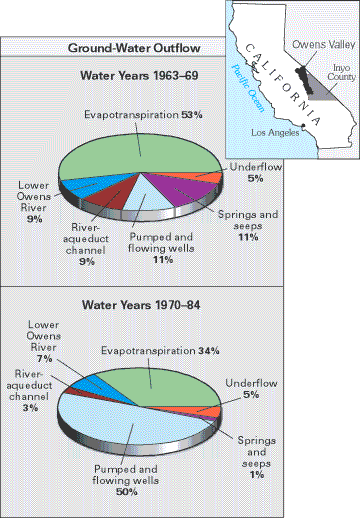
Consequently, the USGS was approached by Inyo County and the City of Los Angeles and in the early 1980’s began cooperative studies with them to evaluate the geology, water resources, and native vegetation of the valley. Hydrologic field investigations included innovative measurements of evapotranspiration, and simulations with a new valley-wide ground-water-flow model examined historical, current, and future water budgets for Owens Valley (Danskin, 1998). These USGS studies documented large decreases in evapotranspiration and springflows in response to water management in the 1970’s and 1980’s (fig. E–1) and projected even larger possible decreases in the future. As described in the settlement documents to pending lawsuits, the USGS studies “became the technical foundation for the joint long-term ground-water management plan” between Los Angeles and Inyo County, an operational plan designed to avoid long-term ground-water mining and the resultant adverse effects on native vegetation.
 |
|
Figure E–1. Simulated outflow components of the ground-water budget for Owens Valley for water years 1963–69 (prior to completion of the second Los Angeles aqueduct) and water years 1970–84 (during the initial operation of that aqueduct), showing large declines in evapotranspiration and springflow in response to large increases in ground-water pumpage (figure modified from Danskin, 1998). |
