Indicators of surface-water availability would include measures of both streamflow and surface-water storage, each of which change continuously in response to natural and human-induced processes (table 2).
Table 2. Mechanisms that cause changes in streamflow and surface-water storage
| Natural mechanisms | Human-induced mechanism |
|---|---|
|
Runoff from rainfall and snowmelt Evaporation from soil and surface-water bodies Transpiration by vegetation Ground-water discharge from aquifers Ground-water recharge from surface-water bodies Sedimentation of lakes and wetlands Formation or dissipation of glaciers, snowfields, and permafrost |
Surface-water withdrawals and transbasin diversions River-flow regulation for hydropower and navigation Construction, removal, and sedimentation of Stream channelization and levee construction Drainage or restoration of wetlands Land-use changes such as urbanization that alter rates of erosion, infiltration, overland flow, or evapotranspiration Wastewater outfalls Irrigation wastewater return flow |
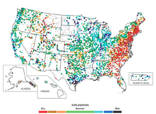
Currently, the USGS provides a number of assessment-type streamflow products at daily, weekly, and monthly time scales. These products, such as the online Water Watch Internet site of maps and graphs (fig. 3), are useful to emergency managers, public officials, and others tracking floods and droughts and to private citizens planning recreational activities. The USGS will continue to produce these types of information on daily to monthly conditions through our existing programs.
|
| Figure 3. Near-realtime streamflow map of the United States, December 5, 2001 (U.S. Geological Survey, 2001). Streamflow conditions across the country are reported daily by maps and graphs on the U.S. Geological Survey Water Watch Internet site (http://water.usgs.gov/waterwatch/). |
Streamflow indicators that support longer term water-availability decisions require more interpretive, value-added information at annual and longer time scales than is currently obtainable. To fulfill these longer term requirements, the following three specific types of streamflow indicators would need to be produced:
|
• |
Annual summaries (graphical and tabular) of surface-water discharge for each of the 352 hydrologic accounting units of the United States: Annual summaries would provide simple and concise representations of the net effects of climatic events, water management, and water withdrawals on surface-water supply during a year, as well as from one year to the next. |
|
• |
Periodic summaries of changes in surface-water discharge for each hydrologic accounting unit over periods of 5 to 10 years: Historically, some regions of the United States are pre- disposed to persistent periods of wetness or dryness. These periods can last a decade or more. To evaluate such persistent patterns and to gage their overall severity, periodic summaries of interannual change in surface-water supply are needed. |
|
• |
Periodic assessments of long-term trends in surface-water discharge in each hydrologic accounting unit: The ability to determine systematic long-term changes in surface-water supplies is an important capability of the national stream-gaging network. Recent questions associated with global climate and related environmental change increase the imperative for periodic assessments of trends in the Nation's water supply at regional and national scales. |
An example of the kind of information that can be discerned by analysis of long-term (multi- decadal) streamflow records across the Nation is given in figure 4, which depicts changes in the annual 7-day low flow for selected unregulated (fig. 4A) and regulated (fig. 4B) rivers. The annual 7-day low flow can be used as an indicator of hydrologic drought. The graphs in figure 4A indicate long-term low-flow changes on rivers that are minimally affected by surface-water diversions and reservoirs and are, therefore, more reflective of climatic variations. They provide a means of determining how annual dryness (including drought) has changed through time; for example, have droughts become more or less frequent or severe? In contrast, the graphs in figure 4B indicate changes on rivers where human activities have altered the natural flow, such as by dams and diversions. As such, they not only reflect the influence of climate but also provide information on how and where human activities have affected low streamflow and drought. In combination, the two sets of graphs give resource managers and policy makers important information on how and where low-flow conditions are changing around the Nation.
As part of the streamflow indicators, the assessment would provide an accounting of the status and trends in the availability of water for instream uses in various parts of the country by defining the amount of water remaining in a stream after offstream uses. Because instream-flow requirements can be estimated only by detailed analysis of local situations, an assessment would not estimate them.
 |
| Figure 4. The ability to determine systematic long-term changes in surface-water availability is an important capability of the national stream-gaging network maintained by the USGS. These graphs show annual 7-day low flow for the 70-year period from 1930 to 1999 on selected unregulated (A) and regulated (B) rivers. The annual 7-day low flow is a streamflow statistic that is often used as an indicator of hydrologic drought. Years when the annual 7-day low flow is relatively low typically correspond with drought or abnormally dry periods. The plots in figure 4A depict long-term changes in low flow on rivers that are not significantly affected by surface-water diversions and reservoirs, whereas those in figure 4B depict long-term changes in low flow on rivers where human activities have altered the natural flow, such as by dams and diversions. By assessing both situations, it is possible to determine how, where, and why hydrologic drought is changing in the United States. |
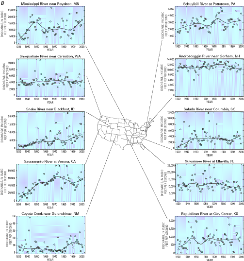 |
| Figure 4.—Continued. |
Indicators of the status and trends in surface-water storage would consist of annual summaries of storage conditions within each of the hydrologic accounting units; periodic summaries of changes in surface-water storage for each hydrologic accounting unit over periods of 5 to 10 years; and periodic assessments of long-term trends in surface-water storage in each hydrologic accounting unit. The indicators would account for storage changes in surface reservoirs and in selected natural freshwater bodies, including large lakes such as the Great Lakes and Lake Champlain, perennial snowfields, and glaciers.
The primary changes in surface-water storage in most basins arise from changes in the total capacity of, and conditions within, surface reservoirs. Reservoir construction in the United States and Puerto Rico peaked during the 1960’s and has slowed markedly since then (fig. 5). Presently, there are nearly 77,000 dams higher than 6 feet in the United States and Puerto Rico (U.S. Army Corps of Engineers, 2001). Because some reservoirs have multiple dams, this corresponds to about 68,000 reservoirs nationwide. Omitting dams that are control structures on large natural lakes, such as Superior or Okeechobee, the total volume of water stored in these reservoirs under typical conditions is about 422 million acre-feet (520 cubic kilometers) (Stallard, 1998).
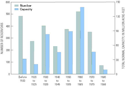 |
| Figure 5. Reservoirs are important indicators of water availability. The graph shows the number and total normal capacity of large reservoirs in the United States and Puerto Rico completed before 1920, during each decade from 1920 to 1979, and from 1980 to 1988. Normal capacity is the total volume in a reservoir below the normal retention level (figure from Ruddy and Hitt, 1990). |
Total reservoir storage conditions change in response to hydrologic and water-use variability, reservoir sedimentation, and reservoir construction and removal. An assessment would regularly update reservoir storage conditions and account for construction of new reservoirs, decreases in reservoir storage capacity due to sedimentation, and any removal of dams. The RESIS (Steffen, 1996) and RESIS-II (Stallard and others, 2001) databases of sediment deposition in U.S. reservoirs would serve as the basis for evaluating changes in reservoir sedimentation. These databases track losses in reservoir storage capacity throughout the United States and are the master databases for regional erosion studies (Stallard, 1998).
Development of indicators of surface- water storage would require close coordination with many agencies and groups because most reservoir data are collected and maintained primarily by agencies other than the USGS. A primary source of information on dams and reservoirs is the National Inventory of Dams, which is maintained by the U.S. Army Corps of Engineers in cooperation with the 50 States, Puerto Rico, the Association of State Dam Safety Officials, and 16 other Federal agencies. Additional data are available from city and State agencies and water districts that oversee or operate dams and reservoirs. Moreover, a large number of Federal and other governmental agencies presently monitor surface-water levels and reservoir storage on a continuing basis.
Back: Indicators of Water Availability
| AccessibilityFOIAPrivacyPolicies and Notices | |
 |
|