Long-term, systematic measurements of ground-water levels provide essential data needed to evaluate changes in ground-water storage over time. Using these data, the assessment would include two types of indicators to describe the nationwide status and trends of ground-water availability: ground-water-level indices and periodic assessments of changes in ground-water storage.
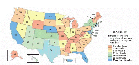
No nationwide, systematic ground-water-level monitoring program exists. At present there are approximately 42,000 long-term observation wells in the United States that have 5 or more years of water-level records (Taylor and Alley, 2002). The density of existing monitoring wells, however, varies considerably from State to State (fig. 6). The extent of water-level monitoring varies even more among major aquifers, with very limited monitoring in many aquifers. Thus, an inventory of existing water-level networks for major aquifer systems would be made early in the assessment to identify data gaps and opportunities for collaboration across the Nation.
|
| Figure 6. Number of ground-water-level observation wells having at least 5 years of water-level record per 1,000-square-mile area in each State and in Puerto Rico (modified from Taylor and Alley, 2002). |
The assessment should develop several indices of ground-water-level changes; some would represent composite indices for the Nation, whereas others would be analogous to “sector” indices in the stock market and would reflect specific geographic regions or specific types of aquifers, terrains, environments, or land-use settings. The various indices would provide water managers, major water users, and the public with quick summaries of the magnitudes and significance of trends in water-level changes.
To have national or even regional significance, indices of ground-water levels have to be based on repeated observations at relatively large numbers of observation wells located in a wide range of representative hydrogeological environments. Ground-water systems are dynamic and adjust continually to short-term and long-term changes in climate, ground- water withdrawals, and land uses. Water levels in wells change in response to a number of types of local and regional stresses, some of which are natural and some of which are human induced (table 3). Because sub- surface hydraulic properties are highly variable, water-level responses to stresses vary considerably with location and depth. Stresses take time to propagate through ground-water systems, so water-level changes are transient phenomena that are strongly affected by distances from the monitoring wells to imposed stresses.
Table 3. Mechanisms that cause changes in ground-water levels and storage (modified from Freeze and Cherry, 1979)
| Natural mechanisms | Human-induced mechanism |
|---|---|
|
Recharge Evaporation from the water table Transpiration by vegetation Discharge to streams, springs, and seeps Surface-water-level fluctuations in hydraulically connected streams, ponds, or lakes
|
Ground-water withdrawals Deep-well injection Agricultural irrigation Drainage of agricultural lands, swamps, and wetlands Artificial recharge of water Wastewater recharge through lagoons, landfills, and septic systems Dewatering of mines, tunnels, or other structures Leakage from surface-water reservoirs Urbanization impacts such as leaky water and sewer lines, lawn irrigation, and impervious surfaces (paved roads, parking lots, and so forth) |
Ground-water-level monitoring networks should include wells open to water-table aquifers and deep artesian aquifers, wells tapping a variety of rock types, wells located both near and distant from pumping centers, wells located in typical land-use settings, and wells that are widely distributed geographically. Because the magnitude of water-level fluctuations in wells depends on many factors, water levels in some wells may fluctuate by tens of feet within a day, but in other wells, water levels may change by only tenths of a foot over a year. Therefore, some wells may need to be monitored continuously, whereas others may only need to be measured once per year. Among the several indices that would be derived for this assessment, some might be updated daily, others might be updated monthly, and still others annually.
The amount of ground water in storage in the United States is changing (mostly decreasing) in response to ground-water withdrawals and other mechanisms shown in table 3. Data from several ground-water basins and aquifers already show significant depletions in freshwater availability over several decades. An example showing the greatest depletion (or ground-water mining) is the High Plains aquifer of the central United States, where ground-water withdrawals—primarily for irrigation—have caused large-scale, regional declines of the water table and accompanying reductions in ground-water storage (Box B).
Periodic national assessments of changes in aquifer storage due to ground-water withdrawals, saltwater intrusion, mine dewatering, land drainage, and other mechanisms that affect ground-water availability should be undertaken. These assessments would be based on nationwide summaries of observed water-level changes and ancillary data describing the aquifers and their changing storage conditions. These assessments would require a greater level of effort than that required for development of the ground-water-level indices because estimates of changes in ground-water storage require knowledge of aquifer storage properties and spatial interpolation of ground-water-level measurements. The assessment also could provide measures of the nationwide status of ground-water-supply infrastructure, such as changes in the number and capacity of water-supply wells and artificial recharge facilities; these measures would be analogous to those reported for surface-water reservoirs.
Changes in ground-water use and the effects of ground-water development are not usually as variable year to year as are those for surface water and, therefore, the periodic assessments of ground-water storage could be made at 5- to 10-year intervals. Ground-water-storage changes should be evaluated by major aquifer and then aggregated into regional and national assessments. A retrospective analysis of changes in ground-water storage during the 20th century would be made at the beginning of the assessment. In some cases, historical changes in ground-water storage may need to be estimated by use of ground-water simulation models that account for all ground-water storage processes, including storage changes in confining units. This modeling would build, in part, on work from the USGS Regional Aquifer-System Analysis (RASA) Program, which studied and modeled the Nation’s regional aquifers from 1978 to 1995.
Changes in ground-water storage over the past 100 years may be large enough to have global implications. If the volume of ground water stored on the continents has decreased significantly over the past century, then it might represent and account for a measurable fraction of the sea-level rise observed during that time period. This would have implications for global climate modeling and predictions of future sea-level rise. The impact of ground-water declines could be offset by increases in water stored in reservoirs, so global impacts must be assessed in light of both components of water storage. An assessment of changes in ground-water storage in the United States perhaps could be integrated into a global perspective in collaboration with other countries and international organizations.
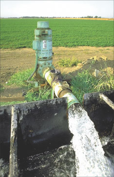 |
By pumping the vast reserves of ground water, farmers have developed the San Joaquin Valley of California into a major agricultural region. Photograph courtesy of the California Department of Water Resources. |
| AccessibilityFOIAPrivacyPolicies and Notices | |
 |
|