
By T. Jane Takahashi, Carl C. Abston, and Christina Heliker
Digital Data Series DDS-24
1995
U.S. Department of the Interior
Bruce Babbitt, Secretary
U.S. Geological Survey
Gordon P. Eaton, Director
Kilauea East Rift Zone eruption site
This Web page is a re-release of a CD-ROM publication that was produced in 1995. That CD-ROM used a DOS-based front-end and the images were in PCX format. For this re-release on the Web, the images were converted to JPG and saved at compression level 12 (the highest quality and largest file size). The original scans were only done at 256 colors and 1.5 megapixels which were a lot in those days. We tend to use 16.7 million colors and 6 megapixels these days and those parameters are still being increased. Many of these images plus newer ones are available at that higher quality at USGS DDS-80.
This report contains 475 scanned images from photographs held by the Hawaiian Volcanic Observatory, USGS. The images are intended to acquaint the user and educational community with examples of volocanic activity from the Kilauea East Rift Eruption Zone. High-quality prints/slides will be available at cost on request from the HVO Photographic Library.
The images were scanned from both color and black-and-white slides and photos. All images were scanned using a 256-color, 8-bit palette. The images were scanned using 200-1200-dot/inch resolution depending on the photo size. Each image is approximately 1.2 megabytes (1500 by 1000 pixels).
This publication includes the following:
1. Notes on the scope of this collection, including a "Selected References" list by T.J. Takahashi.
2. Narrative of the Kilauea East Rift eruption, 1983-1993, by C.C. Heliker.
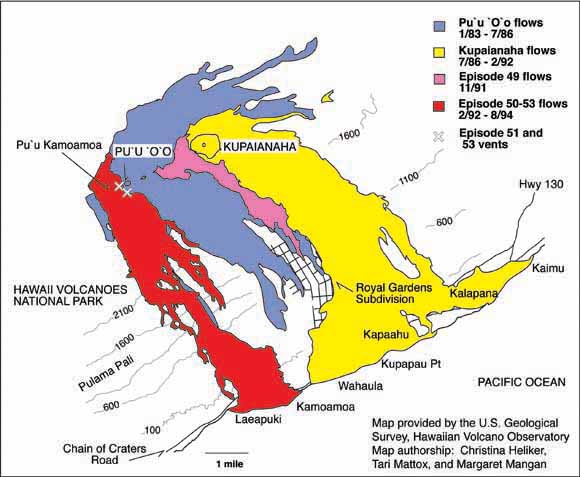
3. A map of locations referred to in the captions.
4. 420 images of the Kilauea East Rift eruption, scanned by C.C. Abston, with captions by T.J. Takahashi and C.C. Heliker.
5. A description of the work of HVO and its volcano monitoring activities by C.R. Thornber, P.G. Okubo, M. Lisowski, J.P. Kauahikaua, A.J. Sutton, and T. Elias.
6. A total of 55 images of the U.S. Geological Survey's Hawaiian Volcano Observatory's (HVO) volcano monitoring activities, including the work of the following groups:
a. Geology
b. Seismology
c. Ground Deformation
d. Geophysics
e. Geochemistry
View the text of this report (dds-24.txt; 96 KB)
View the captions for the images in this report (captions.txt; 112 KB)
To view PDF files on this Web site, you will need Adobe Acrobat Reader; you can download it at no cost using the button below.

View a 'contact sheet' of the photographs A “contact sheet” collection is provided here as PDF file. It consists of the 477 images with figure numbers. It contains 24 pages with 20 shots to the page. You can print it on standard letter paper or view it on your screen. The image numbers match the file names in the “photographs” folder below. (ContactSheet.pdf; 96 KB)
Go to the photographs folder (477 images that total 890 MB)