 Click here to view screen-resolution image - 45K
 Click here to view screen-resolution image - 45K
67. Landslide debris blocks both eastbound lanes of Highway 17 near Summit Road. [C.E. Meyer, U.S. Geological Survey]
 Click here to view screen-resolution image - 45K
68. Landslide debris blocks both eastbound lanes of Highway 17 near Summit Road. Foreground material is damaged lane separators. [C.E. Meyer, U.S. Geological Survey]
 Click here to view screen-resolution image - 45K
69. This roadcut near Summit Road failed during the initial earthquake and subsequent aftershocks. To mitigate further sliding, Caltrans decreased the slope angle. [J.K. Nakata, U.S. Geological Survey]
 Click here to view screen-resolution image - 45K
70. Damaged lane separators, Highway 17. [C.E. Meyer, U.S. Geological Survey]
 Click here to view screen-resolution image - 45K
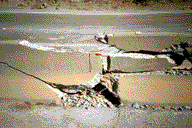
71. Broken concrete divider near the intersection of Summit Road and Highway 17. [R.A. Haugerud, U.S. Geological Survey]